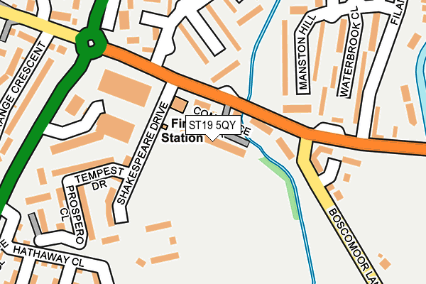
ST19 5QY is located in the Penkridge South & Gailey electoral ward, within the local authority district of South Staffordshire and the English Parliamentary constituency of Stafford. The Sub Integrated Care Board (ICB) Location is NHS Staffordshire and Stoke-on-Trent ICB - 05V and the police force is Staffordshire. This postcode has been in use since April 1985.


GetTheData
Source: OS OpenMap – Local (Ordnance Survey)
Source: OS VectorMap District (Ordnance Survey)
Licence: Open Government Licence (requires attribution)
| Easting | 392302 |
| Northing | 313254 |
| Latitude | 52.716901 |
| Longitude | -2.115393 |
GetTheData
Source: Open Postcode Geo
Licence: Open Government Licence
| Country | England |
| Postcode District | ST19 |
➜ See where ST19 is on a map ➜ Where is Penkridge? | |
GetTheData
Source: Land Registry Price Paid Data
Licence: Open Government Licence
Elevation or altitude of ST19 5QY as distance above sea level:
| Metres | Feet | |
|---|---|---|
| Elevation | 90m | 295ft |
Elevation is measured from the approximate centre of the postcode, to the nearest point on an OS contour line from OS Terrain 50, which has contour spacing of ten vertical metres.
➜ How high above sea level am I? Find the elevation of your current position using your device's GPS.
GetTheData
Source: Open Postcode Elevation
Licence: Open Government Licence
| Ward | Penkridge South & Gailey |
| Constituency | Stafford |
GetTheData
Source: ONS Postcode Database
Licence: Open Government Licence
| Fire Station (Boscomoor Lane) | Boscomoor | 64m |
| Fire Station (Boscomoor Lane) | Boscomoor | 78m |
| Boscomoor Close (Vale Gardens) | Boscomoor | 165m |
| Boscomoor Close (Val Gardens) | Boscomoor | 181m |
| Brook Close (Vale Gardens) | Rockhouse Estate | 241m |
| Penkridge Station | 0.8km |
GetTheData
Source: NaPTAN
Licence: Open Government Licence
GetTheData
Source: ONS Postcode Database
Licence: Open Government Licence


➜ Get more ratings from the Food Standards Agency
GetTheData
Source: Food Standards Agency
Licence: FSA terms & conditions
| Last Collection | |||
|---|---|---|---|
| Location | Mon-Fri | Sat | Distance |
| Boscomoor Road | 17:00 | 09:30 | 79m |
| Vale Gardens | 17:00 | 09:00 | 484m |
| Walhouse Drive | 17:00 | 09:15 | 572m |
GetTheData
Source: Dracos
Licence: Creative Commons Attribution-ShareAlike
The below table lists the International Territorial Level (ITL) codes (formerly Nomenclature of Territorial Units for Statistics (NUTS) codes) and Local Administrative Units (LAU) codes for ST19 5QY:
| ITL 1 Code | Name |
|---|---|
| TLG | West Midlands (England) |
| ITL 2 Code | Name |
| TLG2 | Shropshire and Staffordshire |
| ITL 3 Code | Name |
| TLG24 | Staffordshire CC |
| LAU 1 Code | Name |
| E07000196 | South Staffordshire |
GetTheData
Source: ONS Postcode Directory
Licence: Open Government Licence
The below table lists the Census Output Area (OA), Lower Layer Super Output Area (LSOA), and Middle Layer Super Output Area (MSOA) for ST19 5QY:
| Code | Name | |
|---|---|---|
| OA | E00151118 | |
| LSOA | E01029658 | South Staffordshire 001D |
| MSOA | E02006174 | South Staffordshire 001 |
GetTheData
Source: ONS Postcode Directory
Licence: Open Government Licence
| ST19 5LP | Boscomoor Close | 124m |
| ST19 5NU | Boscomoor Lane | 140m |
| ST19 5JZ | Manston Hill | 151m |
| ST19 5JX | Waterbrook Close | 195m |
| ST19 5NS | Wolverhampton Road | 197m |
| ST19 5LW | Brook Close | 216m |
| ST19 5LR | Vale Gardens | 234m |
| ST19 5JY | Rendermore Close | 267m |
| ST19 5LU | Grange Crescent | 288m |
| ST19 5LN | Otherton Close | 298m |
GetTheData
Source: Open Postcode Geo; Land Registry Price Paid Data
Licence: Open Government Licence