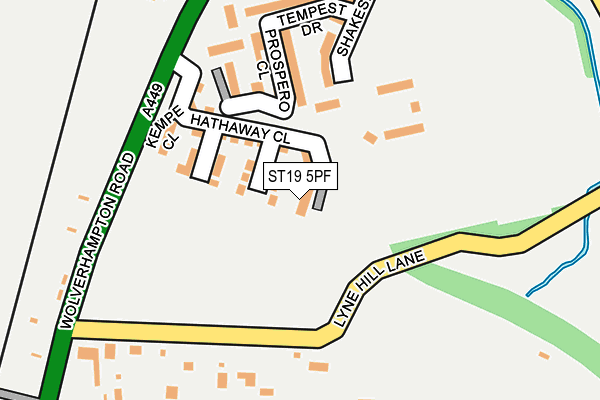
ST19 5PF is located in the Penkridge South & Gailey electoral ward, within the local authority district of South Staffordshire and the English Parliamentary constituency of Stafford. The Sub Integrated Care Board (ICB) Location is NHS Staffordshire and Stoke-on-Trent ICB - 05V and the police force is Staffordshire. This postcode has been in use since February 2017.


GetTheData
Source: OS OpenMap – Local (Ordnance Survey)
Source: OS VectorMap District (Ordnance Survey)
Licence: Open Government Licence (requires attribution)
| Easting | 392095 |
| Northing | 313037 |
| Latitude | 52.714947 |
| Longitude | -2.118452 |
GetTheData
Source: Open Postcode Geo
Licence: Open Government Licence
| Country | England |
| Postcode District | ST19 |
➜ See where ST19 is on a map ➜ Where is Penkridge? | |
GetTheData
Source: Land Registry Price Paid Data
Licence: Open Government Licence
| Ward | Penkridge South & Gailey |
| Constituency | Stafford |
GetTheData
Source: ONS Postcode Database
Licence: Open Government Licence
| Fire Station (Boscomoor Lane) | Boscomoor | 354m |
| Fire Station (Boscomoor Lane) | Boscomoor | 363m |
| Boscomoor Close (Vale Gardens) | Boscomoor | 381m |
| Boscomoor Close (Val Gardens) | Boscomoor | 412m |
| Bungham Lane (Wolverhampton Road) | Rockhouse Estate | 419m |
| Penkridge Station | 1km |
GetTheData
Source: NaPTAN
Licence: Open Government Licence
| Percentage of properties with Next Generation Access | 0.0% |
| Percentage of properties with Superfast Broadband | 0.0% |
| Percentage of properties with Ultrafast Broadband | 0.0% |
| Percentage of properties with Full Fibre Broadband | 0.0% |
Superfast Broadband is between 30Mbps and 300Mbps
Ultrafast Broadband is > 300Mbps
| Median download speed | 15.7Mbps |
| Average download speed | 14.8Mbps |
| Maximum download speed | 18.67Mbps |
| Median upload speed | 1.2Mbps |
| Average upload speed | 1.1Mbps |
| Maximum upload speed | 1.25Mbps |
| Percentage of properties unable to receive 2Mbps | 0.0% |
| Percentage of properties unable to receive 5Mbps | 0.0% |
| Percentage of properties unable to receive 10Mbps | 0.0% |
| Percentage of properties unable to receive 30Mbps | 100.0% |
GetTheData
Source: Ofcom
Licence: Ofcom Terms of Use (requires attribution)
GetTheData
Source: ONS Postcode Database
Licence: Open Government Licence


➜ Get more ratings from the Food Standards Agency
GetTheData
Source: Food Standards Agency
Licence: FSA terms & conditions
| Last Collection | |||
|---|---|---|---|
| Location | Mon-Fri | Sat | Distance |
| Boscomoor Road | 17:00 | 09:30 | 371m |
| Vale Gardens | 17:00 | 09:00 | 730m |
| Walhouse Drive | 17:00 | 09:15 | 784m |
GetTheData
Source: Dracos
Licence: Creative Commons Attribution-ShareAlike
The below table lists the International Territorial Level (ITL) codes (formerly Nomenclature of Territorial Units for Statistics (NUTS) codes) and Local Administrative Units (LAU) codes for ST19 5PF:
| ITL 1 Code | Name |
|---|---|
| TLG | West Midlands (England) |
| ITL 2 Code | Name |
| TLG2 | Shropshire and Staffordshire |
| ITL 3 Code | Name |
| TLG24 | Staffordshire CC |
| LAU 1 Code | Name |
| E07000196 | South Staffordshire |
GetTheData
Source: ONS Postcode Directory
Licence: Open Government Licence
The below table lists the Census Output Area (OA), Lower Layer Super Output Area (LSOA), and Middle Layer Super Output Area (MSOA) for ST19 5PF:
| Code | Name | |
|---|---|---|
| OA | E00151118 | |
| LSOA | E01029658 | South Staffordshire 001D |
| MSOA | E02006174 | South Staffordshire 001 |
GetTheData
Source: ONS Postcode Directory
Licence: Open Government Licence
| ST19 5NT | Lyne Hill Lane | 185m |
| ST19 5NS | Wolverhampton Road | 220m |
| ST19 5LU | Grange Crescent | 269m |
| ST19 5NU | Boscomoor Lane | 366m |
| ST19 5NH | Bungham Lane | 372m |
| ST19 5LP | Boscomoor Close | 383m |
| ST19 5JZ | Manston Hill | 450m |
| ST19 5NW | Grange Avenue | 457m |
| ST19 5LR | Vale Gardens | 469m |
| ST19 5JX | Waterbrook Close | 492m |
GetTheData
Source: Open Postcode Geo; Land Registry Price Paid Data
Licence: Open Government Licence