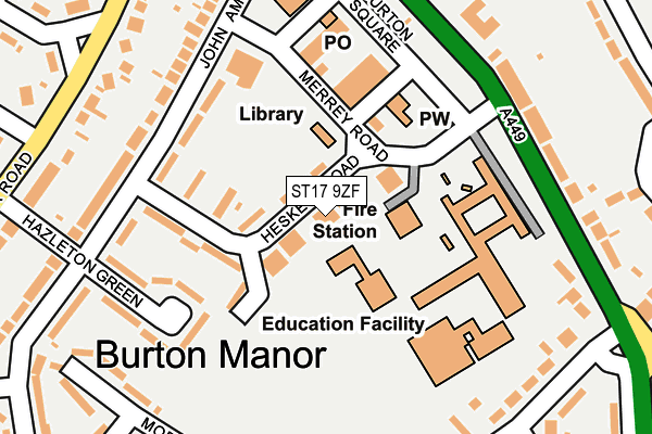
ST17 9ZF is located in the Manor electoral ward, within the local authority district of Stafford and the English Parliamentary constituency of Stafford. The Sub Integrated Care Board (ICB) Location is NHS Staffordshire and Stoke-on-Trent ICB - 05V and the police force is Staffordshire. This postcode has been in use since February 2017.


GetTheData
Source: OS OpenMap – Local (Ordnance Survey)
Source: OS VectorMap District (Ordnance Survey)
Licence: Open Government Licence (requires attribution)
| Easting | 392074 |
| Northing | 320947 |
| Latitude | 52.786054 |
| Longitude | -2.118957 |
GetTheData
Source: Open Postcode Geo
Licence: Open Government Licence
| Country | England |
| Postcode District | ST17 |
➜ See where ST17 is on a map ➜ Where is Stafford? | |
GetTheData
Source: Land Registry Price Paid Data
Licence: Open Government Licence
| Ward | Manor |
| Constituency | Stafford |
GetTheData
Source: ONS Postcode Database
Licence: Open Government Licence
| Hesketh Road (John Amery Drive) | Burton Manor | 172m |
| Hesketh Road (John Amery Drive) | Burton Manor | 192m |
| High School (Rising Brook) | Rising Brook | 197m |
| Royal Oak Ph (Wolverhampton Rd) | Rising Brook | 200m |
| Royal Oak Ph (Wolverhampton Road) | Rising Brook | 234m |
| Stafford Station | 2km |
GetTheData
Source: NaPTAN
Licence: Open Government Licence
| Percentage of properties with Next Generation Access | 100.0% |
| Percentage of properties with Superfast Broadband | 100.0% |
| Percentage of properties with Ultrafast Broadband | 0.0% |
| Percentage of properties with Full Fibre Broadband | 0.0% |
Superfast Broadband is between 30Mbps and 300Mbps
Ultrafast Broadband is > 300Mbps
| Median download speed | 39.1Mbps |
| Average download speed | 29.3Mbps |
| Maximum download speed | 59.99Mbps |
| Median upload speed | 9.8Mbps |
| Average upload speed | 7.7Mbps |
| Maximum upload speed | 20.00Mbps |
| Percentage of properties unable to receive 2Mbps | 0.0% |
| Percentage of properties unable to receive 5Mbps | 0.0% |
| Percentage of properties unable to receive 10Mbps | 0.0% |
| Percentage of properties unable to receive 30Mbps | 0.0% |
GetTheData
Source: Ofcom
Licence: Ofcom Terms of Use (requires attribution)
GetTheData
Source: ONS Postcode Database
Licence: Open Government Licence


➜ Get more ratings from the Food Standards Agency
GetTheData
Source: Food Standards Agency
Licence: FSA terms & conditions
| Last Collection | |||
|---|---|---|---|
| Location | Mon-Fri | Sat | Distance |
| Uplands Road | 17:15 | 10:45 | 329m |
| Silkmore Post Office | 17:15 | 10:30 | 722m |
| St Johns Road | 17:20 | 09:30 | 729m |
GetTheData
Source: Dracos
Licence: Creative Commons Attribution-ShareAlike
The below table lists the International Territorial Level (ITL) codes (formerly Nomenclature of Territorial Units for Statistics (NUTS) codes) and Local Administrative Units (LAU) codes for ST17 9ZF:
| ITL 1 Code | Name |
|---|---|
| TLG | West Midlands (England) |
| ITL 2 Code | Name |
| TLG2 | Shropshire and Staffordshire |
| ITL 3 Code | Name |
| TLG24 | Staffordshire CC |
| LAU 1 Code | Name |
| E07000197 | Stafford |
GetTheData
Source: ONS Postcode Directory
Licence: Open Government Licence
The below table lists the Census Output Area (OA), Lower Layer Super Output Area (LSOA), and Middle Layer Super Output Area (MSOA) for ST17 9ZF:
| Code | Name | |
|---|---|---|
| OA | E00151468 | |
| LSOA | E01029727 | Stafford 013D |
| MSOA | E02006200 | Stafford 013 |
GetTheData
Source: ONS Postcode Directory
Licence: Open Government Licence
| ST17 9NG | Hesketh Road | 43m |
| ST17 9NF | Hesketh Road | 76m |
| ST17 9ND | Hesketh Road | 115m |
| ST17 9LU | Burton Court | 131m |
| ST17 9NB | John Amery Drive | 149m |
| ST17 9LT | Burton Square | 165m |
| ST17 9NA | John Amery Drive | 196m |
| ST17 9NH | Hazleton Green | 200m |
| ST17 9DH | Rising Brook | 211m |
| ST17 9LZ | John Amery Drive | 212m |
GetTheData
Source: Open Postcode Geo; Land Registry Price Paid Data
Licence: Open Government Licence