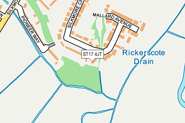
ST17 4JT is located in the Weeping Cross & Wildwood electoral ward, within the local authority district of Stafford and the English Parliamentary constituency of Stafford. The Sub Integrated Care Board (ICB) Location is NHS Staffordshire and Stoke-on-Trent ICB - 05V and the police force is Staffordshire. This postcode has been in use since July 2017.


GetTheData
Source: OS OpenMap – Local (Ordnance Survey)
Source: OS VectorMap District (Ordnance Survey)
Licence: Open Government Licence (requires attribution)
| Easting | 393335 |
| Northing | 321188 |
| Latitude | 52.788238 |
| Longitude | -2.100265 |
GetTheData
Source: Open Postcode Geo
Licence: Open Government Licence
| Country | England |
| Postcode District | ST17 |
➜ See where ST17 is on a map ➜ Where is Stafford? | |
GetTheData
Source: Land Registry Price Paid Data
Licence: Open Government Licence
| Ward | Weeping Cross & Wildwood |
| Constituency | Stafford |
GetTheData
Source: ONS Postcode Database
Licence: Open Government Licence
2022 5 APR £400,000 |
2, MANDARIN WALK, STAFFORD, ST17 4JT 2017 19 MAY £308,000 |
GetTheData
Source: HM Land Registry Price Paid Data
Licence: Contains HM Land Registry data © Crown copyright and database right 2025. This data is licensed under the Open Government Licence v3.0.
| Co-op Store (Silkmore Lane) | Rising Brook | 340m |
| Co-op Store (Silkmore Lane) | Rising Brook | 349m |
| Silkmore Crescent (Silkmore Lane) | Queensville | 353m |
| Silkmore Crescent (Silkmore Ln) | Queensville | 357m |
| Peach Avenue (Exeter Street) | Rising Brook | 416m |
| Stafford Station | 2.3km |
GetTheData
Source: NaPTAN
Licence: Open Government Licence
| Percentage of properties with Next Generation Access | 100.0% |
| Percentage of properties with Superfast Broadband | 100.0% |
| Percentage of properties with Ultrafast Broadband | 0.0% |
| Percentage of properties with Full Fibre Broadband | 0.0% |
Superfast Broadband is between 30Mbps and 300Mbps
Ultrafast Broadband is > 300Mbps
| Percentage of properties unable to receive 2Mbps | 0.0% |
| Percentage of properties unable to receive 5Mbps | 0.0% |
| Percentage of properties unable to receive 10Mbps | 0.0% |
| Percentage of properties unable to receive 30Mbps | 0.0% |
GetTheData
Source: Ofcom
Licence: Ofcom Terms of Use (requires attribution)
GetTheData
Source: ONS Postcode Database
Licence: Open Government Licence


➜ Get more ratings from the Food Standards Agency
GetTheData
Source: Food Standards Agency
Licence: FSA terms & conditions
| Last Collection | |||
|---|---|---|---|
| Location | Mon-Fri | Sat | Distance |
| Silkmore Crescent | 17:15 | 10:15 | 354m |
| Exeter Street | 17:15 | 10:15 | 621m |
| Silkmore Post Office | 17:15 | 10:30 | 649m |
GetTheData
Source: Dracos
Licence: Creative Commons Attribution-ShareAlike
The below table lists the International Territorial Level (ITL) codes (formerly Nomenclature of Territorial Units for Statistics (NUTS) codes) and Local Administrative Units (LAU) codes for ST17 4JT:
| ITL 1 Code | Name |
|---|---|
| TLG | West Midlands (England) |
| ITL 2 Code | Name |
| TLG2 | Shropshire and Staffordshire |
| ITL 3 Code | Name |
| TLG24 | Staffordshire CC |
| LAU 1 Code | Name |
| E07000197 | Stafford |
GetTheData
Source: ONS Postcode Directory
Licence: Open Government Licence
The below table lists the Census Output Area (OA), Lower Layer Super Output Area (LSOA), and Middle Layer Super Output Area (MSOA) for ST17 4JT:
| Code | Name | |
|---|---|---|
| OA | E00151511 | |
| LSOA | E01029735 | Stafford 016D |
| MSOA | E02006203 | Stafford 016 |
GetTheData
Source: ONS Postcode Directory
Licence: Open Government Licence
| ST17 4JR | Pintail Close | 100m |
| ST17 4JL | Silkmore Crescent | 161m |
| ST17 4JS | Mallard Avenue | 182m |
| ST17 4JF | Pioneer Way | 205m |
| ST17 4JH | Silkmore Lane | 327m |
| ST17 4PE | York Road | 372m |
| ST17 4NT | Meadow Way | 381m |
| ST17 4PB | Windsor Road | 395m |
| ST17 4XS | Catalan Close | 416m |
| ST17 4XR | Tarragona Drive | 437m |
GetTheData
Source: Open Postcode Geo; Land Registry Price Paid Data
Licence: Open Government Licence