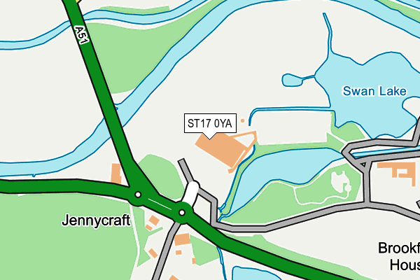
ST17 0YA is located in the Haywood & Hixon electoral ward, within the local authority district of Stafford and the English Parliamentary constituency of Stafford. The Sub Integrated Care Board (ICB) Location is NHS Staffordshire and Stoke-on-Trent ICB - 05V and the police force is Staffordshire. This postcode has been in use since January 1991.


GetTheData
Source: OS OpenMap – Local (Ordnance Survey)
Source: OS VectorMap District (Ordnance Survey)
Licence: Open Government Licence (requires attribution)
| Easting | 402191 |
| Northing | 320353 |
| Latitude | 52.780755 |
| Longitude | -1.968958 |
GetTheData
Source: Open Postcode Geo
Licence: Open Government Licence
| Country | England |
| Postcode District | ST17 |
➜ See where ST17 is on a map | |
GetTheData
Source: Land Registry Price Paid Data
Licence: Open Government Licence
Elevation or altitude of ST17 0YA as distance above sea level:
| Metres | Feet | |
|---|---|---|
| Elevation | 70m | 230ft |
Elevation is measured from the approximate centre of the postcode, to the nearest point on an OS contour line from OS Terrain 50, which has contour spacing of ten vertical metres.
➜ How high above sea level am I? Find the elevation of your current position using your device's GPS.
GetTheData
Source: Open Postcode Elevation
Licence: Open Government Licence
| Ward | Haywood & Hixon |
| Constituency | Stafford |
GetTheData
Source: ONS Postcode Database
Licence: Open Government Licence
| Garden Centre (Wolseley Rd) | Wolseley Bridge | 104m |
| The Old Barns (A51) | Wolseley Bridge | 129m |
| Bishton Lane (A51) | Bishton | 299m |
| Bishton Lane (A51) | Bishton | 335m |
| Shell Garage (A51) | Bishton | 592m |
| Rugeley Trent Valley Station | 2.9km |
| Rugeley Town Station | 3.6km |
GetTheData
Source: NaPTAN
Licence: Open Government Licence
GetTheData
Source: ONS Postcode Database
Licence: Open Government Licence


➜ Get more ratings from the Food Standards Agency
GetTheData
Source: Food Standards Agency
Licence: FSA terms & conditions
| Last Collection | |||
|---|---|---|---|
| Location | Mon-Fri | Sat | Distance |
| Wolseley Bridge Post Office | 16:45 | 11:30 | 588m |
| Wolsley Close | 17:00 | 08:30 | 1,108m |
| Little Haywood Post Office | 17:00 | 08:15 | 1,943m |
GetTheData
Source: Dracos
Licence: Creative Commons Attribution-ShareAlike
| Risk of ST17 0YA flooding from rivers and sea | Medium |
| ➜ ST17 0YA flood map | |
GetTheData
Source: Open Flood Risk by Postcode
Licence: Open Government Licence
The below table lists the International Territorial Level (ITL) codes (formerly Nomenclature of Territorial Units for Statistics (NUTS) codes) and Local Administrative Units (LAU) codes for ST17 0YA:
| ITL 1 Code | Name |
|---|---|
| TLG | West Midlands (England) |
| ITL 2 Code | Name |
| TLG2 | Shropshire and Staffordshire |
| ITL 3 Code | Name |
| TLG24 | Staffordshire CC |
| LAU 1 Code | Name |
| E07000197 | Stafford |
GetTheData
Source: ONS Postcode Directory
Licence: Open Government Licence
The below table lists the Census Output Area (OA), Lower Layer Super Output Area (LSOA), and Middle Layer Super Output Area (MSOA) for ST17 0YA:
| Code | Name | |
|---|---|---|
| OA | E00151388 | |
| LSOA | E01029711 | Stafford 008C |
| MSOA | E02006195 | Stafford 008 |
GetTheData
Source: ONS Postcode Directory
Licence: Open Government Licence
| ST17 0XS | 144m | |
| ST17 0XP | 329m | |
| ST17 0XR | Orchard Lane | 417m |
| ST17 0XL | 553m | |
| ST17 0XJ | 558m | |
| ST17 0XW | Bishton Lane | 561m |
| ST18 0XE | Bishton Lane | 587m |
| ST17 0XQ | Main Road | 933m |
| ST17 0XH | Main Road | 935m |
| ST17 0XG | Wolseley Close | 1088m |
GetTheData
Source: Open Postcode Geo; Land Registry Price Paid Data
Licence: Open Government Licence