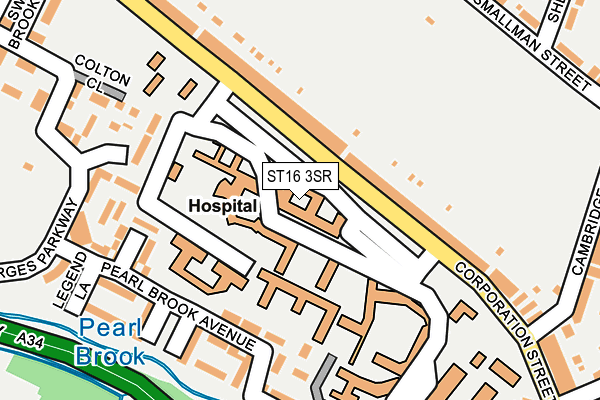
ST16 3SR is located in the Coton electoral ward, within the local authority district of Stafford and the English Parliamentary constituency of Stafford. The Sub Integrated Care Board (ICB) Location is NHS Staffordshire and Stoke-on-Trent ICB - 05V and the police force is Staffordshire. This postcode has been in use since July 1986.


GetTheData
Source: OS OpenMap – Local (Ordnance Survey)
Source: OS VectorMap District (Ordnance Survey)
Licence: Open Government Licence (requires attribution)
| Easting | 392732 |
| Northing | 323682 |
| Latitude | 52.810650 |
| Longitude | -2.109263 |
GetTheData
Source: Open Postcode Geo
Licence: Open Government Licence
| Country | England |
| Postcode District | ST16 |
➜ See where ST16 is on a map ➜ Where is Stafford? | |
GetTheData
Source: Land Registry Price Paid Data
Licence: Open Government Licence
Elevation or altitude of ST16 3SR as distance above sea level:
| Metres | Feet | |
|---|---|---|
| Elevation | 80m | 262ft |
Elevation is measured from the approximate centre of the postcode, to the nearest point on an OS contour line from OS Terrain 50, which has contour spacing of ten vertical metres.
➜ How high above sea level am I? Find the elevation of your current position using your device's GPS.
GetTheData
Source: Open Postcode Elevation
Licence: Open Government Licence
| Ward | Coton |
| Constituency | Stafford |
GetTheData
Source: ONS Postcode Database
Licence: Open Government Licence
| Sheridan Street (Smallman St) | Coton Fields | 267m |
| Sheridan Street (Smallman Street) | Coton Fields | 302m |
| Tithe Barn Road (Corporation St) | Littleworth | 332m |
| Smallman Street (Blakiston Street) | Coton Fields | 345m |
| Corporation Street (Tithe Barn Road) | Littleworth | 356m |
| Stafford Station | 1.1km |
GetTheData
Source: NaPTAN
Licence: Open Government Licence
GetTheData
Source: ONS Postcode Database
Licence: Open Government Licence


➜ Get more ratings from the Food Standards Agency
GetTheData
Source: Food Standards Agency
Licence: FSA terms & conditions
| Last Collection | |||
|---|---|---|---|
| Location | Mon-Fri | Sat | Distance |
| Crooked Bridge Road | 17:15 | 09:30 | 416m |
| Prospect Road | 17:15 | 09:30 | 511m |
| Eastgate Street | 17:30 | 11:45 | 529m |
GetTheData
Source: Dracos
Licence: Creative Commons Attribution-ShareAlike
The below table lists the International Territorial Level (ITL) codes (formerly Nomenclature of Territorial Units for Statistics (NUTS) codes) and Local Administrative Units (LAU) codes for ST16 3SR:
| ITL 1 Code | Name |
|---|---|
| TLG | West Midlands (England) |
| ITL 2 Code | Name |
| TLG2 | Shropshire and Staffordshire |
| ITL 3 Code | Name |
| TLG24 | Staffordshire CC |
| LAU 1 Code | Name |
| E07000197 | Stafford |
GetTheData
Source: ONS Postcode Directory
Licence: Open Government Licence
The below table lists the Census Output Area (OA), Lower Layer Super Output Area (LSOA), and Middle Layer Super Output Area (MSOA) for ST16 3SR:
| Code | Name | |
|---|---|---|
| OA | E00168499 | |
| LSOA | E01029725 | Stafford 009D |
| MSOA | E02006196 | Stafford 009 |
GetTheData
Source: ONS Postcode Directory
Licence: Open Government Licence
| ST16 3LS | Corporation Street | 150m |
| ST16 3WG | Shielding Way | 168m |
| ST16 3LT | Corporation Street | 182m |
| ST16 3WN | White Steed Close | 188m |
| ST16 3WJ | Pearl Brook Avenue | 194m |
| ST16 3WF | St Georges Parkway | 206m |
| ST16 3YD | Colton Close | 220m |
| ST16 3WL | Legend Lane | 237m |
| ST16 3WY | Newbolt Walk | 252m |
| ST16 3PF | Smallman Street | 293m |
GetTheData
Source: Open Postcode Geo; Land Registry Price Paid Data
Licence: Open Government Licence