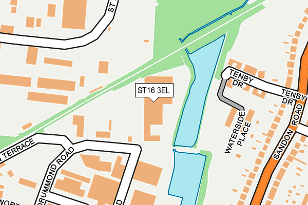
ST16 3EL is located in the Common electoral ward, within the local authority district of Stafford and the English Parliamentary constituency of Stafford. The Sub Integrated Care Board (ICB) Location is NHS Staffordshire and Stoke-on-Trent ICB - 05V and the police force is Staffordshire. This postcode has been in use since January 1980.


GetTheData
Source: OS OpenMap – Local (Ordnance Survey)
Source: OS VectorMap District (Ordnance Survey)
Licence: Open Government Licence (requires attribution)
| Easting | 392500 |
| Northing | 324971 |
| Latitude | 52.822234 |
| Longitude | -2.112735 |
GetTheData
Source: Open Postcode Geo
Licence: Open Government Licence
| Country | England |
| Postcode District | ST16 |
➜ See where ST16 is on a map ➜ Where is Stafford? | |
GetTheData
Source: Land Registry Price Paid Data
Licence: Open Government Licence
Elevation or altitude of ST16 3EL as distance above sea level:
| Metres | Feet | |
|---|---|---|
| Elevation | 80m | 262ft |
Elevation is measured from the approximate centre of the postcode, to the nearest point on an OS contour line from OS Terrain 50, which has contour spacing of ten vertical metres.
➜ How high above sea level am I? Find the elevation of your current position using your device's GPS.
GetTheData
Source: Open Postcode Elevation
Licence: Open Government Licence
| Ward | Common |
| Constituency | Stafford |
GetTheData
Source: ONS Postcode Database
Licence: Open Government Licence
| Tenby Drive (Sandon Road) | Stafford | 284m |
| Tenby Drive (Sandon Road) | Stafford | 286m |
| Charnley Road (Sandon Road) | Stafford | 328m |
| Peter James Court (Astonfields Rd) | Stafford | 387m |
| Charnley Road (Sandon Road) | Stafford | 390m |
| Stafford Station | 2.1km |
GetTheData
Source: NaPTAN
Licence: Open Government Licence
GetTheData
Source: ONS Postcode Database
Licence: Open Government Licence


➜ Get more ratings from the Food Standards Agency
GetTheData
Source: Food Standards Agency
Licence: FSA terms & conditions
| Last Collection | |||
|---|---|---|---|
| Location | Mon-Fri | Sat | Distance |
| St Albans Road | 18:00 | 09:15 | 239m |
| Romford Road Business Box | 253m | ||
| Romford Road | 18:30 | 09:15 | 256m |
GetTheData
Source: Dracos
Licence: Creative Commons Attribution-ShareAlike
The below table lists the International Territorial Level (ITL) codes (formerly Nomenclature of Territorial Units for Statistics (NUTS) codes) and Local Administrative Units (LAU) codes for ST16 3EL:
| ITL 1 Code | Name |
|---|---|
| TLG | West Midlands (England) |
| ITL 2 Code | Name |
| TLG2 | Shropshire and Staffordshire |
| ITL 3 Code | Name |
| TLG24 | Staffordshire CC |
| LAU 1 Code | Name |
| E07000197 | Stafford |
GetTheData
Source: ONS Postcode Directory
Licence: Open Government Licence
The below table lists the Census Output Area (OA), Lower Layer Super Output Area (LSOA), and Middle Layer Super Output Area (MSOA) for ST16 3EL:
| Code | Name | |
|---|---|---|
| OA | E00151279 | |
| LSOA | E01029690 | Stafford 006A |
| MSOA | E02006193 | Stafford 006 |
GetTheData
Source: ONS Postcode Directory
Licence: Open Government Licence
| ST16 3HN | Tenby Drive | 169m |
| ST16 3HL | Sandon Road | 232m |
| ST16 3HH | Fairfield Court | 296m |
| ST16 3HQ | Sandon Road | 299m |
| ST16 3HP | Sandon Road | 320m |
| ST16 3HW | Sandon Road | 324m |
| ST16 3YA | Sandon Mews | 325m |
| ST16 3DQ | Common Road | 329m |
| ST16 3DN | Aston Terrace | 341m |
| ST16 3JQ | Oxford Gardens | 354m |
GetTheData
Source: Open Postcode Geo; Land Registry Price Paid Data
Licence: Open Government Licence