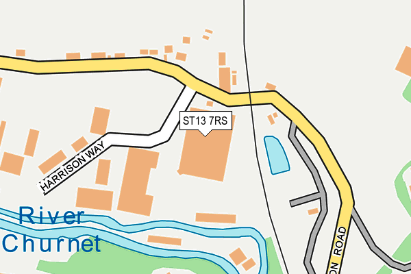
ST13 7RS is located in the Cheddleton electoral ward, within the local authority district of Staffordshire Moorlands and the English Parliamentary constituency of Staffordshire Moorlands. The Sub Integrated Care Board (ICB) Location is NHS Staffordshire and Stoke-on-Trent ICB - 05G and the police force is Staffordshire. This postcode has been in use since August 1992.


GetTheData
Source: OS OpenMap – Local (Ordnance Survey)
Source: OS VectorMap District (Ordnance Survey)
Licence: Open Government Licence (requires attribution)
| Easting | 398030 |
| Northing | 352495 |
| Latitude | 53.069688 |
| Longitude | -2.030853 |
GetTheData
Source: Open Postcode Geo
Licence: Open Government Licence
| Country | England |
| Postcode District | ST13 |
➜ See where ST13 is on a map ➜ Where is Cheddleton? | |
GetTheData
Source: Land Registry Price Paid Data
Licence: Open Government Licence
Elevation or altitude of ST13 7RS as distance above sea level:
| Metres | Feet | |
|---|---|---|
| Elevation | 140m | 459ft |
Elevation is measured from the approximate centre of the postcode, to the nearest point on an OS contour line from OS Terrain 50, which has contour spacing of ten vertical metres.
➜ How high above sea level am I? Find the elevation of your current position using your device's GPS.
GetTheData
Source: Open Postcode Elevation
Licence: Open Government Licence
| Ward | Cheddleton |
| Constituency | Staffordshire Moorlands |
GetTheData
Source: ONS Postcode Database
Licence: Open Government Licence
| Harrison Way (Station Road) | Cheddleton | 98m |
| Rail Station (Basford Bridge Lane) | Cheddleton | 429m |
| Railway Station (Basfordbridge Lane) | Cheddleton | 444m |
| Ashcombe Centre (Leek Rd) | Cheddleton | 695m |
| Station Road (Leek Rd) | Cheddleton | 707m |
| Cheddleton (Churnet Valley Railway) | Cheddleton | 499m |
GetTheData
Source: NaPTAN
Licence: Open Government Licence
GetTheData
Source: ONS Postcode Database
Licence: Open Government Licence


➜ Get more ratings from the Food Standards Agency
GetTheData
Source: Food Standards Agency
Licence: FSA terms & conditions
| Last Collection | |||
|---|---|---|---|
| Location | Mon-Fri | Sat | Distance |
| Cheddleton Post Office | 17:15 | 11:00 | 741m |
| Grange Road | 16:00 | 09:00 | 852m |
| Basford Bridge Lane | 12:00 | 09:00 | 949m |
GetTheData
Source: Dracos
Licence: Creative Commons Attribution-ShareAlike
| Risk of ST13 7RS flooding from rivers and sea | Medium |
| ➜ ST13 7RS flood map | |
GetTheData
Source: Open Flood Risk by Postcode
Licence: Open Government Licence
The below table lists the International Territorial Level (ITL) codes (formerly Nomenclature of Territorial Units for Statistics (NUTS) codes) and Local Administrative Units (LAU) codes for ST13 7RS:
| ITL 1 Code | Name |
|---|---|
| TLG | West Midlands (England) |
| ITL 2 Code | Name |
| TLG2 | Shropshire and Staffordshire |
| ITL 3 Code | Name |
| TLG24 | Staffordshire CC |
| LAU 1 Code | Name |
| E07000198 | Staffordshire Moorlands |
GetTheData
Source: ONS Postcode Directory
Licence: Open Government Licence
The below table lists the Census Output Area (OA), Lower Layer Super Output Area (LSOA), and Middle Layer Super Output Area (MSOA) for ST13 7RS:
| Code | Name | |
|---|---|---|
| OA | E00151809 | |
| LSOA | E01029792 | Staffordshire Moorlands 006A |
| MSOA | E02006209 | Staffordshire Moorlands 006 |
GetTheData
Source: ONS Postcode Directory
Licence: Open Government Licence
| ST13 7EE | Station Road | 230m |
| ST13 7NT | Kingsley View | 238m |
| ST13 7EW | Haigh Close | 346m |
| ST13 7NS | Cheddleton Park Avenue | 364m |
| ST13 7EP | Churnet Grange | 368m |
| ST13 7EN | Steele Close | 375m |
| ST13 7EH | Brittain Road | 384m |
| ST13 7EG | Basford Bridge Terrace | 392m |
| ST13 7LL | Vale View | 397m |
| ST13 7EL | Cauldon Avenue | 414m |
GetTheData
Source: Open Postcode Geo; Land Registry Price Paid Data
Licence: Open Government Licence