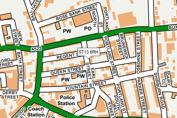
ST13 6RH is located in the Leek East electoral ward, within the local authority district of Staffordshire Moorlands and the English Parliamentary constituency of Staffordshire Moorlands. The Sub Integrated Care Board (ICB) Location is NHS Staffordshire and Stoke-on-Trent ICB - 05G and the police force is Staffordshire. This postcode has been in use since June 2017.


GetTheData
Source: OS OpenMap – Local (Ordnance Survey)
Source: OS VectorMap District (Ordnance Survey)
Licence: Open Government Licence (requires attribution)
| Easting | 398865 |
| Northing | 356614 |
| Latitude | 53.106734 |
| Longitude | -2.018404 |
GetTheData
Source: Open Postcode Geo
Licence: Open Government Licence
| Country | England |
| Postcode District | ST13 |
➜ See where ST13 is on a map ➜ Where is Leek? | |
GetTheData
Source: Land Registry Price Paid Data
Licence: Open Government Licence
| Ward | Leek East |
| Constituency | Staffordshire Moorlands |
GetTheData
Source: ONS Postcode Database
Licence: Open Government Licence
| Moorland Medical Centre (Buxton Rd) | Leek | 98m |
| Moorland Medical Centre (Buxton Rd) | Leek | 133m |
| Rose Bank Street (Ball Haye Rd) | Leek | 184m |
| Rose Bank Street (Ball Haye Rd) | Leek | 207m |
| Osborne Street (Buxton Road) | Leek | 208m |
GetTheData
Source: NaPTAN
Licence: Open Government Licence
| Percentage of properties with Next Generation Access | 100.0% |
| Percentage of properties with Superfast Broadband | 100.0% |
| Percentage of properties with Ultrafast Broadband | 0.0% |
| Percentage of properties with Full Fibre Broadband | 0.0% |
Superfast Broadband is between 30Mbps and 300Mbps
Ultrafast Broadband is > 300Mbps
| Percentage of properties unable to receive 2Mbps | 0.0% |
| Percentage of properties unable to receive 5Mbps | 0.0% |
| Percentage of properties unable to receive 10Mbps | 0.0% |
| Percentage of properties unable to receive 30Mbps | 0.0% |
GetTheData
Source: Ofcom
Licence: Ofcom Terms of Use (requires attribution)
GetTheData
Source: ONS Postcode Database
Licence: Open Government Licence


➜ Get more ratings from the Food Standards Agency
GetTheData
Source: Food Standards Agency
Licence: FSA terms & conditions
| Last Collection | |||
|---|---|---|---|
| Location | Mon-Fri | Sat | Distance |
| Leek Post Office | 17:15 | 12:00 | 123m |
| Shirburn Road | 16:30 | 11:00 | 235m |
| Brooklands | 16:30 | 11:00 | 244m |
GetTheData
Source: Dracos
Licence: Creative Commons Attribution-ShareAlike
The below table lists the International Territorial Level (ITL) codes (formerly Nomenclature of Territorial Units for Statistics (NUTS) codes) and Local Administrative Units (LAU) codes for ST13 6RH:
| ITL 1 Code | Name |
|---|---|
| TLG | West Midlands (England) |
| ITL 2 Code | Name |
| TLG2 | Shropshire and Staffordshire |
| ITL 3 Code | Name |
| TLG24 | Staffordshire CC |
| LAU 1 Code | Name |
| E07000198 | Staffordshire Moorlands |
GetTheData
Source: ONS Postcode Directory
Licence: Open Government Licence
The below table lists the Census Output Area (OA), Lower Layer Super Output Area (LSOA), and Middle Layer Super Output Area (MSOA) for ST13 6RH:
| Code | Name | |
|---|---|---|
| OA | E00151884 | |
| LSOA | E01029804 | Staffordshire Moorlands 005A |
| MSOA | E02006208 | Staffordshire Moorlands 005 |
GetTheData
Source: ONS Postcode Directory
Licence: Open Government Licence
| ST13 6LP | Queen Street | 46m |
| ST13 6LX | Regent Street | 51m |
| ST13 6JT | Earl Street | 62m |
| ST13 6EE | Buxton Road | 73m |
| ST13 6JS | Fountain Street | 74m |
| ST13 6LU | Regent Street | 79m |
| ST13 6LS | Queen Street | 97m |
| ST13 6JZ | Portland Street | 100m |
| ST13 6JR | Fountain Street | 102m |
| ST13 6LY | Portland Street | 106m |
GetTheData
Source: Open Postcode Geo; Land Registry Price Paid Data
Licence: Open Government Licence