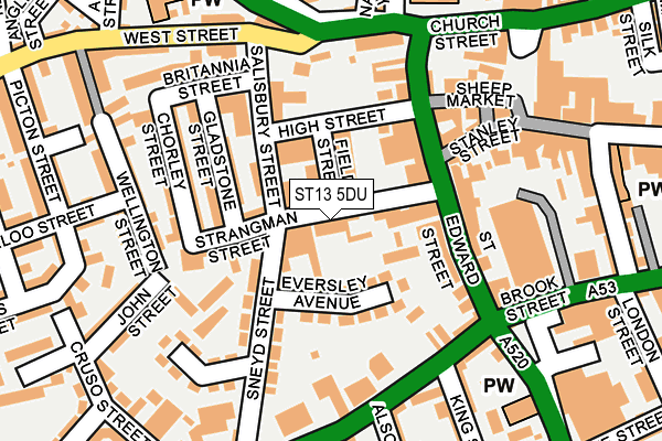
ST13 5DU is located in the Leek South electoral ward, within the local authority district of Staffordshire Moorlands and the English Parliamentary constituency of Staffordshire Moorlands. The Sub Integrated Care Board (ICB) Location is NHS Staffordshire and Stoke-on-Trent ICB - 05G and the police force is Staffordshire. This postcode has been in use since January 1980.


GetTheData
Source: OS OpenMap – Local (Ordnance Survey)
Source: OS VectorMap District (Ordnance Survey)
Licence: Open Government Licence (requires attribution)
| Easting | 398234 |
| Northing | 356457 |
| Latitude | 53.105321 |
| Longitude | -2.027829 |
GetTheData
Source: Open Postcode Geo
Licence: Open Government Licence
| Country | England |
| Postcode District | ST13 |
➜ See where ST13 is on a map ➜ Where is Leek? | |
GetTheData
Source: Land Registry Price Paid Data
Licence: Open Government Licence
Elevation or altitude of ST13 5DU as distance above sea level:
| Metres | Feet | |
|---|---|---|
| Elevation | 180m | 591ft |
Elevation is measured from the approximate centre of the postcode, to the nearest point on an OS contour line from OS Terrain 50, which has contour spacing of ten vertical metres.
➜ How high above sea level am I? Find the elevation of your current position using your device's GPS.
GetTheData
Source: Open Postcode Elevation
Licence: Open Government Licence
| Ward | Leek South |
| Constituency | Staffordshire Moorlands |
GetTheData
Source: ONS Postcode Database
Licence: Open Government Licence
| Salisbury Street (West St) | Leek Town Centre | 154m |
| Salisbury Street (West St) | Leek Town Centre | 175m |
| King Street (Broad St) | Leek Town Centre | 178m |
| King Street (Broad St) | Leek Town Centre | 193m |
| Sneyd Street (Broad St) | Leek Town Centre | 232m |
GetTheData
Source: NaPTAN
Licence: Open Government Licence
Estimated total energy consumption in ST13 5DU by fuel type, 2015.
| Consumption (kWh) | 130,574 |
|---|---|
| Meter count | 6 |
| Mean (kWh/meter) | 21,762 |
| Median (kWh/meter) | 16,375 |
GetTheData
Source: Postcode level gas estimates: 2015 (experimental)
Source: Postcode level electricity estimates: 2015 (experimental)
Licence: Open Government Licence
GetTheData
Source: ONS Postcode Database
Licence: Open Government Licence


➜ Get more ratings from the Food Standards Agency
GetTheData
Source: Food Standards Agency
Licence: FSA terms & conditions
| Last Collection | |||
|---|---|---|---|
| Location | Mon-Fri | Sat | Distance |
| St Edward Street | 18:00 | 12:15 | 86m |
| Derby Street | 18:00 | 12:00 | 207m |
| Market Place | 18:00 | 11:00 | 211m |
GetTheData
Source: Dracos
Licence: Creative Commons Attribution-ShareAlike
The below table lists the International Territorial Level (ITL) codes (formerly Nomenclature of Territorial Units for Statistics (NUTS) codes) and Local Administrative Units (LAU) codes for ST13 5DU:
| ITL 1 Code | Name |
|---|---|
| TLG | West Midlands (England) |
| ITL 2 Code | Name |
| TLG2 | Shropshire and Staffordshire |
| ITL 3 Code | Name |
| TLG24 | Staffordshire CC |
| LAU 1 Code | Name |
| E07000198 | Staffordshire Moorlands |
GetTheData
Source: ONS Postcode Directory
Licence: Open Government Licence
The below table lists the Census Output Area (OA), Lower Layer Super Output Area (LSOA), and Middle Layer Super Output Area (MSOA) for ST13 5DU:
| Code | Name | |
|---|---|---|
| OA | E00151916 | |
| LSOA | E01029812 | Staffordshire Moorlands 005D |
| MSOA | E02006208 | Staffordshire Moorlands 005 |
GetTheData
Source: ONS Postcode Directory
Licence: Open Government Licence
| ST13 5DY | Field Street | 24m |
| ST13 5DX | Strangman Street | 39m |
| ST13 5EE | Salisbury Street | 78m |
| ST13 5HS | Eversley Avenue | 93m |
| ST13 5EF | Strangman Street | 95m |
| ST13 5DS | St Edward Street | 96m |
| ST13 5ES | Overton Bank | 119m |
| ST13 5DR | St Edward Street | 120m |
| ST13 5DL | St Edward Street | 121m |
| ST13 5EP | Gladstone Street | 122m |
GetTheData
Source: Open Postcode Geo; Land Registry Price Paid Data
Licence: Open Government Licence