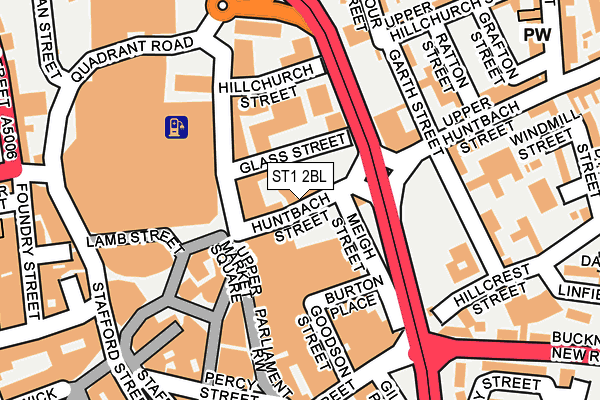
ST1 2BL lies on Huntbach Street in Stoke-on-trent. ST1 2BL is located in the Etruria & Hanley electoral ward, within the unitary authority of Stoke-on-Trent and the English Parliamentary constituency of Stoke-on-Trent Central. The Sub Integrated Care Board (ICB) Location is NHS Staffordshire and Stoke-on-Trent ICB - 05W and the police force is Staffordshire. This postcode has been in use since January 1980.


GetTheData
Source: OS OpenMap – Local (Ordnance Survey)
Source: OS VectorMap District (Ordnance Survey)
Licence: Open Government Licence (requires attribution)
| Easting | 388464 |
| Northing | 347752 |
| Latitude | 53.026930 |
| Longitude | -2.173448 |
GetTheData
Source: Open Postcode Geo
Licence: Open Government Licence
| Street | Huntbach Street |
| Town/City | Stoke-on-trent |
| Country | England |
| Postcode District | ST1 |
➜ See where ST1 is on a map ➜ Where is Stoke-on-Trent? | |
GetTheData
Source: Land Registry Price Paid Data
Licence: Open Government Licence
Elevation or altitude of ST1 2BL as distance above sea level:
| Metres | Feet | |
|---|---|---|
| Elevation | 170m | 558ft |
Elevation is measured from the approximate centre of the postcode, to the nearest point on an OS contour line from OS Terrain 50, which has contour spacing of ten vertical metres.
➜ How high above sea level am I? Find the elevation of your current position using your device's GPS.
GetTheData
Source: Open Postcode Elevation
Licence: Open Government Licence
| Ward | Etruria & Hanley |
| Constituency | Stoke-on-trent Central |
GetTheData
Source: ONS Postcode Database
Licence: Open Government Licence
15, HUNTBACH STREET, STOKE-ON-TRENT, ST1 2BL 1999 19 AUG £160,000 |
GetTheData
Source: HM Land Registry Price Paid Data
Licence: Contains HM Land Registry data © Crown copyright and database right 2025. This data is licensed under the Open Government Licence v3.0.
| Stop O 1 (Old Hall Street) | Hanley | 195m |
| Stop Q2 (Quadrant Road) | Hanley | 209m |
| Stop S3 (Stafford Street) | Hanley | 218m |
| Upper Huntbach Street | Hanley | 219m |
| Upper Huntbach Street | Hanley | 219m |
| Stoke-on-Trent Station | 2.2km |
| Longport Station | 3.3km |
| Longton Station | 4.8km |
GetTheData
Source: NaPTAN
Licence: Open Government Licence
Estimated total energy consumption in ST1 2BL by fuel type, 2015.
| Consumption (kWh) | 44,415 |
|---|---|
| Meter count | 6 |
| Mean (kWh/meter) | 7,403 |
| Median (kWh/meter) | 4,453 |
GetTheData
Source: Postcode level gas estimates: 2015 (experimental)
Source: Postcode level electricity estimates: 2015 (experimental)
Licence: Open Government Licence
GetTheData
Source: ONS Postcode Database
Licence: Open Government Licence


➜ Get more ratings from the Food Standards Agency
GetTheData
Source: Food Standards Agency
Licence: FSA terms & conditions
| Last Collection | |||
|---|---|---|---|
| Location | Mon-Fri | Sat | Distance |
| Market Square | 18:15 | 12:30 | 148m |
| Garth Street | 17:30 | 10:30 | 154m |
| East Precinct | 18:00 | 12:00 | 248m |
GetTheData
Source: Dracos
Licence: Creative Commons Attribution-ShareAlike
The below table lists the International Territorial Level (ITL) codes (formerly Nomenclature of Territorial Units for Statistics (NUTS) codes) and Local Administrative Units (LAU) codes for ST1 2BL:
| ITL 1 Code | Name |
|---|---|
| TLG | West Midlands (England) |
| ITL 2 Code | Name |
| TLG2 | Shropshire and Staffordshire |
| ITL 3 Code | Name |
| TLG23 | Stoke-on-Trent |
| LAU 1 Code | Name |
| E06000021 | Stoke-on-Trent |
GetTheData
Source: ONS Postcode Directory
Licence: Open Government Licence
The below table lists the Census Output Area (OA), Lower Layer Super Output Area (LSOA), and Middle Layer Super Output Area (MSOA) for ST1 2BL:
| Code | Name | |
|---|---|---|
| OA | E00072125 | |
| LSOA | E01014287 | Stoke-on-Trent 015D |
| MSOA | E02002965 | Stoke-on-Trent 015 |
GetTheData
Source: ONS Postcode Directory
Licence: Open Government Licence
| ST1 2JE | Town Road | 51m |
| ST1 1NS | Upper Market Square | 102m |
| ST1 2JQ | Town Road | 107m |
| ST1 2EZ | Hillchurch Street | 147m |
| ST1 1QD | Parliament Row | 151m |
| ST1 3AU | Old Hall Street | 170m |
| ST1 1PS | Potteries Shopping Centre | 173m |
| ST1 1NP | Tontine Square | 173m |
| ST1 2HD | Upper Hillchurch Street | 178m |
| ST1 1NQ | Tontine Street | 181m |
GetTheData
Source: Open Postcode Geo; Land Registry Price Paid Data
Licence: Open Government Licence