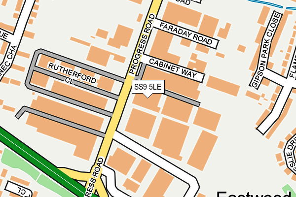
SS9 5LE is located in the Eastwood Park electoral ward, within the unitary authority of Southend-on-Sea and the English Parliamentary constituency of Southend West. The Sub Integrated Care Board (ICB) Location is NHS Mid and South Essex ICB - 99G and the police force is Essex. This postcode has been in use since January 1980.


GetTheData
Source: OS OpenMap – Local (Ordnance Survey)
Source: OS VectorMap District (Ordnance Survey)
Licence: Open Government Licence (requires attribution)
| Easting | 583317 |
| Northing | 188785 |
| Latitude | 51.568134 |
| Longitude | 0.643656 |
GetTheData
Source: Open Postcode Geo
Licence: Open Government Licence
| Country | England |
| Postcode District | SS9 |
➜ See where SS9 is on a map ➜ Where is Southend-on-Sea? | |
GetTheData
Source: Land Registry Price Paid Data
Licence: Open Government Licence
Elevation or altitude of SS9 5LE as distance above sea level:
| Metres | Feet | |
|---|---|---|
| Elevation | 40m | 131ft |
Elevation is measured from the approximate centre of the postcode, to the nearest point on an OS contour line from OS Terrain 50, which has contour spacing of ten vertical metres.
➜ How high above sea level am I? Find the elevation of your current position using your device's GPS.
GetTheData
Source: Open Postcode Elevation
Licence: Open Government Licence
| Ward | Eastwood Park |
| Constituency | Southend West |
GetTheData
Source: ONS Postcode Database
Licence: Open Government Licence
| Progress Road (Rayleigh Road) | Eastwood | 324m |
| Progress Road (Rayleigh Road) | Eastwood | 349m |
| Eastwood Old Road Shops (Eastwood Old Road) | Belfairs | 384m |
| Eastwood Old Road Shops (Eastwood Old Road) | Belfairs | 394m |
| Belfairs Park Drive (The Fairway) | Belfairs | 410m |
| Leigh-on-Sea Station | 3km |
| Chalkwell Station | 3.8km |
| Rayleigh Station | 3.8km |
GetTheData
Source: NaPTAN
Licence: Open Government Licence
GetTheData
Source: ONS Postcode Database
Licence: Open Government Licence


➜ Get more ratings from the Food Standards Agency
GetTheData
Source: Food Standards Agency
Licence: FSA terms & conditions
| Last Collection | |||
|---|---|---|---|
| Location | Mon-Fri | Sat | Distance |
| Progress Road | 17:30 | 11:30 | 325m |
| Rothwell Road | 17:30 | 11:30 | 398m |
| Ringwood Drive | 17:30 | 11:30 | 483m |
GetTheData
Source: Dracos
Licence: Creative Commons Attribution-ShareAlike
The below table lists the International Territorial Level (ITL) codes (formerly Nomenclature of Territorial Units for Statistics (NUTS) codes) and Local Administrative Units (LAU) codes for SS9 5LE:
| ITL 1 Code | Name |
|---|---|
| TLH | East |
| ITL 2 Code | Name |
| TLH3 | Essex |
| ITL 3 Code | Name |
| TLH31 | Southend-on-Sea |
| LAU 1 Code | Name |
| E06000033 | Southend-on-Sea |
GetTheData
Source: ONS Postcode Directory
Licence: Open Government Licence
The below table lists the Census Output Area (OA), Lower Layer Super Output Area (LSOA), and Middle Layer Super Output Area (MSOA) for SS9 5LE:
| Code | Name | |
|---|---|---|
| OA | E00080056 | |
| LSOA | E01015834 | Southend-on-Sea 001B |
| MSOA | E02003279 | Southend-on-Sea 001 |
GetTheData
Source: ONS Postcode Directory
Licence: Open Government Licence
| SS9 5LQ | Rutherford Close | 136m |
| SS9 5NS | Leighfields Road | 244m |
| SS9 5PW | Gipson Park Close | 270m |
| SS9 5EW | Cornec Chase | 284m |
| SS9 5NT | Flamboro Close | 310m |
| SS9 5NW | Leslie Drive | 324m |
| SS9 4DR | Arterial Road | 325m |
| SS9 5EP | Bowman Avenue | 328m |
| SS9 4RU | The Fairway | 329m |
| SS9 5EN | Cornec Avenue | 335m |
GetTheData
Source: Open Postcode Geo; Land Registry Price Paid Data
Licence: Open Government Licence