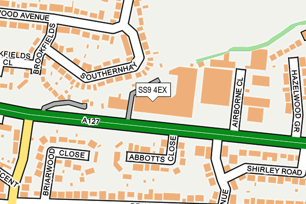
SS9 4EX is located in the Eastwood Park electoral ward, within the unitary authority of Southend-on-Sea and the English Parliamentary constituency of Southend West. The Sub Integrated Care Board (ICB) Location is NHS Mid and South Essex ICB - 99G and the police force is Essex. This postcode has been in use since August 1992.


GetTheData
Source: OS OpenMap – Local (Ordnance Survey)
Source: OS VectorMap District (Ordnance Survey)
Licence: Open Government Licence (requires attribution)
| Easting | 584092 |
| Northing | 188320 |
| Latitude | 51.563705 |
| Longitude | 0.654583 |
GetTheData
Source: Open Postcode Geo
Licence: Open Government Licence
| Country | England |
| Postcode District | SS9 |
➜ See where SS9 is on a map ➜ Where is Southend-on-Sea? | |
GetTheData
Source: Land Registry Price Paid Data
Licence: Open Government Licence
Elevation or altitude of SS9 4EX as distance above sea level:
| Metres | Feet | |
|---|---|---|
| Elevation | 30m | 98ft |
Elevation is measured from the approximate centre of the postcode, to the nearest point on an OS contour line from OS Terrain 50, which has contour spacing of ten vertical metres.
➜ How high above sea level am I? Find the elevation of your current position using your device's GPS.
GetTheData
Source: Open Postcode Elevation
Licence: Open Government Licence
| Ward | Eastwood Park |
| Constituency | Southend West |
GetTheData
Source: ONS Postcode Database
Licence: Open Government Licence
| Coombes Corner (Eastwood Road North) | Leigh-on-sea | 396m |
| Coombes Corner (Eastwood Road North) | Leigh-on-sea | 404m |
| Coombes Corner (Elmsleigh Drive) | Leigh-on-sea | 448m |
| Coombes Corner (Elmsleigh Drive) | Leigh-on-sea | 457m |
| Danesleigh Gardens (Eastwood Road North) | Belfairs | 480m |
| Leigh-on-Sea Station | 2.7km |
| Chalkwell Station | 3km |
| Southend Airport Station | 3.5km |
GetTheData
Source: NaPTAN
Licence: Open Government Licence
GetTheData
Source: ONS Postcode Database
Licence: Open Government Licence


➜ Get more ratings from the Food Standards Agency
GetTheData
Source: Food Standards Agency
Licence: FSA terms & conditions
| Last Collection | |||
|---|---|---|---|
| Location | Mon-Fri | Sat | Distance |
| Briarwood Drive | 17:30 | 11:30 | 311m |
| Pinewood Avenue | 17:30 | 11:30 | 354m |
| Bellhouse Road | 17:30 | 11:30 | 380m |
GetTheData
Source: Dracos
Licence: Creative Commons Attribution-ShareAlike
The below table lists the International Territorial Level (ITL) codes (formerly Nomenclature of Territorial Units for Statistics (NUTS) codes) and Local Administrative Units (LAU) codes for SS9 4EX:
| ITL 1 Code | Name |
|---|---|
| TLH | East |
| ITL 2 Code | Name |
| TLH3 | Essex |
| ITL 3 Code | Name |
| TLH31 | Southend-on-Sea |
| LAU 1 Code | Name |
| E06000033 | Southend-on-Sea |
GetTheData
Source: ONS Postcode Directory
Licence: Open Government Licence
The below table lists the Census Output Area (OA), Lower Layer Super Output Area (LSOA), and Middle Layer Super Output Area (MSOA) for SS9 4EX:
| Code | Name | |
|---|---|---|
| OA | E00080062 | |
| LSOA | E01015835 | Southend-on-Sea 001C |
| MSOA | E02003279 | Southend-on-Sea 001 |
GetTheData
Source: ONS Postcode Directory
Licence: Open Government Licence
| SS9 5PF | Southernhay | 91m |
| SS9 4DQ | Abbotts Close | 102m |
| SS9 4DH | Arterial Road | 120m |
| SS9 5PE | Southernhay | 121m |
| SS9 4DG | Arterial Road | 175m |
| SS9 4LB | Briarwood Drive | 193m |
| SS9 4JX | Oakwood Avenue | 215m |
| SS9 4LE | Briarwood Close | 216m |
| SS9 5PG | Brookfields | 222m |
| SS9 5PB | Pinewood Avenue | 225m |
GetTheData
Source: Open Postcode Geo; Land Registry Price Paid Data
Licence: Open Government Licence