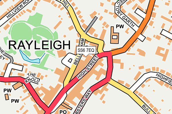
SS6 7EQ is located in the Wheatley electoral ward, within the local authority district of Rochford and the English Parliamentary constituency of Rayleigh and Wickford. The Sub Integrated Care Board (ICB) Location is NHS Mid and South Essex ICB - 99F and the police force is Essex. This postcode has been in use since January 1980.


GetTheData
Source: OS OpenMap – Local (Ordnance Survey)
Source: OS VectorMap District (Ordnance Survey)
Licence: Open Government Licence (requires attribution)
| Easting | 580716 |
| Northing | 190867 |
| Latitude | 51.587674 |
| Longitude | 0.607240 |
GetTheData
Source: Open Postcode Geo
Licence: Open Government Licence
| Country | England |
| Postcode District | SS6 |
➜ See where SS6 is on a map ➜ Where is Rayleigh? | |
GetTheData
Source: Land Registry Price Paid Data
Licence: Open Government Licence
Elevation or altitude of SS6 7EQ as distance above sea level:
| Metres | Feet | |
|---|---|---|
| Elevation | 70m | 230ft |
Elevation is measured from the approximate centre of the postcode, to the nearest point on an OS contour line from OS Terrain 50, which has contour spacing of ten vertical metres.
➜ How high above sea level am I? Find the elevation of your current position using your device's GPS.
GetTheData
Source: Open Postcode Elevation
Licence: Open Government Licence
| Ward | Wheatley |
| Constituency | Rayleigh And Wickford |
GetTheData
Source: ONS Postcode Database
Licence: Open Government Licence
| Bull Lane (Websters Way) | Rayleigh | 105m |
| High Street | Rayleigh | 157m |
| High Street | Rayleigh | 171m |
| Church (Hockley Road) | Rayleigh | 185m |
| Bull Lane | Rayleigh | 187m |
| Rayleigh Station | 0.5km |
| Hockley Station | 4km |
| Battlesbridge Station | 5.1km |
GetTheData
Source: NaPTAN
Licence: Open Government Licence
GetTheData
Source: ONS Postcode Database
Licence: Open Government Licence
➜ Get more ratings from the Food Standards Agency
GetTheData
Source: Food Standards Agency
Licence: FSA terms & conditions
| Last Collection | |||
|---|---|---|---|
| Location | Mon-Fri | Sat | Distance |
| High Street Church | 17:30 | 12:30 | 30m |
| Station Road Post Office | 17:15 | 12:15 | 469m |
| The Approach | 17:15 | 12:00 | 489m |
GetTheData
Source: Dracos
Licence: Creative Commons Attribution-ShareAlike
The below table lists the International Territorial Level (ITL) codes (formerly Nomenclature of Territorial Units for Statistics (NUTS) codes) and Local Administrative Units (LAU) codes for SS6 7EQ:
| ITL 1 Code | Name |
|---|---|
| TLH | East |
| ITL 2 Code | Name |
| TLH3 | Essex |
| ITL 3 Code | Name |
| TLH37 | Essex Thames Gateway |
| LAU 1 Code | Name |
| E07000075 | Rochford |
GetTheData
Source: ONS Postcode Directory
Licence: Open Government Licence
The below table lists the Census Output Area (OA), Lower Layer Super Output Area (LSOA), and Middle Layer Super Output Area (MSOA) for SS6 7EQ:
| Code | Name | |
|---|---|---|
| OA | E00111558 | |
| LSOA | E01021964 | Rochford 008E |
| MSOA | E02004570 | Rochford 008 |
GetTheData
Source: ONS Postcode Directory
Licence: Open Government Licence
| SS6 7EF | High Street | 33m |
| SS6 7ED | Bellingham Lane | 39m |
| SS6 7PP | High Street | 57m |
| SS6 7EW | High Street | 63m |
| SS6 7EE | Church Street | 66m |
| SS6 7HN | Bellingham Lane | 86m |
| SS6 8JQ | Websters Way | 135m |
| SS6 7EA | High Street | 140m |
| SS6 8JF | Bull Lane | 144m |
| SS6 8BA | Hockley Road | 169m |
GetTheData
Source: Open Postcode Geo; Land Registry Price Paid Data
Licence: Open Government Licence