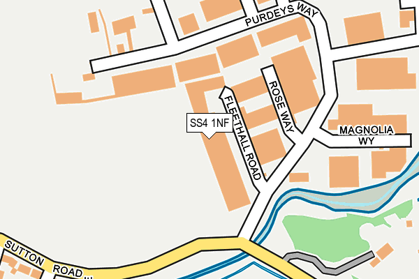
SS4 1NF is located in the Roche South electoral ward, within the local authority district of Rochford and the English Parliamentary constituency of Rochford and Southend East. The Sub Integrated Care Board (ICB) Location is NHS Mid and South Essex ICB - 99F and the police force is Essex. This postcode has been in use since January 1980.


GetTheData
Source: OS OpenMap – Local (Ordnance Survey)
Source: OS VectorMap District (Ordnance Survey)
Licence: Open Government Licence (requires attribution)
| Easting | 588271 |
| Northing | 189790 |
| Latitude | 51.575529 |
| Longitude | 0.715590 |
GetTheData
Source: Open Postcode Geo
Licence: Open Government Licence
| Country | England |
| Postcode District | SS4 |
➜ See where SS4 is on a map ➜ Where is Rochford? | |
GetTheData
Source: Land Registry Price Paid Data
Licence: Open Government Licence
Elevation or altitude of SS4 1NF as distance above sea level:
| Metres | Feet | |
|---|---|---|
| Elevation | 10m | 33ft |
Elevation is measured from the approximate centre of the postcode, to the nearest point on an OS contour line from OS Terrain 50, which has contour spacing of ten vertical metres.
➜ How high above sea level am I? Find the elevation of your current position using your device's GPS.
GetTheData
Source: Open Postcode Elevation
Licence: Open Government Licence
| Ward | Roche South |
| Constituency | Rochford And Southend East |
GetTheData
Source: ONS Postcode Database
Licence: Open Government Licence
| Purdeys Way (Sutton Road) | Rochford | 146m |
| Purdeys Way (Sutton Road) | Rochford | 152m |
| Sutton Court Drive (Sutton Road) | Rochford | 545m |
| Sutton Court Drive (Sutton Road) | Rochford | 550m |
| The Anne Boleyn (Southend Road) | Rochford | 627m |
| Southend Airport Station | 1.1km |
| Rochford Station | 1.2km |
| Prittlewell Station | 2.8km |
GetTheData
Source: NaPTAN
Licence: Open Government Licence
GetTheData
Source: ONS Postcode Database
Licence: Open Government Licence


➜ Get more ratings from the Food Standards Agency
GetTheData
Source: Food Standards Agency
Licence: FSA terms & conditions
| Last Collection | |||
|---|---|---|---|
| Location | Mon-Fri | Sat | Distance |
| Shopland Road | 17:30 | 08:00 | 622m |
| Queensland Avenue | 17:30 | 12:30 | 832m |
| 14 West Street P.o. | 17:30 | 12:00 | 1,012m |
GetTheData
Source: Dracos
Licence: Creative Commons Attribution-ShareAlike
The below table lists the International Territorial Level (ITL) codes (formerly Nomenclature of Territorial Units for Statistics (NUTS) codes) and Local Administrative Units (LAU) codes for SS4 1NF:
| ITL 1 Code | Name |
|---|---|
| TLH | East |
| ITL 2 Code | Name |
| TLH3 | Essex |
| ITL 3 Code | Name |
| TLH37 | Essex Thames Gateway |
| LAU 1 Code | Name |
| E07000075 | Rochford |
GetTheData
Source: ONS Postcode Directory
Licence: Open Government Licence
The below table lists the Census Output Area (OA), Lower Layer Super Output Area (LSOA), and Middle Layer Super Output Area (MSOA) for SS4 1NF:
| Code | Name | |
|---|---|---|
| OA | E00111507 | |
| LSOA | E01021956 | Rochford 007E |
| MSOA | E02004569 | Rochford 007 |
GetTheData
Source: ONS Postcode Directory
Licence: Open Government Licence
| SS4 1LY | Rose Way | 84m |
| SS4 1ND | Purdeys Way | 160m |
| SS4 1LD | Featherby Way | 230m |
| SS4 1NE | Purdeys Way | 263m |
| SS4 1HL | Sutton Road | 293m |
| SS4 1HN | Brook Close | 345m |
| SS4 1LE | Sutton Ford Cottages | 351m |
| SS4 1LB | Rocheview Business Park | 386m |
| SS4 1HS | Sutton Court Drive | 431m |
| SS4 1HJ | Sutton Road | 437m |
GetTheData
Source: Open Postcode Geo; Land Registry Price Paid Data
Licence: Open Government Licence