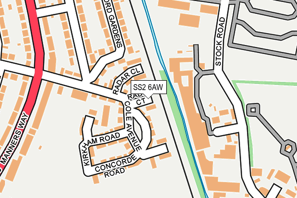
SS2 6AW is located in the St Laurence electoral ward, within the unitary authority of Southend-on-Sea and the English Parliamentary constituency of Southend West. The Sub Integrated Care Board (ICB) Location is NHS Mid and South Essex ICB - 99G and the police force is Essex. This postcode has been in use since March 2017.


GetTheData
Source: OS OpenMap – Local (Ordnance Survey)
Source: OS VectorMap District (Ordnance Survey)
Licence: Open Government Licence (requires attribution)
| Easting | 587709 |
| Northing | 187942 |
| Latitude | 51.559124 |
| Longitude | 0.706532 |
GetTheData
Source: Open Postcode Geo
Licence: Open Government Licence
| Country | England |
| Postcode District | SS2 |
➜ See where SS2 is on a map ➜ Where is Southend-on-Sea? | |
GetTheData
Source: Land Registry Price Paid Data
Licence: Open Government Licence
| Ward | St Laurence |
| Constituency | Southend West |
GetTheData
Source: ONS Postcode Database
Licence: Open Government Licence
| Keymed (Stock Road) | Temple Farm Ind Estate | 203m |
| Thornford Gardens (Manners Way) | Prittlewell | 228m |
| Thornford Gardens (Manners Way) | Prittlewell | 232m |
| Stock Close (Stock Road) | Temple Farm Ind Estate | 265m |
| Fdr House (Priory Crescent) | Prittlewell | 376m |
| Prittlewell Station | 1km |
| Southend Airport Station | 1.1km |
| Southend Victoria Station | 2km |
GetTheData
Source: NaPTAN
Licence: Open Government Licence
| Percentage of properties with Next Generation Access | 100.0% |
| Percentage of properties with Superfast Broadband | 100.0% |
| Percentage of properties with Ultrafast Broadband | 100.0% |
| Percentage of properties with Full Fibre Broadband | 100.0% |
Superfast Broadband is between 30Mbps and 300Mbps
Ultrafast Broadband is > 300Mbps
| Median download speed | 54.3Mbps |
| Average download speed | 53.2Mbps |
| Maximum download speed | 128.29Mbps |
| Median upload speed | 12.1Mbps |
| Average upload speed | 11.7Mbps |
| Maximum upload speed | 19.53Mbps |
| Percentage of properties unable to receive 2Mbps | 0.0% |
| Percentage of properties unable to receive 5Mbps | 0.0% |
| Percentage of properties unable to receive 10Mbps | 0.0% |
| Percentage of properties unable to receive 30Mbps | 0.0% |
GetTheData
Source: Ofcom
Licence: Ofcom Terms of Use (requires attribution)
GetTheData
Source: ONS Postcode Database
Licence: Open Government Licence


➜ Get more ratings from the Food Standards Agency
GetTheData
Source: Food Standards Agency
Licence: FSA terms & conditions
| Last Collection | |||
|---|---|---|---|
| Location | Mon-Fri | Sat | Distance |
| Thornford Gardens | 17:30 | 11:30 | 270m |
| Earls Hall Parade Post Office | 17:30 | 11:30 | 520m |
| Manners Way | 17:30 | 11:30 | 572m |
GetTheData
Source: Dracos
Licence: Creative Commons Attribution-ShareAlike
The below table lists the International Territorial Level (ITL) codes (formerly Nomenclature of Territorial Units for Statistics (NUTS) codes) and Local Administrative Units (LAU) codes for SS2 6AW:
| ITL 1 Code | Name |
|---|---|
| TLH | East |
| ITL 2 Code | Name |
| TLH3 | Essex |
| ITL 3 Code | Name |
| TLH31 | Southend-on-Sea |
| LAU 1 Code | Name |
| E06000033 | Southend-on-Sea |
GetTheData
Source: ONS Postcode Directory
Licence: Open Government Licence
The below table lists the Census Output Area (OA), Lower Layer Super Output Area (LSOA), and Middle Layer Super Output Area (MSOA) for SS2 6AW:
| Code | Name | |
|---|---|---|
| OA | E00080217 | |
| LSOA | E01015866 | Southend-on-Sea 002D |
| MSOA | E02003280 | Southend-on-Sea 002 |
GetTheData
Source: ONS Postcode Directory
Licence: Open Government Licence
| SS2 6PU | Thornford Gardens | 180m |
| SS2 6PY | Thornford Gardens | 239m |
| SS2 6PX | Thornford Gardens | 244m |
| SS2 5NN | Stock Road | 277m |
| SS2 6SE | Byrne Drive | 281m |
| SS2 6PT | Manners Way | 284m |
| SS2 6PZ | Manners Way | 297m |
| SS2 6QW | Manners Way | 309m |
| SS2 6QP | Manners Way | 318m |
| SS2 6SF | Aragon Close | 330m |
GetTheData
Source: Open Postcode Geo; Land Registry Price Paid Data
Licence: Open Government Licence