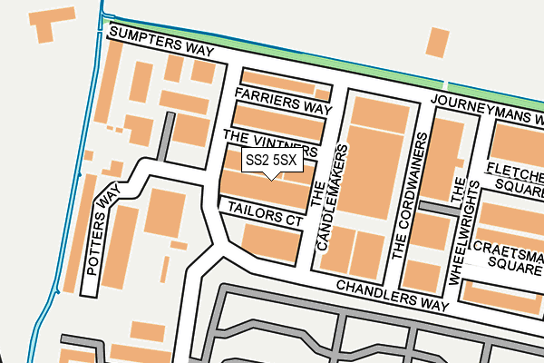
SS2 5SX lies on Tailors Court in Temple Farm Industrial Estate, Southend-on-sea. SS2 5SX is located in the St. Luke's electoral ward, within the unitary authority of Southend-on-Sea and the English Parliamentary constituency of Rochford and Southend East. The Sub Integrated Care Board (ICB) Location is NHS Mid and South Essex ICB - 99G and the police force is Essex. This postcode has been in use since March 1988.


GetTheData
Source: OS OpenMap – Local (Ordnance Survey)
Source: OS VectorMap District (Ordnance Survey)
Licence: Open Government Licence (requires attribution)
| Easting | 587974 |
| Northing | 188341 |
| Latitude | 51.562614 |
| Longitude | 0.710534 |
GetTheData
Source: Open Postcode Geo
Licence: Open Government Licence
| Street | Tailors Court |
| Locality | Temple Farm Industrial Estate |
| Town/City | Southend-on-sea |
| Country | England |
| Postcode District | SS2 |
➜ See where SS2 is on a map ➜ Where is Southend-on-Sea? | |
GetTheData
Source: Land Registry Price Paid Data
Licence: Open Government Licence
Elevation or altitude of SS2 5SX as distance above sea level:
| Metres | Feet | |
|---|---|---|
| Elevation | 10m | 33ft |
Elevation is measured from the approximate centre of the postcode, to the nearest point on an OS contour line from OS Terrain 50, which has contour spacing of ten vertical metres.
➜ How high above sea level am I? Find the elevation of your current position using your device's GPS.
GetTheData
Source: Open Postcode Elevation
Licence: Open Government Licence
| Ward | St. Luke's |
| Constituency | Rochford And Southend East |
GetTheData
Source: ONS Postcode Database
Licence: Open Government Licence
| The Candlemakers (Chandlers Way) | Temple Farm Ind Estate | 125m |
| Keymed (Stock Road) | Temple Farm Ind Estate | 286m |
| Coopers Way (Chandlers Way) | Temple Farm Ind Estate | 374m |
| Oaken Grange Drive (Manners Way) | Prittlewell | 553m |
| Thornford Gardens (Manners Way) | Prittlewell | 565m |
| Southend Airport Station | 0.8km |
| Prittlewell Station | 1.3km |
| Rochford Station | 2.2km |
GetTheData
Source: NaPTAN
Licence: Open Government Licence
| Median download speed | 74.0Mbps |
| Average download speed | 56.2Mbps |
| Maximum download speed | 80.00Mbps |
| Median upload speed | 20.0Mbps |
| Average upload speed | 14.2Mbps |
| Maximum upload speed | 20.00Mbps |
GetTheData
Source: Ofcom
Licence: Ofcom Terms of Use (requires attribution)
Estimated total energy consumption in SS2 5SX by fuel type, 2015.
| Consumption (kWh) | 129,741 |
|---|---|
| Meter count | 10 |
| Mean (kWh/meter) | 12,974 |
| Median (kWh/meter) | 5,784 |
GetTheData
Source: Postcode level gas estimates: 2015 (experimental)
Source: Postcode level electricity estimates: 2015 (experimental)
Licence: Open Government Licence
GetTheData
Source: ONS Postcode Database
Licence: Open Government Licence


➜ Get more ratings from the Food Standards Agency
GetTheData
Source: Food Standards Agency
Licence: FSA terms & conditions
| Last Collection | |||
|---|---|---|---|
| Location | Mon-Fri | Sat | Distance |
| Chandlers Way | 18:30 | 11:30 | 331m |
| Thornford Gardens | 17:30 | 11:30 | 538m |
| Manners Way | 17:30 | 11:30 | 568m |
GetTheData
Source: Dracos
Licence: Creative Commons Attribution-ShareAlike
The below table lists the International Territorial Level (ITL) codes (formerly Nomenclature of Territorial Units for Statistics (NUTS) codes) and Local Administrative Units (LAU) codes for SS2 5SX:
| ITL 1 Code | Name |
|---|---|
| TLH | East |
| ITL 2 Code | Name |
| TLH3 | Essex |
| ITL 3 Code | Name |
| TLH31 | Southend-on-Sea |
| LAU 1 Code | Name |
| E06000033 | Southend-on-Sea |
GetTheData
Source: ONS Postcode Directory
Licence: Open Government Licence
The below table lists the Census Output Area (OA), Lower Layer Super Output Area (LSOA), and Middle Layer Super Output Area (MSOA) for SS2 5SX:
| Code | Name | |
|---|---|---|
| OA | E00080260 | |
| LSOA | E01015874 | Southend-on-Sea 006F |
| MSOA | E02003284 | Southend-on-Sea 006 |
GetTheData
Source: ONS Postcode Directory
Licence: Open Government Licence
| SS2 5RZ | The Vintners | 65m |
| SS2 5SE | Chandlers Way | 109m |
| SS2 5RY | Farriers Way | 110m |
| SS2 5RR | Sumpters Way | 184m |
| SS2 5NN | Stock Road | 204m |
| SS2 5RH | Craftsman Square | 285m |
| SS2 6PX | Thornford Gardens | 373m |
| SS2 5TF | Journeymans Way | 386m |
| SS2 6QE | Sherbourne Gardens | 408m |
| SS2 6PY | Thornford Gardens | 415m |
GetTheData
Source: Open Postcode Geo; Land Registry Price Paid Data
Licence: Open Government Licence