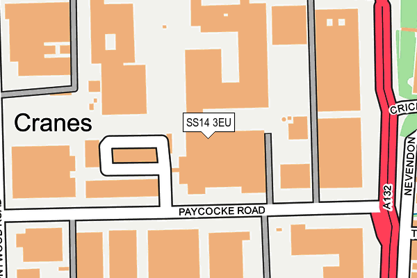
SS14 3EU lies on Heronsgate Trading Estate in Basildon. SS14 3EU is located in the Fryerns electoral ward, within the local authority district of Basildon and the English Parliamentary constituency of Basildon and Billericay. The Sub Integrated Care Board (ICB) Location is NHS Mid and South Essex ICB - 99E and the police force is Essex. This postcode has been in use since February 1990.


GetTheData
Source: OS OpenMap – Local (Ordnance Survey)
Source: OS VectorMap District (Ordnance Survey)
Licence: Open Government Licence (requires attribution)
| Easting | 572957 |
| Northing | 190826 |
| Latitude | 51.589741 |
| Longitude | 0.495364 |
GetTheData
Source: Open Postcode Geo
Licence: Open Government Licence
| Street | Heronsgate Trading Estate |
| Town/City | Basildon |
| Country | England |
| Postcode District | SS14 |
➜ See where SS14 is on a map ➜ Where is Basildon? | |
GetTheData
Source: Land Registry Price Paid Data
Licence: Open Government Licence
Elevation or altitude of SS14 3EU as distance above sea level:
| Metres | Feet | |
|---|---|---|
| Elevation | 20m | 66ft |
Elevation is measured from the approximate centre of the postcode, to the nearest point on an OS contour line from OS Terrain 50, which has contour spacing of ten vertical metres.
➜ How high above sea level am I? Find the elevation of your current position using your device's GPS.
GetTheData
Source: Open Postcode Elevation
Licence: Open Government Licence
| Ward | Fryerns |
| Constituency | Basildon And Billericay |
GetTheData
Source: ONS Postcode Database
Licence: Open Government Licence
| Bakers Court (Paycocke Road) | Basildon | 173m |
| Bakers Court (Paycocke Road) | Basildon | 181m |
| Sainsbury Store (East Mayne) | Basildon | 258m |
| Honywood Road (Paycocke Road) | Basildon | 263m |
| Honywood Road (Paycocke Road) | Basildon | 278m |
| Wickford Station | 3.3km |
| Pitsea Station | 3.4km |
| Basildon Station | 3.6km |
GetTheData
Source: NaPTAN
Licence: Open Government Licence
| Median download speed | 53.2Mbps |
| Average download speed | 42.1Mbps |
| Maximum download speed | 80.00Mbps |
| Median upload speed | 6.8Mbps |
| Average upload speed | 7.4Mbps |
| Maximum upload speed | 20.00Mbps |
GetTheData
Source: Ofcom
Licence: Ofcom Terms of Use (requires attribution)
Estimated total energy consumption in SS14 3EU by fuel type, 2015.
| Consumption (kWh) | 123,535 |
|---|---|
| Meter count | 14 |
| Mean (kWh/meter) | 8,824 |
| Median (kWh/meter) | 3,686 |
GetTheData
Source: Postcode level gas estimates: 2015 (experimental)
Source: Postcode level electricity estimates: 2015 (experimental)
Licence: Open Government Licence
GetTheData
Source: ONS Postcode Database
Licence: Open Government Licence


➜ Get more ratings from the Food Standards Agency
GetTheData
Source: Food Standards Agency
Licence: FSA terms & conditions
| Last Collection | |||
|---|---|---|---|
| Location | Mon-Fri | Sat | Distance |
| Chichester Close | 17:30 | 12:15 | 1,373m |
| Burnt Mills Road | 17:30 | 12:15 | 1,904m |
| Mill Green | 17:45 | 12:15 | 1,957m |
GetTheData
Source: Dracos
Licence: Creative Commons Attribution-ShareAlike
The below table lists the International Territorial Level (ITL) codes (formerly Nomenclature of Territorial Units for Statistics (NUTS) codes) and Local Administrative Units (LAU) codes for SS14 3EU:
| ITL 1 Code | Name |
|---|---|
| TLH | East |
| ITL 2 Code | Name |
| TLH3 | Essex |
| ITL 3 Code | Name |
| TLH37 | Essex Thames Gateway |
| LAU 1 Code | Name |
| E07000066 | Basildon |
GetTheData
Source: ONS Postcode Directory
Licence: Open Government Licence
The below table lists the Census Output Area (OA), Lower Layer Super Output Area (LSOA), and Middle Layer Super Output Area (MSOA) for SS14 3EU:
| Code | Name | |
|---|---|---|
| OA | E00108017 | |
| LSOA | E01021269 | Basildon 012C |
| MSOA | E02004435 | Basildon 012 |
GetTheData
Source: ONS Postcode Directory
Licence: Open Government Licence
| SS14 3EX | Olympic Business Centre | 128m |
| SS14 3NW | Paycocke Road | 163m |
| SS14 3EH | Bakers Court | 228m |
| SS13 1AW | Nevendon Road | 303m |
| SS13 1BT | Headingley Close | 330m |
| SS13 1BD | The Parks | 347m |
| SS13 1AL | The Parks | 356m |
| SS14 3EQ | Wickham Business Park | 363m |
| SS14 3JB | Cranes Close | 375m |
| SS14 3DF | Cranes Farm Road | 375m |
GetTheData
Source: Open Postcode Geo; Land Registry Price Paid Data
Licence: Open Government Licence