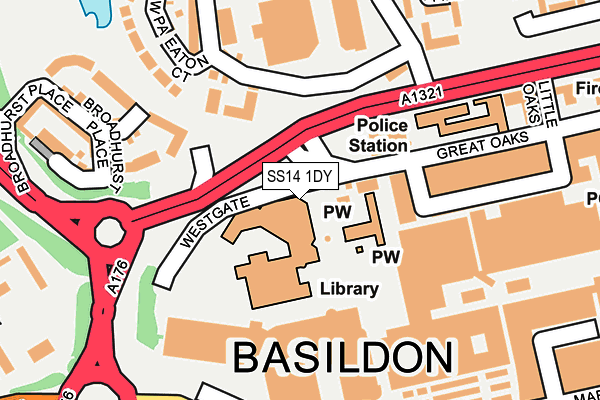
SS14 1DY is located in the St Martin's electoral ward, within the local authority district of Basildon and the English Parliamentary constituency of Basildon and Billericay. The Sub Integrated Care Board (ICB) Location is NHS Mid and South Essex ICB - 99E and the police force is Essex. This postcode has been in use since January 1980.


GetTheData
Source: OS OpenMap – Local (Ordnance Survey)
Source: OS VectorMap District (Ordnance Survey)
Licence: Open Government Licence (requires attribution)
| Easting | 570225 |
| Northing | 188649 |
| Latitude | 51.571014 |
| Longitude | 0.454882 |
GetTheData
Source: Open Postcode Geo
Licence: Open Government Licence
| Country | England |
| Postcode District | SS14 |
➜ See where SS14 is on a map ➜ Where is Basildon? | |
GetTheData
Source: Land Registry Price Paid Data
Licence: Open Government Licence
Elevation or altitude of SS14 1DY as distance above sea level:
| Metres | Feet | |
|---|---|---|
| Elevation | 30m | 98ft |
Elevation is measured from the approximate centre of the postcode, to the nearest point on an OS contour line from OS Terrain 50, which has contour spacing of ten vertical metres.
➜ How high above sea level am I? Find the elevation of your current position using your device's GPS.
GetTheData
Source: Open Postcode Elevation
Licence: Open Government Licence
| Ward | St Martin's |
| Constituency | Basildon And Billericay |
GetTheData
Source: ONS Postcode Database
Licence: Open Government Licence
| Roundacre (Upper Mayne) | Basildon | 295m |
| Roundacre (Upper Mayne) | Basildon | 315m |
| Hempstalls (Laindon Link) | Basildon | 346m |
| Ashdon Way | Basildon | 397m |
| Railway Station (Ashdon Way) | Basildon Town Centre | 429m |
| Basildon Station | 0.3km |
| Laindon Station | 2.2km |
| Pitsea Station | 3.8km |
GetTheData
Source: NaPTAN
Licence: Open Government Licence
GetTheData
Source: ONS Postcode Database
Licence: Open Government Licence
➜ Get more ratings from the Food Standards Agency
GetTheData
Source: Food Standards Agency
Licence: FSA terms & conditions
| Last Collection | |||
|---|---|---|---|
| Location | Mon-Fri | Sat | Distance |
| Basildon Post Office | 19:00 | 13:00 | 356m |
| The Gore | 17:45 | 11:45 | 520m |
| Cherrydown | 17:30 | 11:30 | 580m |
GetTheData
Source: Dracos
Licence: Creative Commons Attribution-ShareAlike
The below table lists the International Territorial Level (ITL) codes (formerly Nomenclature of Territorial Units for Statistics (NUTS) codes) and Local Administrative Units (LAU) codes for SS14 1DY:
| ITL 1 Code | Name |
|---|---|
| TLH | East |
| ITL 2 Code | Name |
| TLH3 | Essex |
| ITL 3 Code | Name |
| TLH37 | Essex Thames Gateway |
| LAU 1 Code | Name |
| E07000066 | Basildon |
GetTheData
Source: ONS Postcode Directory
Licence: Open Government Licence
The below table lists the Census Output Area (OA), Lower Layer Super Output Area (LSOA), and Middle Layer Super Output Area (MSOA) for SS14 1DY:
| Code | Name | |
|---|---|---|
| OA | E00108303 | |
| LSOA | E01021318 | Basildon 015C |
| MSOA | E02004438 | Basildon 015 |
GetTheData
Source: ONS Postcode Directory
Licence: Open Government Licence
| SS14 2FR | Blake Avenue | 145m |
| SS14 2FS | Blake Avenue | 177m |
| SS14 2FX | Eaton Court | 183m |
| SS14 2FA | Broadhurst Place | 196m |
| SS14 2BS | The Gore | 215m |
| SS14 2FT | Ambrose Chase | 254m |
| SS14 2AT | Pomfret Mead | 261m |
| SS14 2AU | Roodegate | 265m |
| SS14 2FQ | Broadhurst Place | 266m |
| SS14 1DD | Market Pavement | 269m |
GetTheData
Source: Open Postcode Geo; Land Registry Price Paid Data
Licence: Open Government Licence