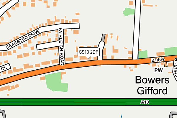
SS13 2DF is located in the Pitsea South East electoral ward, within the local authority district of Basildon and the English Parliamentary constituency of South Basildon and East Thurrock. The Sub Integrated Care Board (ICB) Location is NHS Mid and South Essex ICB - 99E and the police force is Essex. This postcode has been in use since April 2017.


GetTheData
Source: OS OpenMap – Local (Ordnance Survey)
Source: OS VectorMap District (Ordnance Survey)
Licence: Open Government Licence (requires attribution)
| Easting | 574613 |
| Northing | 188262 |
| Latitude | 51.566200 |
| Longitude | 0.517970 |
GetTheData
Source: Open Postcode Geo
Licence: Open Government Licence
| Country | England |
| Postcode District | SS13 |
➜ See where SS13 is on a map ➜ Where is Bowers Gifford? | |
GetTheData
Source: Land Registry Price Paid Data
Licence: Open Government Licence
| Ward | Pitsea South East |
| Constituency | South Basildon And East Thurrock |
GetTheData
Source: ONS Postcode Database
Licence: Open Government Licence
| The Bull (London Road) | Pitsea | 30m |
| The Bull (London Road) | Pitsea | 47m |
| Elham Drive (Halstow Way) | Pitsea | 309m |
| Elham Drive (Halstow Way) | Pitsea | 330m |
| Church Road (London Road) | Bowers Gifford | 377m |
| Pitsea Station | 1km |
| Benfleet Station | 3.9km |
| Basildon Station | 4.2km |
GetTheData
Source: NaPTAN
Licence: Open Government Licence
| Percentage of properties with Next Generation Access | 100.0% |
| Percentage of properties with Superfast Broadband | 100.0% |
| Percentage of properties with Ultrafast Broadband | 0.0% |
| Percentage of properties with Full Fibre Broadband | 0.0% |
Superfast Broadband is between 30Mbps and 300Mbps
Ultrafast Broadband is > 300Mbps
| Median download speed | 35.0Mbps |
| Average download speed | 29.8Mbps |
| Maximum download speed | 39.06Mbps |
| Median upload speed | 6.4Mbps |
| Average upload speed | 4.7Mbps |
| Maximum upload speed | 7.95Mbps |
| Percentage of properties unable to receive 2Mbps | 0.0% |
| Percentage of properties unable to receive 5Mbps | 0.0% |
| Percentage of properties unable to receive 10Mbps | 0.0% |
| Percentage of properties unable to receive 30Mbps | 0.0% |
GetTheData
Source: Ofcom
Licence: Ofcom Terms of Use (requires attribution)
GetTheData
Source: ONS Postcode Database
Licence: Open Government Licence


➜ Get more ratings from the Food Standards Agency
GetTheData
Source: Food Standards Agency
Licence: FSA terms & conditions
| Last Collection | |||
|---|---|---|---|
| Location | Mon-Fri | Sat | Distance |
| Rectory Road Post Office | 17:30 | 12:15 | 945m |
| Pitsea Post Office | 18:30 | 12:00 | 1,080m |
| Burnt Mills Road | 17:30 | 12:15 | 1,187m |
GetTheData
Source: Dracos
Licence: Creative Commons Attribution-ShareAlike
The below table lists the International Territorial Level (ITL) codes (formerly Nomenclature of Territorial Units for Statistics (NUTS) codes) and Local Administrative Units (LAU) codes for SS13 2DF:
| ITL 1 Code | Name |
|---|---|
| TLH | East |
| ITL 2 Code | Name |
| TLH3 | Essex |
| ITL 3 Code | Name |
| TLH37 | Essex Thames Gateway |
| LAU 1 Code | Name |
| E07000066 | Basildon |
GetTheData
Source: ONS Postcode Directory
Licence: Open Government Licence
The below table lists the Census Output Area (OA), Lower Layer Super Output Area (LSOA), and Middle Layer Super Output Area (MSOA) for SS13 2DF:
| Code | Name | |
|---|---|---|
| OA | E00108275 | |
| LSOA | E01021313 | Basildon 018A |
| MSOA | E02004441 | Basildon 018 |
GetTheData
Source: ONS Postcode Directory
Licence: Open Government Licence
| SS13 2DD | London Road | 40m |
| SS13 2BZ | London Road | 100m |
| SS13 2DY | Fairleigh Road | 127m |
| SS13 2DZ | Fairleigh Avenue | 134m |
| SS13 2DW | Bradbourne Way | 152m |
| SS13 2DB | London Road | 167m |
| SS13 2DA | London Road | 212m |
| SS13 2NZ | Tunstall Close | 242m |
| SS13 2NJ | Bearsted Drive | 248m |
| SS13 2DL | London Road | 248m |
GetTheData
Source: Open Postcode Geo; Land Registry Price Paid Data
Licence: Open Government Licence