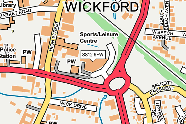
SS12 9FW is located in the Wickford Castledon electoral ward, within the local authority district of Basildon and the English Parliamentary constituency of Rayleigh and Wickford. The Sub Integrated Care Board (ICB) Location is NHS Mid and South Essex ICB - 99E and the police force is Essex. This postcode has been in use since February 2014.


GetTheData
Source: OS OpenMap – Local (Ordnance Survey)
Source: OS VectorMap District (Ordnance Survey)
Licence: Open Government Licence (requires attribution)
| Easting | 574736 |
| Northing | 193325 |
| Latitude | 51.611641 |
| Longitude | 0.522261 |
GetTheData
Source: Open Postcode Geo
Licence: Open Government Licence
| Country | England |
| Postcode District | SS12 |
➜ See where SS12 is on a map ➜ Where is Wickford? | |
GetTheData
Source: Land Registry Price Paid Data
Licence: Open Government Licence
Elevation or altitude of SS12 9FW as distance above sea level:
| Metres | Feet | |
|---|---|---|
| Elevation | 10m | 33ft |
Elevation is measured from the approximate centre of the postcode, to the nearest point on an OS contour line from OS Terrain 50, which has contour spacing of ten vertical metres.
➜ How high above sea level am I? Find the elevation of your current position using your device's GPS.
GetTheData
Source: Open Postcode Elevation
Licence: Open Government Licence
| Ward | Wickford Castledon |
| Constituency | Rayleigh And Wickford |
GetTheData
Source: ONS Postcode Database
Licence: Open Government Licence
| Halls Corner (Nevendon Road) | Wickford | 178m |
| Halls Corner (Nevendon Road) | Wickford | 188m |
| Halls Corner (London Road) | Wickford | 201m |
| Halls Corner (London Road) | Wickford | 243m |
| Tiptree Grove (Radwinter Avenue) | Wickford | 309m |
| Wickford Station | 0.4km |
| Battlesbridge Station | 3.3km |
| Basildon Station | 6.6km |
GetTheData
Source: NaPTAN
Licence: Open Government Licence
GetTheData
Source: ONS Postcode Database
Licence: Open Government Licence

➜ Get more ratings from the Food Standards Agency
GetTheData
Source: Food Standards Agency
Licence: FSA terms & conditions
| Last Collection | |||
|---|---|---|---|
| Location | Mon-Fri | Sat | Distance |
| Halls Corner | 17:30 | 11:30 | 187m |
| Station Approach | 17:30 | 12:00 | 408m |
| St Peters | 17:30 | 11:30 | 737m |
GetTheData
Source: Dracos
Licence: Creative Commons Attribution-ShareAlike
| Risk of SS12 9FW flooding from rivers and sea | Low |
| ➜ SS12 9FW flood map | |
GetTheData
Source: Open Flood Risk by Postcode
Licence: Open Government Licence
The below table lists the International Territorial Level (ITL) codes (formerly Nomenclature of Territorial Units for Statistics (NUTS) codes) and Local Administrative Units (LAU) codes for SS12 9FW:
| ITL 1 Code | Name |
|---|---|
| TLH | East |
| ITL 2 Code | Name |
| TLH3 | Essex |
| ITL 3 Code | Name |
| TLH37 | Essex Thames Gateway |
| LAU 1 Code | Name |
| E07000066 | Basildon |
GetTheData
Source: ONS Postcode Directory
Licence: Open Government Licence
The below table lists the Census Output Area (OA), Lower Layer Super Output Area (LSOA), and Middle Layer Super Output Area (MSOA) for SS12 9FW:
| Code | Name | |
|---|---|---|
| OA | E00108352 | |
| LSOA | E01021331 | Basildon 008A |
| MSOA | E02004431 | Basildon 008 |
GetTheData
Source: ONS Postcode Directory
Licence: Open Government Licence
| SS12 9AT | High Street | 131m |
| SS12 9AQ | High Street | 159m |
| SS12 9AS | Wick Drive | 165m |
| SS12 9FT | Golden Jubilee Way | 192m |
| SS12 0AL | Woodlands Road | 199m |
| SS11 8GB | Little Oak Mews | 202m |
| SS11 8BD | Stilemans | 210m |
| SS11 8AD | West Beech Mews | 230m |
| SS12 0QQ | Nevendon Road | 237m |
| SS12 9AP | North Crescent | 240m |
GetTheData
Source: Open Postcode Geo; Land Registry Price Paid Data
Licence: Open Government Licence