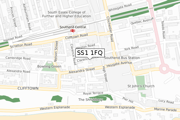
SS1 1FQ is located in the Milton electoral ward, within the unitary authority of Southend-on-Sea and the English Parliamentary constituency of Rochford and Southend East. The Sub Integrated Care Board (ICB) Location is NHS Mid and South Essex ICB - 99G and the police force is Essex. This postcode has been in use since September 2019.


GetTheData
Source: OS Open Zoomstack (Ordnance Survey)
Licence: Open Government Licence (requires attribution)
Attribution: Contains OS data © Crown copyright and database right 2025
Source: Open Postcode Geo
Licence: Open Government Licence (requires attribution)
Attribution: Contains OS data © Crown copyright and database right 2025; Contains Royal Mail data © Royal Mail copyright and database right 2025; Source: Office for National Statistics licensed under the Open Government Licence v.3.0
| Easting | 588244 |
| Northing | 185353 |
| Latitude | 51.535692 |
| Longitude | 0.712857 |
GetTheData
Source: Open Postcode Geo
Licence: Open Government Licence
| Country | England |
| Postcode District | SS1 |
➜ See where SS1 is on a map ➜ Where is Southend-on-Sea? | |
GetTheData
Source: Land Registry Price Paid Data
Licence: Open Government Licence
| Ward | Milton |
| Constituency | Rochford And Southend East |
GetTheData
Source: ONS Postcode Database
Licence: Open Government Licence
| Alexandra Road | Southend-on-sea | 127m |
| Southend Central Railway Station (Clifftown Road) | Southend-on-sea | 141m |
| Travel Centre (Chichester Road) | Southend-on-sea | 148m |
| Travel Centre (Chichester Road) | Southend-on-sea | 150m |
| Travel Centre (Chichester Road) | Southend-on-sea | 152m |
| Southend Central Station | 0.2km |
| Southend Victoria Station | 0.7km |
| Southend East Station | 1.4km |
GetTheData
Source: NaPTAN
Licence: Open Government Licence
GetTheData
Source: ONS Postcode Database
Licence: Open Government Licence


➜ Get more ratings from the Food Standards Agency
GetTheData
Source: Food Standards Agency
Licence: FSA terms & conditions
| Last Collection | |||
|---|---|---|---|
| Location | Mon-Fri | Sat | Distance |
| York Road | 17:30 | 11:30 | 80m |
| York Road | 17:30 | 11:30 | 84m |
| Central Station | 18:30 | 11:30 | 153m |
GetTheData
Source: Dracos
Licence: Creative Commons Attribution-ShareAlike
The below table lists the International Territorial Level (ITL) codes (formerly Nomenclature of Territorial Units for Statistics (NUTS) codes) and Local Administrative Units (LAU) codes for SS1 1FQ:
| ITL 1 Code | Name |
|---|---|
| TLH | East |
| ITL 2 Code | Name |
| TLH3 | Essex |
| ITL 3 Code | Name |
| TLH31 | Southend-on-Sea |
| LAU 1 Code | Name |
| E06000033 | Southend-on-Sea |
GetTheData
Source: ONS Postcode Directory
Licence: Open Government Licence
The below table lists the Census Output Area (OA), Lower Layer Super Output Area (LSOA), and Middle Layer Super Output Area (MSOA) for SS1 1FQ:
| Code | Name | |
|---|---|---|
| OA | E00080144 | |
| LSOA | E01015852 | Southend-on-Sea 015B |
| MSOA | E02003293 | Southend-on-Sea 015 |
GetTheData
Source: ONS Postcode Directory
Licence: Open Government Licence
| SS1 1BH | Clarence Street | 4m |
| SS1 1BD | Clarence Street | 34m |
| SS1 1BU | Alexandra Street | 39m |
| SS1 1BX | Alexandra Street | 65m |
| SS1 1HZ | High Street | 73m |
| SS1 1DA | Market Place | 83m |
| SS1 1JG | High Street | 89m |
| SS1 1AS | Weston Road | 93m |
| SS1 1AN | Clarence Road | 100m |
| SS1 1BW | Alexandra Street | 110m |
GetTheData
Source: Open Postcode Geo; Land Registry Price Paid Data
Licence: Open Government Licence