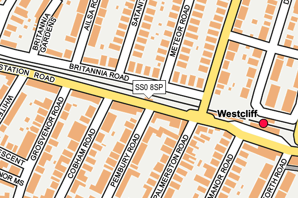
SS0 8SP is located in the Chalkwell electoral ward, within the unitary authority of Southend-on-Sea and the English Parliamentary constituency of Southend West. The Sub Integrated Care Board (ICB) Location is NHS Mid and South Essex ICB - 99G and the police force is Essex. This postcode has been in use since December 1997.


GetTheData
Source: OS OpenMap – Local (Ordnance Survey)
Source: OS VectorMap District (Ordnance Survey)
Licence: Open Government Licence (requires attribution)
| Easting | 586521 |
| Northing | 185543 |
| Latitude | 51.537966 |
| Longitude | 0.688114 |
GetTheData
Source: Open Postcode Geo
Licence: Open Government Licence
| Country | England |
| Postcode District | SS0 |
➜ See where SS0 is on a map ➜ Where is Southend-on-Sea? | |
GetTheData
Source: Land Registry Price Paid Data
Licence: Open Government Licence
Elevation or altitude of SS0 8SP as distance above sea level:
| Metres | Feet | |
|---|---|---|
| Elevation | 20m | 66ft |
Elevation is measured from the approximate centre of the postcode, to the nearest point on an OS contour line from OS Terrain 50, which has contour spacing of ten vertical metres.
➜ How high above sea level am I? Find the elevation of your current position using your device's GPS.
GetTheData
Source: Open Postcode Elevation
Licence: Open Government Licence
| Ward | Chalkwell |
| Constituency | Southend West |
GetTheData
Source: ONS Postcode Database
Licence: Open Government Licence
| Palmerston Road (Station Road) | Westcliff-on-sea | 47m |
| Cobham Road (Station Road) | Westcliff-on-sea | 114m |
| Cobham Road (Station Road) | Westcliff-on-sea | 144m |
| Westcliff-on-sea Railway Station (Station Road) | Westcliff-on-sea | 244m |
| Westcliff-on-sea Railway Station (Station Road) | Westcliff-on-sea | 258m |
| Westcliff-on-Sea Station | 0.2km |
| Chalkwell Station | 1.2km |
| Southend Central Station | 1.6km |
GetTheData
Source: NaPTAN
Licence: Open Government Licence
GetTheData
Source: ONS Postcode Database
Licence: Open Government Licence


➜ Get more ratings from the Food Standards Agency
GetTheData
Source: Food Standards Agency
Licence: FSA terms & conditions
| Last Collection | |||
|---|---|---|---|
| Location | Mon-Fri | Sat | Distance |
| Britannia Road | 17:30 | 11:30 | 40m |
| Pembury Road | 17:30 | 11:30 | 250m |
| Whitefriars Crescent | 17:30 | 11:30 | 269m |
GetTheData
Source: Dracos
Licence: Creative Commons Attribution-ShareAlike
The below table lists the International Territorial Level (ITL) codes (formerly Nomenclature of Territorial Units for Statistics (NUTS) codes) and Local Administrative Units (LAU) codes for SS0 8SP:
| ITL 1 Code | Name |
|---|---|
| TLH | East |
| ITL 2 Code | Name |
| TLH3 | Essex |
| ITL 3 Code | Name |
| TLH31 | Southend-on-Sea |
| LAU 1 Code | Name |
| E06000033 | Southend-on-Sea |
GetTheData
Source: ONS Postcode Directory
Licence: Open Government Licence
The below table lists the Census Output Area (OA), Lower Layer Super Output Area (LSOA), and Middle Layer Super Output Area (MSOA) for SS0 8SP:
| Code | Name | |
|---|---|---|
| OA | E00080015 | |
| LSOA | E01015828 | Southend-on-Sea 012B |
| MSOA | E02003290 | Southend-on-Sea 012 |
GetTheData
Source: ONS Postcode Directory
Licence: Open Government Licence
| SS0 8DZ | Station Road | 55m |
| SS0 7SD | Station Road | 72m |
| SS0 8BS | Britannia Road | 75m |
| SS0 7FJ | Palmerston Road | 86m |
| SS0 8DU | Pembury Road | 113m |
| SS0 8DS | Pembury Road | 115m |
| SS0 8HF | Station Road | 130m |
| SS0 7TA | Palmerston Road | 142m |
| SS0 8BP | Britannia Road | 152m |
| SS0 7TB | Palmerston Road | 156m |
GetTheData
Source: Open Postcode Geo; Land Registry Price Paid Data
Licence: Open Government Licence