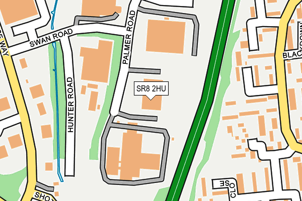
SR8 2HU is located in the Shotton and South Hetton electoral ward, within the unitary authority of County Durham and the English Parliamentary constituency of Easington. The Sub Integrated Care Board (ICB) Location is NHS North East and North Cumbria ICB - 84H and the police force is Durham. This postcode has been in use since August 1993.


GetTheData
Source: OS OpenMap – Local (Ordnance Survey)
Source: OS VectorMap District (Ordnance Survey)
Licence: Open Government Licence (requires attribution)
| Easting | 441222 |
| Northing | 540275 |
| Latitude | 54.755746 |
| Longitude | -1.361025 |
GetTheData
Source: Open Postcode Geo
Licence: Open Government Licence
| Country | England |
| Postcode District | SR8 |
➜ See where SR8 is on a map ➜ Where is Peterlee? | |
GetTheData
Source: Land Registry Price Paid Data
Licence: Open Government Licence
Elevation or altitude of SR8 2HU as distance above sea level:
| Metres | Feet | |
|---|---|---|
| Elevation | 130m | 427ft |
Elevation is measured from the approximate centre of the postcode, to the nearest point on an OS contour line from OS Terrain 50, which has contour spacing of ten vertical metres.
➜ How high above sea level am I? Find the elevation of your current position using your device's GPS.
GetTheData
Source: Open Postcode Elevation
Licence: Open Government Licence
| Ward | Shotton And South Hetton |
| Constituency | Easington |
GetTheData
Source: ONS Postcode Database
Licence: Open Government Licence
| Pennine Drive - Polden Close (Pennine Drive) | Peterlee | 265m |
| Pennine Drive - Polden Close (Pennine Drive) | Peterlee | 266m |
| Swan Road (Whitehouse Way) | Peterlee | 290m |
| Swan Road (Whitehouse Way) | Peterlee | 323m |
| Pennine Drive - Brecon Close (Pennine Drive) | Peterlee | 385m |
GetTheData
Source: NaPTAN
Licence: Open Government Licence
GetTheData
Source: ONS Postcode Database
Licence: Open Government Licence


➜ Get more ratings from the Food Standards Agency
GetTheData
Source: Food Standards Agency
Licence: FSA terms & conditions
| Last Collection | |||
|---|---|---|---|
| Location | Mon-Fri | Sat | Distance |
| O'neill Drive | 17:15 | 13:15 | 1,536m |
| Eden Hill Road | 16:45 | 12:00 | 1,707m |
| Peterlee Post Office | 18:30 | 12:15 | 2,007m |
GetTheData
Source: Dracos
Licence: Creative Commons Attribution-ShareAlike
The below table lists the International Territorial Level (ITL) codes (formerly Nomenclature of Territorial Units for Statistics (NUTS) codes) and Local Administrative Units (LAU) codes for SR8 2HU:
| ITL 1 Code | Name |
|---|---|
| TLC | North East (England) |
| ITL 2 Code | Name |
| TLC1 | Tees Valley and Durham |
| ITL 3 Code | Name |
| TLC14 | Durham |
| LAU 1 Code | Name |
| E06000047 | County Durham |
GetTheData
Source: ONS Postcode Directory
Licence: Open Government Licence
The below table lists the Census Output Area (OA), Lower Layer Super Output Area (LSOA), and Middle Layer Super Output Area (MSOA) for SR8 2HU:
| Code | Name | |
|---|---|---|
| OA | E00105350 | |
| LSOA | E01020761 | County Durham 034B |
| MSOA | E02004326 | County Durham 034 |
GetTheData
Source: ONS Postcode Directory
Licence: Open Government Licence
| SR8 2LQ | Polden Close | 197m |
| SR8 2LF | Snowdon Place | 214m |
| SR8 2LH | Polden Close | 217m |
| SR8 2LD | Pentland Close | 229m |
| SR8 2LG | Snowdon Place | 247m |
| SR8 2LJ | Hambledon Place | 248m |
| SR8 2LB | Pentland Close | 253m |
| SR8 2LE | Pentland Close | 278m |
| SR8 2RJ | Winchester Drive | 284m |
| SR8 2LA | Pentland Close | 302m |
GetTheData
Source: Open Postcode Geo; Land Registry Price Paid Data
Licence: Open Government Licence