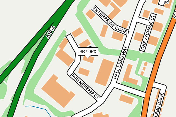
SR7 0PX lies on Seaham Grange Food Park in Seaham Grange Industrial Estate, Seaham. SR7 0PX is located in the Seaham electoral ward, within the unitary authority of County Durham and the English Parliamentary constituency of Easington. The Sub Integrated Care Board (ICB) Location is NHS North East and North Cumbria ICB - 84H and the police force is Durham. This postcode has been in use since June 1999.


GetTheData
Source: OS OpenMap – Local (Ordnance Survey)
Source: OS VectorMap District (Ordnance Survey)
Licence: Open Government Licence (requires attribution)
| Easting | 440421 |
| Northing | 550697 |
| Latitude | 54.849460 |
| Longitude | -1.372021 |
GetTheData
Source: Open Postcode Geo
Licence: Open Government Licence
| Street | Seaham Grange Food Park |
| Locality | Seaham Grange Industrial Estate |
| Town/City | Seaham |
| Country | England |
| Postcode District | SR7 |
➜ See where SR7 is on a map ➜ Where is Seaham? | |
GetTheData
Source: Land Registry Price Paid Data
Licence: Open Government Licence
Elevation or altitude of SR7 0PX as distance above sea level:
| Metres | Feet | |
|---|---|---|
| Elevation | 70m | 230ft |
Elevation is measured from the approximate centre of the postcode, to the nearest point on an OS contour line from OS Terrain 50, which has contour spacing of ten vertical metres.
➜ How high above sea level am I? Find the elevation of your current position using your device's GPS.
GetTheData
Source: Open Postcode Elevation
Licence: Open Government Licence
| Ward | Seaham |
| Constituency | Easington |
GetTheData
Source: ONS Postcode Database
Licence: Open Government Licence
| Industrial Estate (Un-named Road) | Seaham Grange | 169m |
| Industrial Estate (Un-named Road) | Seaham Grange | 177m |
| Glebe Est - Four Houses (B1285 Stockton Road) | Seaham Grange | 240m |
| Glebe Est - Four Houses (B1285 Stockton Road) | Seaham Grange | 242m |
| Seaham Grange Farm (B1285 Stockton Road) | Seaham Grange | 443m |
| Seaham Station | 2km |
GetTheData
Source: NaPTAN
Licence: Open Government Licence
Estimated total energy consumption in SR7 0PX by fuel type, 2015.
| Consumption (kWh) | 117,820 |
|---|---|
| Meter count | 8 |
| Mean (kWh/meter) | 14,727 |
| Median (kWh/meter) | 9,815 |
GetTheData
Source: Postcode level gas estimates: 2015 (experimental)
Source: Postcode level electricity estimates: 2015 (experimental)
Licence: Open Government Licence
GetTheData
Source: ONS Postcode Database
Licence: Open Government Licence


➜ Get more ratings from the Food Standards Agency
GetTheData
Source: Food Standards Agency
Licence: FSA terms & conditions
| Last Collection | |||
|---|---|---|---|
| Location | Mon-Fri | Sat | Distance |
| Ryhope Post Office | 17:15 | 11:45 | 2,317m |
| Station Road North | 16:45 | 11:30 | 2,610m |
| Tunstall Vale | 17:00 | 11:30 | 3,804m |
GetTheData
Source: Dracos
Licence: Creative Commons Attribution-ShareAlike
The below table lists the International Territorial Level (ITL) codes (formerly Nomenclature of Territorial Units for Statistics (NUTS) codes) and Local Administrative Units (LAU) codes for SR7 0PX:
| ITL 1 Code | Name |
|---|---|
| TLC | North East (England) |
| ITL 2 Code | Name |
| TLC1 | Tees Valley and Durham |
| ITL 3 Code | Name |
| TLC14 | Durham |
| LAU 1 Code | Name |
| E06000047 | County Durham |
GetTheData
Source: ONS Postcode Directory
Licence: Open Government Licence
The below table lists the Census Output Area (OA), Lower Layer Super Output Area (LSOA), and Middle Layer Super Output Area (MSOA) for SR7 0PX:
| Code | Name | |
|---|---|---|
| OA | E00105472 | |
| LSOA | E01020786 | County Durham 016D |
| MSOA | E02004320 | County Durham 016 |
GetTheData
Source: ONS Postcode Directory
Licence: Open Government Licence
| SR7 0PY | Hall Dene Way | 146m |
| SR7 0NT | Stockton Road | 202m |
| SR7 0PS | Enterprise Court | 209m |
| SR7 0DB | Field House Farm | 270m |
| SR7 0NS | Stockton Road | 281m |
| SR7 0PD | Glebe Drive | 292m |
| SR7 0PE | South Grange Park | 318m |
| SR7 0PF | Stockton Road | 341m |
| SR7 0JQ | Burdon Crescent | 462m |
| SR7 0JE | Stockton Road | 485m |
GetTheData
Source: Open Postcode Geo; Land Registry Price Paid Data
Licence: Open Government Licence