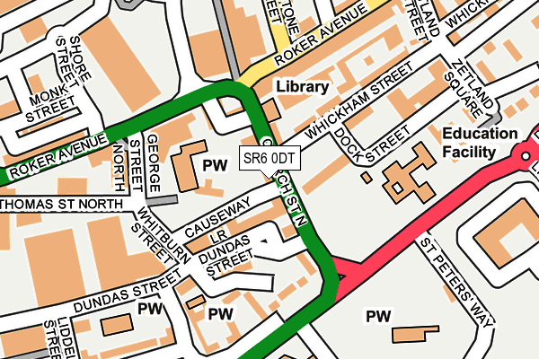
SR6 0DT lies on Church Street North in Sunderland. SR6 0DT is located in the St Peter's electoral ward, within the metropolitan district of Sunderland and the English Parliamentary constituency of Sunderland Central. The Sub Integrated Care Board (ICB) Location is NHS North East and North Cumbria ICB - 00P and the police force is Northumbria. This postcode has been in use since January 1980.


GetTheData
Source: OS OpenMap – Local (Ordnance Survey)
Source: OS VectorMap District (Ordnance Survey)
Licence: Open Government Licence (requires attribution)
| Easting | 440014 |
| Northing | 557955 |
| Latitude | 54.914704 |
| Longitude | -1.377341 |
GetTheData
Source: Open Postcode Geo
Licence: Open Government Licence
| Street | Church Street North |
| Town/City | Sunderland |
| Country | England |
| Postcode District | SR6 |
➜ See where SR6 is on a map ➜ Where is Sunderland? | |
GetTheData
Source: Land Registry Price Paid Data
Licence: Open Government Licence
Elevation or altitude of SR6 0DT as distance above sea level:
| Metres | Feet | |
|---|---|---|
| Elevation | 20m | 66ft |
Elevation is measured from the approximate centre of the postcode, to the nearest point on an OS contour line from OS Terrain 50, which has contour spacing of ten vertical metres.
➜ How high above sea level am I? Find the elevation of your current position using your device's GPS.
GetTheData
Source: Open Postcode Elevation
Licence: Open Government Licence
| Ward | St Peter's |
| Constituency | Sunderland Central |
GetTheData
Source: ONS Postcode Database
Licence: Open Government Licence
| Church Street North | St Peter's | 80m |
| Lower Dundas Street | St Peter's | 84m |
| Roker Avenue-george Street North (Roker Avenue) | Monkwearmouth | 174m |
| Fulwell Road-retail Park (Fullwell Road) | Monkwearmouth | 191m |
| Fulwell Road-retail Park (Fulwell Road) | Monkwearmouth | 211m |
| Stadium Of Light (Tyne And Wear Metro Station) (Millennium Way) | Sunderland Stadium Of Light | 530m |
| St Peter's (Tyne And Wear Metro Station) (Sheepfolds North) | St Peter's | 550m |
| Sunderland (Tyne And Wear Metro Station) (Station Street) | Sunderland | 970m |
| Park Lane (Tyne And Wear Metro Station) (Park Lane) | Park Lane | 1,451m |
| University (Tyne And Wear Metro Station) (A183 Chester Road) | University Of Sunderland | 1,629m |
| St Peters Station | 0.6km |
| Sunderland Station | 1.1km |
| Seaburn Station | 1.8km |
GetTheData
Source: NaPTAN
Licence: Open Government Licence
| Percentage of properties with Next Generation Access | 100.0% |
| Percentage of properties with Superfast Broadband | 100.0% |
| Percentage of properties with Ultrafast Broadband | 0.0% |
| Percentage of properties with Full Fibre Broadband | 0.0% |
Superfast Broadband is between 30Mbps and 300Mbps
Ultrafast Broadband is > 300Mbps
| Percentage of properties unable to receive 2Mbps | 0.0% |
| Percentage of properties unable to receive 5Mbps | 0.0% |
| Percentage of properties unable to receive 10Mbps | 0.0% |
| Percentage of properties unable to receive 30Mbps | 0.0% |
GetTheData
Source: Ofcom
Licence: Ofcom Terms of Use (requires attribution)
Estimated total energy consumption in SR6 0DT by fuel type, 2015.
| Consumption (kWh) | 166,584 |
|---|---|
| Meter count | 10 |
| Mean (kWh/meter) | 16,658 |
| Median (kWh/meter) | 10,274 |
| Consumption (kWh) | 30,843 |
|---|---|
| Meter count | 6 |
| Mean (kWh/meter) | 5,140 |
| Median (kWh/meter) | 4,182 |
GetTheData
Source: Postcode level gas estimates: 2015 (experimental)
Source: Postcode level electricity estimates: 2015 (experimental)
Licence: Open Government Licence
GetTheData
Source: ONS Postcode Database
Licence: Open Government Licence


➜ Get more ratings from the Food Standards Agency
GetTheData
Source: Food Standards Agency
Licence: FSA terms & conditions
| Last Collection | |||
|---|---|---|---|
| Location | Mon-Fri | Sat | Distance |
| North Bridge Street | 16:45 | 11:30 | 362m |
| Roker Baths Road | 17:30 | 12:15 | 576m |
| Sheepfolds | 17:00 | 11:30 | 623m |
GetTheData
Source: Dracos
Licence: Creative Commons Attribution-ShareAlike
The below table lists the International Territorial Level (ITL) codes (formerly Nomenclature of Territorial Units for Statistics (NUTS) codes) and Local Administrative Units (LAU) codes for SR6 0DT:
| ITL 1 Code | Name |
|---|---|
| TLC | North East (England) |
| ITL 2 Code | Name |
| TLC2 | Northumberland, and Tyne and Wear |
| ITL 3 Code | Name |
| TLC23 | Sunderland |
| LAU 1 Code | Name |
| E08000024 | Sunderland |
GetTheData
Source: ONS Postcode Directory
Licence: Open Government Licence
The below table lists the Census Output Area (OA), Lower Layer Super Output Area (LSOA), and Middle Layer Super Output Area (MSOA) for SR6 0DT:
| Code | Name | |
|---|---|---|
| OA | E00044635 | |
| LSOA | E01008791 | Sunderland 006F |
| MSOA | E02001796 | Sunderland 006 |
GetTheData
Source: ONS Postcode Directory
Licence: Open Government Licence
| SR6 0BD | Lower Dundas Street | 50m |
| SR6 0DR | Church Street North | 52m |
| SR6 0DZ | Dock Street | 79m |
| SR6 0BS | Roker Avenue | 115m |
| SR6 0AG | St Peters View | 141m |
| SR6 0EB | Whickham Street | 146m |
| SR6 0HQ | Roker Avenue | 166m |
| SR6 0BN | Roker Avenue | 186m |
| SR6 0HX | Roker Avenue | 199m |
| SR6 0EQ | Zetland Street | 238m |
GetTheData
Source: Open Postcode Geo; Land Registry Price Paid Data
Licence: Open Government Licence