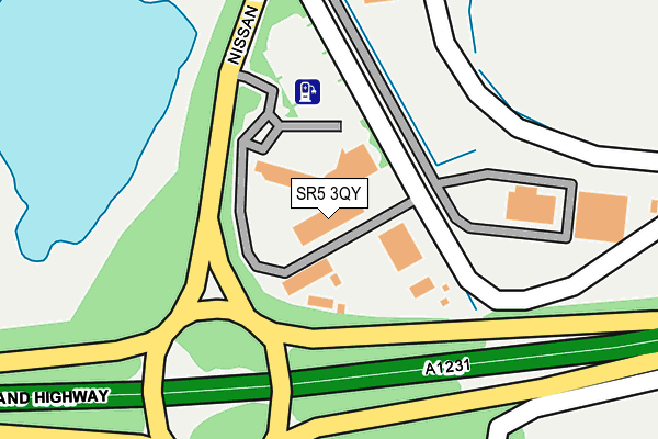
SR5 3QY is located in the Washington North electoral ward, within the metropolitan district of Sunderland and the English Parliamentary constituency of Washington and Sunderland West. The Sub Integrated Care Board (ICB) Location is NHS North East and North Cumbria ICB - 00P and the police force is Northumbria. This postcode has been in use since December 1996.


GetTheData
Source: OS OpenMap – Local (Ordnance Survey)
Source: OS VectorMap District (Ordnance Survey)
Licence: Open Government Licence (requires attribution)
| Easting | 432957 |
| Northing | 557052 |
| Latitude | 54.907103 |
| Longitude | -1.487522 |
GetTheData
Source: Open Postcode Geo
Licence: Open Government Licence
| Country | England |
| Postcode District | SR5 |
➜ See where SR5 is on a map | |
GetTheData
Source: Land Registry Price Paid Data
Licence: Open Government Licence
Elevation or altitude of SR5 3QY as distance above sea level:
| Metres | Feet | |
|---|---|---|
| Elevation | 30m | 98ft |
Elevation is measured from the approximate centre of the postcode, to the nearest point on an OS contour line from OS Terrain 50, which has contour spacing of ten vertical metres.
➜ How high above sea level am I? Find the elevation of your current position using your device's GPS.
GetTheData
Source: Open Postcode Elevation
Licence: Open Government Licence
| Ward | Washington North |
| Constituency | Washington And Sunderland West |
GetTheData
Source: ONS Postcode Database
Licence: Open Government Licence
| Washington District 15 Exit (Sunderland Highway) | Barmston | 99m |
| Nissan Way-a1231 (Nissan Way) | Barmston | 105m |
| Nissan Way-training Centre (Nissan Way) | Barmston | 142m |
| Nissan Way-mere (Nissan Way) | Barmston | 213m |
| Washington District 15 Exit (Sunderlands Highway) | Barmston | 299m |
| East Boldon Station | 6.1km |
| Heworth Station | 6.6km |
GetTheData
Source: NaPTAN
Licence: Open Government Licence
GetTheData
Source: ONS Postcode Database
Licence: Open Government Licence


➜ Get more ratings from the Food Standards Agency
GetTheData
Source: Food Standards Agency
Licence: FSA terms & conditions
| Last Collection | |||
|---|---|---|---|
| Location | Mon-Fri | Sat | Distance |
| Pattinson North Industrial Est | 18:30 | 525m | |
| Lee Close | 16:15 | 10:30 | 567m |
| Pattinson Road | 16:30 | 10:30 | 1,203m |
GetTheData
Source: Dracos
Licence: Creative Commons Attribution-ShareAlike
The below table lists the International Territorial Level (ITL) codes (formerly Nomenclature of Territorial Units for Statistics (NUTS) codes) and Local Administrative Units (LAU) codes for SR5 3QY:
| ITL 1 Code | Name |
|---|---|
| TLC | North East (England) |
| ITL 2 Code | Name |
| TLC2 | Northumberland, and Tyne and Wear |
| ITL 3 Code | Name |
| TLC23 | Sunderland |
| LAU 1 Code | Name |
| E08000024 | Sunderland |
GetTheData
Source: ONS Postcode Directory
Licence: Open Government Licence
The below table lists the Census Output Area (OA), Lower Layer Super Output Area (LSOA), and Middle Layer Super Output Area (MSOA) for SR5 3QY:
| Code | Name | |
|---|---|---|
| OA | E00044950 | |
| LSOA | E01008855 | Sunderland 007A |
| MSOA | E02001797 | Sunderland 007 |
GetTheData
Source: ONS Postcode Directory
Licence: Open Government Licence
| NE38 8QJ | Faraday Close | 630m |
| NE38 8QF | Lee Close | 703m |
| NE38 8LF | 841m | |
| NE38 8HF | Horsley Road | 858m |
| NE38 8HE | Horsley Road | 871m |
| NE37 2PA | Peel Retail Park | 872m |
| NE38 8HQ | Horsley Road | 928m |
| NE38 8HG | Horsley Road | 938m |
| NE37 3HY | Severn Houses | 963m |
| NE38 8JB | Stockley Road | 969m |
GetTheData
Source: Open Postcode Geo; Land Registry Price Paid Data
Licence: Open Government Licence