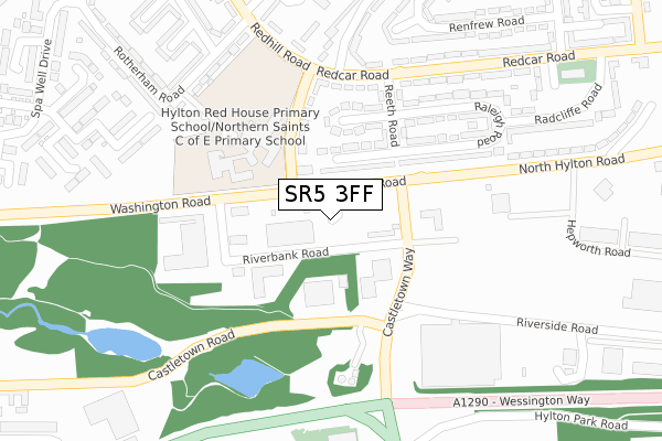
SR5 3FF is located in the Castle electoral ward, within the metropolitan district of Sunderland and the English Parliamentary constituency of Washington and Sunderland West. The Sub Integrated Care Board (ICB) Location is NHS North East and North Cumbria ICB - 00P and the police force is Northumbria. This postcode has been in use since October 2017.


GetTheData
Source: OS Open Zoomstack (Ordnance Survey)
Licence: Open Government Licence (requires attribution)
Attribution: Contains OS data © Crown copyright and database right 2025
Source: Open Postcode Geo
Licence: Open Government Licence (requires attribution)
Attribution: Contains OS data © Crown copyright and database right 2025; Contains Royal Mail data © Royal Mail copyright and database right 2025; Source: Office for National Statistics licensed under the Open Government Licence v.3.0
| Easting | 436742 |
| Northing | 558707 |
| Latitude | 54.921720 |
| Longitude | -1.428296 |
GetTheData
Source: Open Postcode Geo
Licence: Open Government Licence
| Country | England |
| Postcode District | SR5 |
➜ See where SR5 is on a map ➜ Where is Sunderland? | |
GetTheData
Source: Land Registry Price Paid Data
Licence: Open Government Licence
| Ward | Castle |
| Constituency | Washington And Sunderland West |
GetTheData
Source: ONS Postcode Database
Licence: Open Government Licence
| North Hylton Road-castletown Way (North Hylton Road) | Hylton Red House | 91m |
| Radlett Road | Hylton Red House | 151m |
| Washington Road-wear View (Washington Road) | Hylton Red House | 163m |
| Castletown Way-riverbank Road (Castletown Lane) | Hylton Red House | 179m |
| Radlett Road | Hylton Red House | 203m |
| Pallion (Tyne And Wear Metro Station) (European Way) | Pallion | 1,221m |
| East Boldon Station | 2.8km |
| Seaburn Station | 2.8km |
| St Peters Station | 3.1km |
GetTheData
Source: NaPTAN
Licence: Open Government Licence
GetTheData
Source: ONS Postcode Database
Licence: Open Government Licence


➜ Get more ratings from the Food Standards Agency
GetTheData
Source: Food Standards Agency
Licence: FSA terms & conditions
| Last Collection | |||
|---|---|---|---|
| Location | Mon-Fri | Sat | Distance |
| Freda Street | 17:30 | 12:30 | 1,235m |
| Pallion Way | 19:00 | 12:15 | 1,354m |
| Fordham Road | 17:00 | 12:30 | 1,563m |
GetTheData
Source: Dracos
Licence: Creative Commons Attribution-ShareAlike
The below table lists the International Territorial Level (ITL) codes (formerly Nomenclature of Territorial Units for Statistics (NUTS) codes) and Local Administrative Units (LAU) codes for SR5 3FF:
| ITL 1 Code | Name |
|---|---|
| TLC | North East (England) |
| ITL 2 Code | Name |
| TLC2 | Northumberland, and Tyne and Wear |
| ITL 3 Code | Name |
| TLC23 | Sunderland |
| LAU 1 Code | Name |
| E08000024 | Sunderland |
GetTheData
Source: ONS Postcode Directory
Licence: Open Government Licence
The below table lists the Census Output Area (OA), Lower Layer Super Output Area (LSOA), and Middle Layer Super Output Area (MSOA) for SR5 3FF:
| Code | Name | |
|---|---|---|
| OA | E00044145 | |
| LSOA | E01008693 | Sunderland 008A |
| MSOA | E02001798 | Sunderland 008 |
GetTheData
Source: ONS Postcode Directory
Licence: Open Government Licence
| SR5 5RA | Raleigh Square | 137m |
| SR5 5QZ | Radlett Road | 171m |
| SR5 5RF | Reeth Square | 191m |
| SR5 5RE | Reeth Road | 245m |
| SR5 5QL | Rotherham Road | 279m |
| SR5 5RB | Raleigh Road | 288m |
| SR5 5QG | Rochdale Way | 303m |
| SR5 5QB | Runnymede Road | 322m |
| SR5 5RD | Raleigh Road | 324m |
| SR5 5TX | Plumtree Avenue | 326m |
GetTheData
Source: Open Postcode Geo; Land Registry Price Paid Data
Licence: Open Government Licence