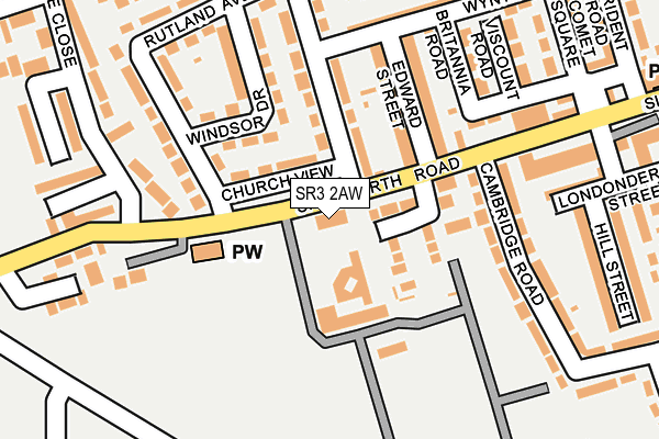
SR3 2AW is located in the Silksworth electoral ward, within the metropolitan district of Sunderland and the English Parliamentary constituency of Houghton and Sunderland South. The Sub Integrated Care Board (ICB) Location is NHS North East and North Cumbria ICB - 00P and the police force is Northumbria. This postcode has been in use since December 2022.


GetTheData
Source: OS OpenMap – Local (Ordnance Survey)
Source: OS VectorMap District (Ordnance Survey)
Licence: Open Government Licence (requires attribution)
| Easting | 438114 |
| Northing | 553129 |
| Latitude | 54.871495 |
| Longitude | -1.407627 |
GetTheData
Source: Open Postcode Geo
Licence: Open Government Licence
| Country | England |
| Postcode District | SR3 |
➜ See where SR3 is on a map ➜ Where is Sunderland? | |
GetTheData
Source: Land Registry Price Paid Data
Licence: Open Government Licence
Elevation or altitude of SR3 2AW as distance above sea level:
| Metres | Feet | |
|---|---|---|
| Elevation | 90m | 295ft |
Elevation is measured from the approximate centre of the postcode, to the nearest point on an OS contour line from OS Terrain 50, which has contour spacing of ten vertical metres.
➜ How high above sea level am I? Find the elevation of your current position using your device's GPS.
GetTheData
Source: Open Postcode Elevation
Licence: Open Government Licence
| Ward | Silksworth |
| Constituency | Houghton And Sunderland South |
GetTheData
Source: ONS Postcode Database
Licence: Open Government Licence
| Vicarage Farm Estate (Silksworth Road) | Silksworth | 29m |
| Vicarage Farm Estate (Church View) | Silksworth | 85m |
| Vicarage Farm Estate (Silksworth Road) | Silksworth | 103m |
| Silksworth Terrace-cambridge Road (Silksworth Road) | Silksworth | 118m |
| Silksworth Terrace-comet Square (Silksworth Terrace) | Silksworth | 208m |
| Sunderland Station | 4.1km |
| St Peters Station | 4.7km |
| Seaham Station | 5.3km |
GetTheData
Source: NaPTAN
Licence: Open Government Licence
GetTheData
Source: ONS Postcode Database
Licence: Open Government Licence


➜ Get more ratings from the Food Standards Agency
GetTheData
Source: Food Standards Agency
Licence: FSA terms & conditions
| Last Collection | |||
|---|---|---|---|
| Location | Mon-Fri | Sat | Distance |
| Gilley Law Post Office | 16:45 | 10:30 | 994m |
| New Silksworth Post Office | 17:00 | 11:30 | 1,296m |
| Allendale Road | 16:45 | 10:30 | 1,307m |
GetTheData
Source: Dracos
Licence: Creative Commons Attribution-ShareAlike
The below table lists the International Territorial Level (ITL) codes (formerly Nomenclature of Territorial Units for Statistics (NUTS) codes) and Local Administrative Units (LAU) codes for SR3 2AW:
| ITL 1 Code | Name |
|---|---|
| TLC | North East (England) |
| ITL 2 Code | Name |
| TLC2 | Northumberland, and Tyne and Wear |
| ITL 3 Code | Name |
| TLC23 | Sunderland |
| LAU 1 Code | Name |
| E08000024 | Sunderland |
GetTheData
Source: ONS Postcode Directory
Licence: Open Government Licence
The below table lists the Census Output Area (OA), Lower Layer Super Output Area (LSOA), and Middle Layer Super Output Area (MSOA) for SR3 2AW:
| Code | Name | |
|---|---|---|
| OA | E00044717 | |
| LSOA | E01033077 | Sunderland 027F |
| MSOA | E02001817 | Sunderland 027 |
GetTheData
Source: ONS Postcode Directory
Licence: Open Government Licence
| SR3 1JJ | Church View | 72m |
| SR3 2ET | St Matthews View | 86m |
| SR3 1JH | Rutland Avenue | 135m |
| SR3 1JQ | Windsor Drive | 138m |
| SR3 1EW | Edward Street | 145m |
| SR3 1JA | Trident Road | 180m |
| SR3 1JL | Vicarage Road | 191m |
| SR3 1HZ | Britannia Road | 192m |
| SR3 1ER | Wynyard Street | 202m |
| SR3 2DQ | Cambridge Road | 208m |
GetTheData
Source: Open Postcode Geo; Land Registry Price Paid Data
Licence: Open Government Licence