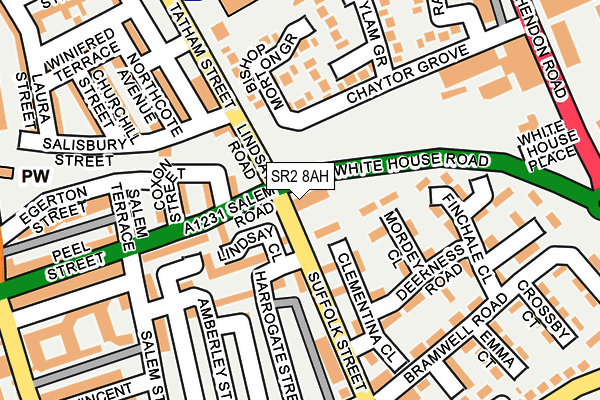
SR2 8AH is located in the Hendon electoral ward, within the metropolitan district of Sunderland and the English Parliamentary constituency of Sunderland Central. The Sub Integrated Care Board (ICB) Location is NHS North East and North Cumbria ICB - 00P and the police force is Northumbria. This postcode has been in use since May 2012.


GetTheData
Source: OS OpenMap – Local (Ordnance Survey)
Source: OS VectorMap District (Ordnance Survey)
Licence: Open Government Licence (requires attribution)
| Easting | 440310 |
| Northing | 556489 |
| Latitude | 54.901515 |
| Longitude | -1.372942 |
GetTheData
Source: Open Postcode Geo
Licence: Open Government Licence
| Country | England |
| Postcode District | SR2 |
➜ See where SR2 is on a map ➜ Where is Sunderland? | |
GetTheData
Source: Land Registry Price Paid Data
Licence: Open Government Licence
Elevation or altitude of SR2 8AH as distance above sea level:
| Metres | Feet | |
|---|---|---|
| Elevation | 30m | 98ft |
Elevation is measured from the approximate centre of the postcode, to the nearest point on an OS contour line from OS Terrain 50, which has contour spacing of ten vertical metres.
➜ How high above sea level am I? Find the elevation of your current position using your device's GPS.
GetTheData
Source: Open Postcode Elevation
Licence: Open Government Licence
| Ward | Hendon |
| Constituency | Sunderland Central |
GetTheData
Source: ONS Postcode Database
Licence: Open Government Licence
| Linsey Road | Hendon | 43m |
| Suffolk Street-deerness Road (Suffolk Street) | Hendon | 142m |
| Tatham Street | Hendon | 154m |
| Tatham Street | Hendon | 173m |
| Suffolk Street-st Ignatius Close (Suffolk Street) | Hendon | 287m |
| Park Lane (Tyne And Wear Metro Station) (Park Lane) | Park Lane | 734m |
| Sunderland (Tyne And Wear Metro Station) (Station Street) | Sunderland | 835m |
| University (Tyne And Wear Metro Station) (A183 Chester Road) | University Of Sunderland | 1,247m |
| St Peter's (Tyne And Wear Metro Station) (Sheepfolds North) | St Peter's | 1,306m |
| Sunderland Station | 0.7km |
| St Peters Station | 1.3km |
| Seaburn Station | 3.2km |
GetTheData
Source: NaPTAN
Licence: Open Government Licence
GetTheData
Source: ONS Postcode Database
Licence: Open Government Licence


➜ Get more ratings from the Food Standards Agency
GetTheData
Source: Food Standards Agency
Licence: FSA terms & conditions
| Last Collection | |||
|---|---|---|---|
| Location | Mon-Fri | Sat | Distance |
| Hendon Road | 17:30 | 10:30 | 352m |
| Crown House Post Office | 17:00 | 12:15 | 470m |
| Toward Road | 17:30 | 12:00 | 497m |
GetTheData
Source: Dracos
Licence: Creative Commons Attribution-ShareAlike
The below table lists the International Territorial Level (ITL) codes (formerly Nomenclature of Territorial Units for Statistics (NUTS) codes) and Local Administrative Units (LAU) codes for SR2 8AH:
| ITL 1 Code | Name |
|---|---|
| TLC | North East (England) |
| ITL 2 Code | Name |
| TLC2 | Northumberland, and Tyne and Wear |
| ITL 3 Code | Name |
| TLC23 | Sunderland |
| LAU 1 Code | Name |
| E08000024 | Sunderland |
GetTheData
Source: ONS Postcode Directory
Licence: Open Government Licence
The below table lists the Census Output Area (OA), Lower Layer Super Output Area (LSOA), and Middle Layer Super Output Area (MSOA) for SR2 8AH:
| Code | Name | |
|---|---|---|
| OA | E00044374 | |
| LSOA | E01008736 | Sunderland 016C |
| MSOA | E02001806 | Sunderland 016 |
GetTheData
Source: ONS Postcode Directory
Licence: Open Government Licence
| SR2 8AB | Suffolk Street | 60m |
| SR2 8AG | Clementina Close | 72m |
| SR2 8AQ | Mordey Close | 73m |
| SR2 8DA | Lindsay Close | 86m |
| SR2 8DY | Bishopton Street | 111m |
| SR1 2RX | Bishop Morton Grove | 121m |
| SR2 8AP | Deerness Road | 141m |
| SR2 8AR | Finchale Close | 142m |
| SR2 8DB | Osman Close | 158m |
| SR2 8DX | Coxon Street | 162m |
GetTheData
Source: Open Postcode Geo; Land Registry Price Paid Data
Licence: Open Government Licence