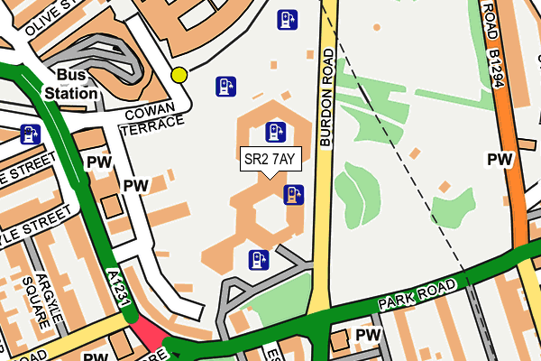
SR2 7AY is located in the St Michael's electoral ward, within the metropolitan district of Sunderland and the English Parliamentary constituency of Sunderland Central. The Sub Integrated Care Board (ICB) Location is NHS North East and North Cumbria ICB - 00P and the police force is Northumbria. This postcode has been in use since June 2008.


GetTheData
Source: OS OpenMap – Local (Ordnance Survey)
Source: OS VectorMap District (Ordnance Survey)
Licence: Open Government Licence (requires attribution)
| Easting | 439702 |
| Northing | 556540 |
| Latitude | 54.902022 |
| Longitude | -1.382416 |
GetTheData
Source: Open Postcode Geo
Licence: Open Government Licence
| Country | England |
| Postcode District | SR2 |
➜ See where SR2 is on a map ➜ Where is Sunderland? | |
GetTheData
Source: Land Registry Price Paid Data
Licence: Open Government Licence
Elevation or altitude of SR2 7AY as distance above sea level:
| Metres | Feet | |
|---|---|---|
| Elevation | 40m | 131ft |
Elevation is measured from the approximate centre of the postcode, to the nearest point on an OS contour line from OS Terrain 50, which has contour spacing of ten vertical metres.
➜ How high above sea level am I? Find the elevation of your current position using your device's GPS.
GetTheData
Source: Open Postcode Elevation
Licence: Open Government Licence
| Ward | St Michael's |
| Constituency | Sunderland Central |
GetTheData
Source: ONS Postcode Database
Licence: Open Government Licence
| Cowan Terrace (Cowans Terrace) | Sunderland | 96m |
| Burdon Road-civic Centre (Burdon Road) | Sunderland | 105m |
| Park Lane Interchange (Park Lane) | Sunderland | 153m |
| Sunderland Interchange (Park Lane) | Sunderland | 164m |
| Sunderland Interchange (Park Lane) | Sunderland | 165m |
| Park Lane (Tyne And Wear Metro Station) (Park Lane) | Park Lane | 126m |
| Sunderland (Tyne And Wear Metro Station) (Station Street) | Sunderland | 503m |
| University (Tyne And Wear Metro Station) (A183 Chester Road) | University Of Sunderland | 637m |
| St Peter's (Tyne And Wear Metro Station) (Sheepfolds North) | St Peter's | 1,053m |
| Millfield (Tyne And Wear Metro Station) (Hylton Road) | Millfield | 1,315m |
| Sunderland Station | 0.4km |
| St Peters Station | 1.1km |
| Seaburn Station | 3.1km |
GetTheData
Source: NaPTAN
Licence: Open Government Licence
GetTheData
Source: ONS Postcode Database
Licence: Open Government Licence


➜ Get more ratings from the Food Standards Agency
GetTheData
Source: Food Standards Agency
Licence: FSA terms & conditions
| Last Collection | |||
|---|---|---|---|
| Location | Mon-Fri | Sat | Distance |
| Stockton Road | 18:45 | 12:15 | 227m |
| Park Lane | 18:30 | 10:30 | 269m |
| Holmeside | 18:30 | 10:30 | 279m |
GetTheData
Source: Dracos
Licence: Creative Commons Attribution-ShareAlike
The below table lists the International Territorial Level (ITL) codes (formerly Nomenclature of Territorial Units for Statistics (NUTS) codes) and Local Administrative Units (LAU) codes for SR2 7AY:
| ITL 1 Code | Name |
|---|---|
| TLC | North East (England) |
| ITL 2 Code | Name |
| TLC2 | Northumberland, and Tyne and Wear |
| ITL 3 Code | Name |
| TLC23 | Sunderland |
| LAU 1 Code | Name |
| E08000024 | Sunderland |
GetTheData
Source: ONS Postcode Directory
Licence: Open Government Licence
The below table lists the Census Output Area (OA), Lower Layer Super Output Area (LSOA), and Middle Layer Super Output Area (MSOA) for SR2 7AY:
| Code | Name | |
|---|---|---|
| OA | E00170238 | |
| LSOA | E01008831 | Sunderland 013D |
| MSOA | E02001803 | Sunderland 013 |
GetTheData
Source: ONS Postcode Directory
Licence: Open Government Licence
| SR2 7AQ | Stockton Road | 205m |
| SR2 7BW | St Georges Way | 208m |
| SR1 3PE | Olive Street | 250m |
| SR2 7BN | Grange Crescent | 250m |
| SR2 7DF | Grange Terrace | 255m |
| SR2 8HR | Park Road | 259m |
| SR2 7DX | Douro Terrace | 266m |
| SR2 7DH | Argyle Street | 281m |
| SR2 7AL | Alice Street | 282m |
| SR1 3JE | Holmeside | 285m |
GetTheData
Source: Open Postcode Geo; Land Registry Price Paid Data
Licence: Open Government Licence