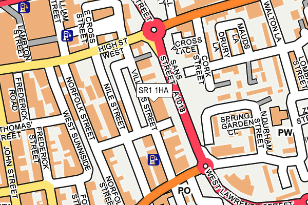
SR1 1HA lies on Villiers Street in Sunderland. SR1 1HA is located in the Hendon electoral ward, within the metropolitan district of Sunderland and the English Parliamentary constituency of Sunderland Central. The Sub Integrated Care Board (ICB) Location is NHS North East and North Cumbria ICB - 00P and the police force is Northumbria. This postcode has been in use since January 1980.


GetTheData
Source: OS OpenMap – Local (Ordnance Survey)
Source: OS VectorMap District (Ordnance Survey)
Licence: Open Government Licence (requires attribution)
| Easting | 440107 |
| Northing | 557118 |
| Latitude | 54.907183 |
| Longitude | -1.376020 |
GetTheData
Source: Open Postcode Geo
Licence: Open Government Licence
| Street | Villiers Street |
| Town/City | Sunderland |
| Country | England |
| Postcode District | SR1 |
➜ See where SR1 is on a map ➜ Where is Sunderland? | |
GetTheData
Source: Land Registry Price Paid Data
Licence: Open Government Licence
Elevation or altitude of SR1 1HA as distance above sea level:
| Metres | Feet | |
|---|---|---|
| Elevation | 30m | 98ft |
Elevation is measured from the approximate centre of the postcode, to the nearest point on an OS contour line from OS Terrain 50, which has contour spacing of ten vertical metres.
➜ How high above sea level am I? Find the elevation of your current position using your device's GPS.
GetTheData
Source: Open Postcode Elevation
Licence: Open Government Licence
| Ward | Hendon |
| Constituency | Sunderland Central |
GetTheData
Source: ONS Postcode Database
Licence: Open Government Licence
| High Street West-frederick Road (High Street West) | Sunderland | 144m |
| High Street East-sans Street (High Street East) | East End | 161m |
| Borough Road-villiers Street (Borough Road) | East End | 182m |
| High Street East-cork Street (High Street East) | East End | 186m |
| West Sunniside | Sunderland | 190m |
| Sunderland (Tyne And Wear Metro Station) (Station Street) | Sunderland | 429m |
| St Peter's (Tyne And Wear Metro Station) (Sheepfolds North) | St Peter's | 688m |
| Park Lane (Tyne And Wear Metro Station) (Park Lane) | Park Lane | 760m |
| University (Tyne And Wear Metro Station) (A183 Chester Road) | University Of Sunderland | 1,146m |
| Stadium Of Light (Tyne And Wear Metro Station) (Millennium Way) | Sunderland Stadium Of Light | 1,307m |
| Sunderland Station | 0.5km |
| St Peters Station | 0.7km |
| Seaburn Station | 2.6km |
GetTheData
Source: NaPTAN
Licence: Open Government Licence
GetTheData
Source: ONS Postcode Database
Licence: Open Government Licence


➜ Get more ratings from the Food Standards Agency
GetTheData
Source: Food Standards Agency
Licence: FSA terms & conditions
| Last Collection | |||
|---|---|---|---|
| Location | Mon-Fri | Sat | Distance |
| Emsworth Road | 17:00 | 11:15 | 95m |
| Crown House Post Office | 17:00 | 12:15 | 193m |
| St Thomas Street | 249m | ||
GetTheData
Source: Dracos
Licence: Creative Commons Attribution-ShareAlike
The below table lists the International Territorial Level (ITL) codes (formerly Nomenclature of Territorial Units for Statistics (NUTS) codes) and Local Administrative Units (LAU) codes for SR1 1HA:
| ITL 1 Code | Name |
|---|---|
| TLC | North East (England) |
| ITL 2 Code | Name |
| TLC2 | Northumberland, and Tyne and Wear |
| ITL 3 Code | Name |
| TLC23 | Sunderland |
| LAU 1 Code | Name |
| E08000024 | Sunderland |
GetTheData
Source: ONS Postcode Directory
Licence: Open Government Licence
The below table lists the Census Output Area (OA), Lower Layer Super Output Area (LSOA), and Middle Layer Super Output Area (MSOA) for SR1 1HA:
| Code | Name | |
|---|---|---|
| OA | E00170202 | |
| LSOA | E01008703 | Sunderland 013B |
| MSOA | E02001803 | Sunderland 013 |
GetTheData
Source: ONS Postcode Directory
Licence: Open Government Licence
| SR1 1UP | High Street West | 94m |
| SR1 1ER | Villiers Street | 96m |
| SR1 1UF | High Street West | 98m |
| SR1 1UW | High Street West | 120m |
| SR1 1UN | High Street West | 126m |
| SR1 1EJ | Villiers Street | 131m |
| SR1 2AN | Cork Street | 140m |
| SR1 1EA | Norfolk Street | 141m |
| SR1 1ES | Nile Street | 152m |
| SR1 1BH | West Sunniside | 165m |
GetTheData
Source: Open Postcode Geo; Land Registry Price Paid Data
Licence: Open Government Licence