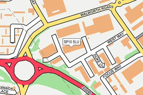
SP10 5LU is located in the Andover Downlands electoral ward, within the local authority district of Test Valley and the English Parliamentary constituency of North West Hampshire. The Sub Integrated Care Board (ICB) Location is NHS Hampshire and Isle of Wight ICB - D9Y0V and the police force is Hampshire. This postcode has been in use since January 1993.


GetTheData
Source: OS OpenMap – Local (Ordnance Survey)
Source: OS VectorMap District (Ordnance Survey)
Licence: Open Government Licence (requires attribution)
| Easting | 437777 |
| Northing | 146488 |
| Latitude | 51.216345 |
| Longitude | -1.460496 |
GetTheData
Source: Open Postcode Geo
Licence: Open Government Licence
| Country | England |
| Postcode District | SP10 |
➜ See where SP10 is on a map ➜ Where is Andover? | |
GetTheData
Source: Land Registry Price Paid Data
Licence: Open Government Licence
Elevation or altitude of SP10 5LU as distance above sea level:
| Metres | Feet | |
|---|---|---|
| Elevation | 70m | 230ft |
Elevation is measured from the approximate centre of the postcode, to the nearest point on an OS contour line from OS Terrain 50, which has contour spacing of ten vertical metres.
➜ How high above sea level am I? Find the elevation of your current position using your device's GPS.
GetTheData
Source: Open Postcode Elevation
Licence: Open Government Licence
| Ward | Andover Downlands |
| Constituency | North West Hampshire |
GetTheData
Source: ONS Postcode Database
Licence: Open Government Licence
| South Way (Walworth Road) | Picket Piece | 98m |
| The Swallow (Pilgrims Way) | Andover | 142m |
| The Swallow (Pilgrims Way) | Andover | 145m |
| The Swallow (River Way) | Andover | 178m |
| South Way (Walworth Road) | Picket Piece | 182m |
| Andover Station | 2.3km |
GetTheData
Source: NaPTAN
Licence: Open Government Licence
GetTheData
Source: ONS Postcode Database
Licence: Open Government Licence


➜ Get more ratings from the Food Standards Agency
GetTheData
Source: Food Standards Agency
Licence: FSA terms & conditions
| Last Collection | |||
|---|---|---|---|
| Location | Mon-Fri | Sat | Distance |
| Walworth Industrial Estate | 18:30 | 12:00 | 171m |
| London Road | 17:45 | 12:30 | 821m |
| Batchelors Barn Road | 17:45 | 12:30 | 860m |
GetTheData
Source: Dracos
Licence: Creative Commons Attribution-ShareAlike
The below table lists the International Territorial Level (ITL) codes (formerly Nomenclature of Territorial Units for Statistics (NUTS) codes) and Local Administrative Units (LAU) codes for SP10 5LU:
| ITL 1 Code | Name |
|---|---|
| TLJ | South East (England) |
| ITL 2 Code | Name |
| TLJ3 | Hampshire and Isle of Wight |
| ITL 3 Code | Name |
| TLJ36 | Central Hampshire |
| LAU 1 Code | Name |
| E07000093 | Test Valley |
GetTheData
Source: ONS Postcode Directory
Licence: Open Government Licence
The below table lists the Census Output Area (OA), Lower Layer Super Output Area (LSOA), and Middle Layer Super Output Area (MSOA) for SP10 5LU:
| Code | Name | |
|---|---|---|
| OA | E00117898 | |
| LSOA | E01023201 | Test Valley 003B |
| MSOA | E02004816 | Test Valley 003 |
GetTheData
Source: ONS Postcode Directory
Licence: Open Government Licence
| SP10 5HY | Pilgrims Way | 183m |
| SP10 5HU | Pilgrims Way | 274m |
| SP10 5HX | Pilgrims Way | 283m |
| SP10 5AZ | North Way | 289m |
| SP10 5HD | Wye Court | 306m |
| SP10 5HE | Tyne Court | 306m |
| SP10 5NY | Focus 303 Business Centre | 307m |
| SP10 1LB | Granada Place | 326m |
| SP10 5HF | Trent Court | 346m |
| SP10 5HG | Test Court | 361m |
GetTheData
Source: Open Postcode Geo; Land Registry Price Paid Data
Licence: Open Government Licence