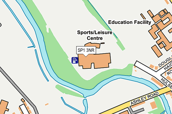
SP1 3NR is located in the Salisbury St Francis & Stratford electoral ward, within the unitary authority of Wiltshire and the English Parliamentary constituency of Salisbury. The Sub Integrated Care Board (ICB) Location is NHS Bath and North East Somerset, Swindon and Wiltshire ICB - 92 and the police force is Wiltshire. This postcode has been in use since September 1991.


GetTheData
Source: OS OpenMap – Local (Ordnance Survey)
Source: OS VectorMap District (Ordnance Survey)
Licence: Open Government Licence (requires attribution)
| Easting | 413860 |
| Northing | 131042 |
| Latitude | 51.078536 |
| Longitude | -1.803527 |
GetTheData
Source: Open Postcode Geo
Licence: Open Government Licence
| Country | England |
| Postcode District | SP1 |
➜ See where SP1 is on a map ➜ Where is Salisbury? | |
GetTheData
Source: Land Registry Price Paid Data
Licence: Open Government Licence
Elevation or altitude of SP1 3NR as distance above sea level:
| Metres | Feet | |
|---|---|---|
| Elevation | 50m | 164ft |
Elevation is measured from the approximate centre of the postcode, to the nearest point on an OS contour line from OS Terrain 50, which has contour spacing of ten vertical metres.
➜ How high above sea level am I? Find the elevation of your current position using your device's GPS.
GetTheData
Source: Open Postcode Elevation
Licence: Open Government Licence
| Ward | Salisbury St Francis & Stratford |
| Constituency | Salisbury |
GetTheData
Source: ONS Postcode Database
Licence: Open Government Licence
| South Wilts Grammar School (Stratford Road) | Salisbury | 358m |
| South Wilts Grammar School (Stratford Road) | Salisbury | 369m |
| Stratford Court | Salisbury | 384m |
| Victoria Park (Stratford Road) | Salisbury | 399m |
| Avon Lodge Vets (Stratford Road) | Salisbury | 416m |
| Salisbury Station | 0.9km |
GetTheData
Source: NaPTAN
Licence: Open Government Licence
GetTheData
Source: ONS Postcode Database
Licence: Open Government Licence


➜ Get more ratings from the Food Standards Agency
GetTheData
Source: Food Standards Agency
Licence: FSA terms & conditions
| Last Collection | |||
|---|---|---|---|
| Location | Mon-Fri | Sat | Distance |
| Butts Road | 17:30 | 12:00 | 361m |
| Waitrose (Post Office) | 18:30 | 12:00 | 376m |
| Victoria Road | 16:15 | 12:00 | 466m |
GetTheData
Source: Dracos
Licence: Creative Commons Attribution-ShareAlike
The below table lists the International Territorial Level (ITL) codes (formerly Nomenclature of Territorial Units for Statistics (NUTS) codes) and Local Administrative Units (LAU) codes for SP1 3NR:
| ITL 1 Code | Name |
|---|---|
| TLK | South West (England) |
| ITL 2 Code | Name |
| TLK1 | Gloucestershire, Wiltshire and Bath/Bristol area |
| ITL 3 Code | Name |
| TLK15 | Wiltshire |
| LAU 1 Code | Name |
| E06000054 | Wiltshire |
GetTheData
Source: ONS Postcode Directory
Licence: Open Government Licence
The below table lists the Census Output Area (OA), Lower Layer Super Output Area (LSOA), and Middle Layer Super Output Area (MSOA) for SP1 3NR:
| Code | Name | |
|---|---|---|
| OA | E00163319 | |
| LSOA | E01032019 | Wiltshire 053B |
| MSOA | E02006668 | Wiltshire 053 |
GetTheData
Source: ONS Postcode Directory
Licence: Open Government Licence
| SP1 3NA | Hulse Road | 240m |
| SP2 7DD | Ashley Road | 269m |
| SP1 3LZ | Hulse Road | 292m |
| SP2 7DG | Westminster Road | 300m |
| SP1 3NB | Douglas Haig Road | 316m |
| SP2 7BX | Avon Terrace | 326m |
| SP2 7DQ | Kingsland Road | 346m |
| SP2 7BT | Avon Terrace | 348m |
| SP1 3ET | Hulse Road | 348m |
| SP2 7DH | Richmond Road | 353m |
GetTheData
Source: Open Postcode Geo; Land Registry Price Paid Data
Licence: Open Government Licence