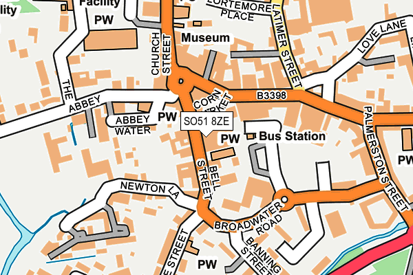
SO51 8ZE is located in the Romsey Abbey electoral ward, within the local authority district of Test Valley and the English Parliamentary constituency of Romsey and Southampton North. The Sub Integrated Care Board (ICB) Location is NHS Hampshire and Isle of Wight ICB - D9Y0V and the police force is Hampshire. This postcode has been in use since January 1986.


GetTheData
Source: OS OpenMap – Local (Ordnance Survey)
Source: OS VectorMap District (Ordnance Survey)
Licence: Open Government Licence (requires attribution)
| Easting | 435233 |
| Northing | 121114 |
| Latitude | 50.988355 |
| Longitude | -1.499401 |
GetTheData
Source: Open Postcode Geo
Licence: Open Government Licence
| Country | England |
| Postcode District | SO51 |
➜ See where SO51 is on a map ➜ Where is Romsey? | |
GetTheData
Source: Land Registry Price Paid Data
Licence: Open Government Licence
Elevation or altitude of SO51 8ZE as distance above sea level:
| Metres | Feet | |
|---|---|---|
| Elevation | 10m | 33ft |
Elevation is measured from the approximate centre of the postcode, to the nearest point on an OS contour line from OS Terrain 50, which has contour spacing of ten vertical metres.
➜ How high above sea level am I? Find the elevation of your current position using your device's GPS.
GetTheData
Source: Open Postcode Elevation
Licence: Open Government Licence
| Ward | Romsey Abbey |
| Constituency | Romsey And Southampton North |
GetTheData
Source: ONS Postcode Database
Licence: Open Government Licence
| Coach Drop Off And Pick Up Point (Nr Broadwater Road) | Romsey | 104m |
| Council Offices (Church Street) | Romsey | 188m |
| Council Offices (Church Street) | Romsey | 191m |
| Linden Road (The Hundred) | Romsey | 276m |
| Linden Road (The Hundred) | Romsey | 353m |
| Romsey Station | 0.6km |
GetTheData
Source: NaPTAN
Licence: Open Government Licence
GetTheData
Source: ONS Postcode Database
Licence: Open Government Licence


➜ Get more ratings from the Food Standards Agency
GetTheData
Source: Food Standards Agency
Licence: FSA terms & conditions
| Last Collection | |||
|---|---|---|---|
| Location | Mon-Fri | Sat | Distance |
| Romsey Post Office | 18:00 | 12:00 | 180m |
| Station Road | 17:30 | 11:45 | 272m |
| Rivermead Close | 17:30 | 12:00 | 343m |
GetTheData
Source: Dracos
Licence: Creative Commons Attribution-ShareAlike
The below table lists the International Territorial Level (ITL) codes (formerly Nomenclature of Territorial Units for Statistics (NUTS) codes) and Local Administrative Units (LAU) codes for SO51 8ZE:
| ITL 1 Code | Name |
|---|---|
| TLJ | South East (England) |
| ITL 2 Code | Name |
| TLJ3 | Hampshire and Isle of Wight |
| ITL 3 Code | Name |
| TLJ36 | Central Hampshire |
| LAU 1 Code | Name |
| E07000093 | Test Valley |
GetTheData
Source: ONS Postcode Directory
Licence: Open Government Licence
The below table lists the Census Output Area (OA), Lower Layer Super Output Area (LSOA), and Middle Layer Super Output Area (MSOA) for SO51 8ZE:
| Code | Name | |
|---|---|---|
| OA | E00117623 | |
| LSOA | E01023151 | Test Valley 011B |
| MSOA | E02004824 | Test Valley 011 |
GetTheData
Source: ONS Postcode Directory
Licence: Open Government Licence
| SO51 8GY | Bell Street | 35m |
| SO51 8GW | Bell Street | 35m |
| SO51 8GB | Cornmarket | 37m |
| SO51 8JR | Bell Court | 60m |
| SO51 8AL | Bell Street | 65m |
| SO51 8NA | Market Place | 92m |
| SO51 8EJ | Abbey Water | 103m |
| SO51 8NB | Market Place | 104m |
| SO51 8BW | The Hundred | 110m |
| SO51 8PJ | Broadwater Road | 111m |
GetTheData
Source: Open Postcode Geo; Land Registry Price Paid Data
Licence: Open Government Licence