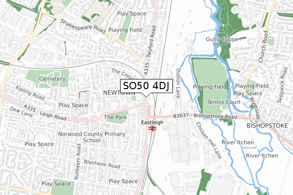
SO50 4DJ is located in the Eastleigh Central electoral ward, within the local authority district of Eastleigh and the English Parliamentary constituency of Eastleigh. The Sub Integrated Care Board (ICB) Location is NHS Hampshire and Isle of Wight ICB - D9Y0V and the police force is Hampshire. This postcode has been in use since January 2018.


GetTheData
Source: OS Open Zoomstack (Ordnance Survey)
Licence: Open Government Licence (requires attribution)
Attribution: Contains OS data © Crown copyright and database right 2025
Source: Open Postcode Geo
Licence: Open Government Licence (requires attribution)
Attribution: Contains OS data © Crown copyright and database right 2025; Contains Royal Mail data © Royal Mail copyright and database right 2025; Source: Office for National Statistics licensed under the Open Government Licence v.3.0
| Easting | 445697 |
| Northing | 119329 |
| Latitude | 50.971563 |
| Longitude | -1.350540 |
GetTheData
Source: Open Postcode Geo
Licence: Open Government Licence
| Country | England |
| Postcode District | SO50 |
➜ See where SO50 is on a map ➜ Where is Eastleigh? | |
GetTheData
Source: Land Registry Price Paid Data
Licence: Open Government Licence
| Ward | Eastleigh Central |
| Constituency | Eastleigh |
GetTheData
Source: ONS Postcode Database
Licence: Open Government Licence
| Coach Stop (Upper Market Street) | Eastleigh | 167m |
| Health Centre Taxistop (Newtown Road) | Eastleigh | 225m |
| Eastleigh Station (Station Hill) | Eastleigh | 261m |
| Newtown Road (Romsey Road) | Eastleigh | 288m |
| Dutton Lane (Bishopstoke Road) | Eastleigh | 321m |
| Eastleigh Station | 0.3km |
| Southampton Airport Parkway Station | 2.5km |
| Chandlers Ford Station | 2.8km |
GetTheData
Source: NaPTAN
Licence: Open Government Licence
GetTheData
Source: ONS Postcode Database
Licence: Open Government Licence


➜ Get more ratings from the Food Standards Agency
GetTheData
Source: Food Standards Agency
Licence: FSA terms & conditions
| Last Collection | |||
|---|---|---|---|
| Location | Mon-Fri | Sat | Distance |
| Newtown Road | 17:00 | 12:00 | 231m |
| Lower Leigh Road | 18:30 | 12:00 | 269m |
| Twyford Road | 17:00 | 12:00 | 363m |
GetTheData
Source: Dracos
Licence: Creative Commons Attribution-ShareAlike
The below table lists the International Territorial Level (ITL) codes (formerly Nomenclature of Territorial Units for Statistics (NUTS) codes) and Local Administrative Units (LAU) codes for SO50 4DJ:
| ITL 1 Code | Name |
|---|---|
| TLJ | South East (England) |
| ITL 2 Code | Name |
| TLJ3 | Hampshire and Isle of Wight |
| ITL 3 Code | Name |
| TLJ35 | South Hampshire |
| LAU 1 Code | Name |
| E07000086 | Eastleigh |
GetTheData
Source: ONS Postcode Directory
Licence: Open Government Licence
The below table lists the Census Output Area (OA), Lower Layer Super Output Area (LSOA), and Middle Layer Super Output Area (MSOA) for SO50 4DJ:
| Code | Name | |
|---|---|---|
| OA | E00115236 | |
| LSOA | E01022671 | Eastleigh 007D |
| MSOA | E02004718 | Eastleigh 007 |
GetTheData
Source: ONS Postcode Directory
Licence: Open Government Licence
| SO50 9BU | George Street | 157m |
| SO50 9FJ | Station Hill | 169m |
| SO50 9BS | The Crescent | 170m |
| SO50 9XB | Southampton Road | 182m |
| SO50 4DF | Ashton Gardens | 196m |
| SO50 9DB | Newtown Road | 207m |
| SO50 9BR | The Crescent | 209m |
| SO50 9BT | George Street | 215m |
| SO50 9FH | Leigh Road | 243m |
| SO50 9DA | Newtown Road | 247m |
GetTheData
Source: Open Postcode Geo; Land Registry Price Paid Data
Licence: Open Government Licence