SO41 9PW open data databoard
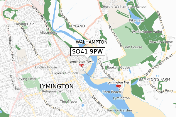
SO41 9PW is located in the Lymington electoral ward, within the local authority district of New Forest and the English Parliamentary constituency of New Forest West. The Sub Integrated Care Board (ICB) Location is NHS Hampshire and Isle of Wight ICB - D9Y0V and the police force is Hampshire. This postcode has been in use since August 2017.
SO41 9PW maps


Licence: Open Government Licence (requires attribution)
Attribution: Contains OS data © Crown copyright and database right 2025
Source: Open Postcode Geo
Licence: Open Government Licence (requires attribution)
Attribution: Contains OS data © Crown copyright and database right 2025; Contains Royal Mail data © Royal Mail copyright and database right 2025; Source: Office for National Statistics licensed under the Open Government Licence v.3.0
SO41 9PW geodata
| Easting | 432845 |
| Northing | 95906 |
| Latitude | 50.761812 |
| Longitude | -1.535670 |
Where is SO41 9PW?
| Country | England |
| Postcode District | SO41 |
Politics
| Ward | Lymington |
|---|---|
| Constituency | New Forest West |
House Prices
Sales of detached houses in SO41 9PW
8, RIVER WALK, LYMINGTON, SO41 9PW 2019 31 JAN £1,013,250 |
3, RIVER WALK, LYMINGTON, SO41 9PW 2018 1 NOV £1,010,000 |
1, RIVER WALK, LYMINGTON, SO41 9PW 2018 25 MAY £1,090,000 |
4, RIVER WALK, LYMINGTON, SO41 9PW 2018 25 MAY £1,250,000 |
11, RIVER WALK, LYMINGTON, SO41 9PW 2018 25 MAY £1,225,000 |
10, RIVER WALK, LYMINGTON, SO41 9PW 2018 25 MAY £1,168,750 |
2, RIVER WALK, LYMINGTON, SO41 9PW 2018 16 MAY £1,100,000 |
6, RIVER WALK, LYMINGTON, SO41 9PW 2018 27 APR £1,075,000 |
12, RIVER WALK, LYMINGTON, SO41 9PW 2017 28 JUL £1,900,000 |
Licence: Contains HM Land Registry data © Crown copyright and database right 2025. This data is licensed under the Open Government Licence v3.0.
Transport
Nearest bus stops to SO41 9PW
| Town Railway Station (Forecourt) | Lymington | 166m |
| Waggon And Horses (Undershore Road) | Walhampton | 214m |
| Undershore Road (Brickfield Lane) | Lymington | 219m |
| Waggon And Horses (Undershore Road) | Walhampton | 225m |
| Undershore Road (Brickfield Lane) | Lymington | 226m |
Nearest railway stations to SO41 9PW
| Lymington Town Station | 0.1km |
| Lymington Pier Station | 0.6km |
Broadband
Broadband access in SO41 9PW (2020 data)
| Percentage of properties with Next Generation Access | 100.0% |
| Percentage of properties with Superfast Broadband | 100.0% |
| Percentage of properties with Ultrafast Broadband | 0.0% |
| Percentage of properties with Full Fibre Broadband | 0.0% |
Superfast Broadband is between 30Mbps and 300Mbps
Ultrafast Broadband is > 300Mbps
Broadband speed in SO41 9PW (2019 data)
Download
| Median download speed | 66.5Mbps |
| Average download speed | 61.4Mbps |
| Maximum download speed | 80.00Mbps |
Upload
| Median upload speed | 17.5Mbps |
| Average upload speed | 14.6Mbps |
| Maximum upload speed | 20.00Mbps |
Broadband limitations in SO41 9PW (2020 data)
| Percentage of properties unable to receive 2Mbps | 0.0% |
| Percentage of properties unable to receive 5Mbps | 0.0% |
| Percentage of properties unable to receive 10Mbps | 0.0% |
| Percentage of properties unable to receive 30Mbps | 0.0% |
Deprivation
41.2% of English postcodes are less deprived than SO41 9PW:Food Standards Agency
Three nearest food hygiene ratings to SO41 9PW (metres)


➜ Get more ratings from the Food Standards Agency
Nearest post box to SO41 9PW
| Last Collection | |||
|---|---|---|---|
| Location | Mon-Fri | Sat | Distance |
| Railway Station | 17:00 | 11:30 | 156m |
| Walhampton | 17:30 | 10:15 | 228m |
| Town Quay | 17:00 | 11:30 | 371m |
Environment
| Risk of SO41 9PW flooding from rivers and sea | Low |
SO41 9PW ITL and SO41 9PW LAU
The below table lists the International Territorial Level (ITL) codes (formerly Nomenclature of Territorial Units for Statistics (NUTS) codes) and Local Administrative Units (LAU) codes for SO41 9PW:
| ITL 1 Code | Name |
|---|---|
| TLJ | South East (England) |
| ITL 2 Code | Name |
| TLJ3 | Hampshire and Isle of Wight |
| ITL 3 Code | Name |
| TLJ36 | Central Hampshire |
| LAU 1 Code | Name |
| E07000091 | New Forest |
SO41 9PW census areas
The below table lists the Census Output Area (OA), Lower Layer Super Output Area (LSOA), and Middle Layer Super Output Area (MSOA) for SO41 9PW:
| Code | Name | |
|---|---|---|
| OA | E00117096 | |
| LSOA | E01023042 | New Forest 017D |
| MSOA | E02004795 | New Forest 017 |
Nearest postcodes to SO41 9PW
| SO41 9PZ | Almansa Way | 45m |
| SO41 9PY | Almansa Way | 87m |
| SO41 9DB | Waterloo Road | 175m |
| SO41 9DD | Waterloo Road | 177m |
| SO41 9AU | Waterloo Road | 183m |
| SO41 9BZ | Bridge Road | 206m |
| SO41 9AY | Britannia Place | 217m |
| SO41 5SA | Undershore Road | 220m |
| SO41 3BA | Station Street | 238m |
| SO41 9AZ | Mill Lane | 241m |