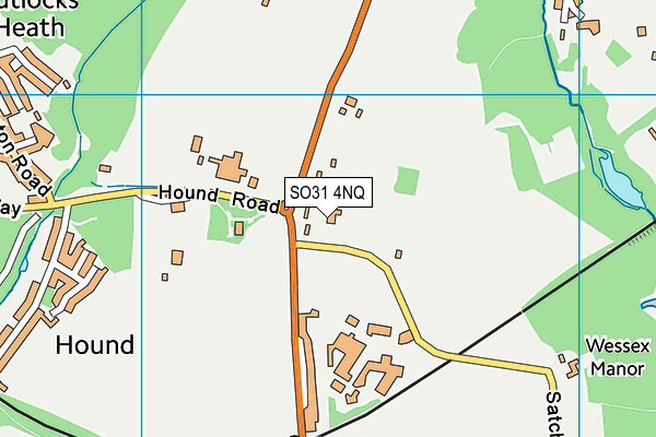
SO31 4NQ is located in the Bursledon & Hound North electoral ward, within the local authority district of Eastleigh and the English Parliamentary constituency of Eastleigh. The Sub Integrated Care Board (ICB) Location is NHS Hampshire and Isle of Wight ICB - D9Y0V and the police force is Hampshire. This postcode has been in use since September 2005.


GetTheData
Source: OS OpenMap – Local (Ordnance Survey)
Source: OS VectorMap District (Ordnance Survey)
Licence: Open Government Licence (requires attribution)
| Easting | 447433 |
| Northing | 108721 |
| Latitude | 50.876037 |
| Longitude | -1.327194 |
GetTheData
Source: Open Postcode Geo
Licence: Open Government Licence
| Country | England |
| Postcode District | SO31 |
➜ See where SO31 is on a map ➜ Where is Hound? | |
GetTheData
Source: Land Registry Price Paid Data
Licence: Open Government Licence
Elevation or altitude of SO31 4NQ as distance above sea level:
| Metres | Feet | |
|---|---|---|
| Elevation | 20m | 66ft |
Elevation is measured from the approximate centre of the postcode, to the nearest point on an OS contour line from OS Terrain 50, which has contour spacing of ten vertical metres.
➜ How high above sea level am I? Find the elevation of your current position using your device's GPS.
GetTheData
Source: Open Postcode Elevation
Licence: Open Government Licence
| Ward | Bursledon & Hound North |
| Constituency | Eastleigh |
GetTheData
Source: ONS Postcode Database
Licence: Open Government Licence
| Hound Farm (Hound Road) | Hound | 157m |
| Playing Field (Hamble Lane) | Hound | 161m |
| Playing Field (Hamble Lane) | Hound | 168m |
| Hound Farm (Hound Road) | Hound | 201m |
| Hamble Lane School (Hamble Lane) | Hound | 290m |
| Hamble Station | 0.5km |
| Netley Station | 1km |
| Bursledon Station | 1.8km |
GetTheData
Source: NaPTAN
Licence: Open Government Licence
GetTheData
Source: ONS Postcode Database
Licence: Open Government Licence


➜ Get more ratings from the Food Standards Agency
GetTheData
Source: Food Standards Agency
Licence: FSA terms & conditions
| Last Collection | |||
|---|---|---|---|
| Location | Mon-Fri | Sat | Distance |
| Hound Lane | 16:30 | 08:00 | 200m |
| Hound Road | 17:00 | 08:30 | 695m |
| Hungerford Bottom | 16:15 | 07:45 | 810m |
GetTheData
Source: Dracos
Licence: Creative Commons Attribution-ShareAlike
The below table lists the International Territorial Level (ITL) codes (formerly Nomenclature of Territorial Units for Statistics (NUTS) codes) and Local Administrative Units (LAU) codes for SO31 4NQ:
| ITL 1 Code | Name |
|---|---|
| TLJ | South East (England) |
| ITL 2 Code | Name |
| TLJ3 | Hampshire and Isle of Wight |
| ITL 3 Code | Name |
| TLJ35 | South Hampshire |
| LAU 1 Code | Name |
| E07000086 | Eastleigh |
GetTheData
Source: ONS Postcode Directory
Licence: Open Government Licence
The below table lists the Census Output Area (OA), Lower Layer Super Output Area (LSOA), and Middle Layer Super Output Area (MSOA) for SO31 4NQ:
| Code | Name | |
|---|---|---|
| OA | E00115339 | |
| LSOA | E01022689 | Eastleigh 015B |
| MSOA | E02004726 | Eastleigh 015 |
GetTheData
Source: ONS Postcode Directory
Licence: Open Government Licence
| SO31 5FT | Hamble Lane | 64m |
| SO31 5JS | Hound Road | 213m |
| SO31 5FS | Hound Road | 277m |
| SO31 4HT | Hamble Lane | 281m |
| SO31 4BT | Broad Way | 360m |
| SO31 5FW | Hound Road Gardens | 602m |
| SO31 5FU | Hound Road | 604m |
| SO31 4NL | Hamble Lane | 620m |
| SO31 4HS | Satchell Lane | 656m |
| SO31 5QX | Abbots Way | 701m |
GetTheData
Source: Open Postcode Geo; Land Registry Price Paid Data
Licence: Open Government Licence