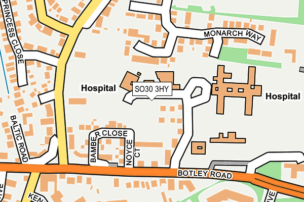
SO30 3HY is located in the West End North electoral ward, within the local authority district of Eastleigh and the English Parliamentary constituency of Eastleigh. The Sub Integrated Care Board (ICB) Location is NHS Hampshire and Isle of Wight ICB - D9Y0V and the police force is Hampshire. This postcode has been in use since April 2017.


GetTheData
Source: OS OpenMap – Local (Ordnance Survey)
Source: OS VectorMap District (Ordnance Survey)
Licence: Open Government Licence (requires attribution)
| Easting | 447501 |
| Northing | 114466 |
| Latitude | 50.927690 |
| Longitude | -1.325482 |
GetTheData
Source: Open Postcode Geo
Licence: Open Government Licence
| Country | England |
| Postcode District | SO30 |
➜ See where SO30 is on a map ➜ Where is West End? | |
GetTheData
Source: Land Registry Price Paid Data
Licence: Open Government Licence
| Ward | West End North |
| Constituency | Eastleigh |
GetTheData
Source: ONS Postcode Database
Licence: Open Government Licence
| Moorgreen Hospital (Botley Road) | West End | 92m |
| Moorgreen Road (Botley Road) | West End | 150m |
| Moorgreen Hospital (Moorgreen Road) | West End | 167m |
| Moorgreen Hospital (Botley Road) | West End | 172m |
| Moorgreen Hospital (Moorgreen Road) | West End | 176m |
| Hedge End Station | 2.2km |
| Southampton Airport Parkway Station | 3.7km |
| Bitterne Station | 3.8km |
GetTheData
Source: NaPTAN
Licence: Open Government Licence
| Percentage of properties with Next Generation Access | 100.0% |
| Percentage of properties with Superfast Broadband | 100.0% |
| Percentage of properties with Ultrafast Broadband | 100.0% |
| Percentage of properties with Full Fibre Broadband | 100.0% |
Superfast Broadband is between 30Mbps and 300Mbps
Ultrafast Broadband is > 300Mbps
| Percentage of properties unable to receive 2Mbps | 0.0% |
| Percentage of properties unable to receive 5Mbps | 0.0% |
| Percentage of properties unable to receive 10Mbps | 0.0% |
| Percentage of properties unable to receive 30Mbps | 0.0% |
GetTheData
Source: Ofcom
Licence: Ofcom Terms of Use (requires attribution)
GetTheData
Source: ONS Postcode Database
Licence: Open Government Licence

➜ Get more ratings from the Food Standards Agency
GetTheData
Source: Food Standards Agency
Licence: FSA terms & conditions
| Last Collection | |||
|---|---|---|---|
| Location | Mon-Fri | Sat | Distance |
| Sportsman | 16:45 | 07:30 | 176m |
| Chapel Road | 17:00 | 09:00 | 489m |
| Moorgreen | 16:45 | 07:30 | 638m |
GetTheData
Source: Dracos
Licence: Creative Commons Attribution-ShareAlike
The below table lists the International Territorial Level (ITL) codes (formerly Nomenclature of Territorial Units for Statistics (NUTS) codes) and Local Administrative Units (LAU) codes for SO30 3HY:
| ITL 1 Code | Name |
|---|---|
| TLJ | South East (England) |
| ITL 2 Code | Name |
| TLJ3 | Hampshire and Isle of Wight |
| ITL 3 Code | Name |
| TLJ35 | South Hampshire |
| LAU 1 Code | Name |
| E07000086 | Eastleigh |
GetTheData
Source: ONS Postcode Directory
Licence: Open Government Licence
The below table lists the Census Output Area (OA), Lower Layer Super Output Area (LSOA), and Middle Layer Super Output Area (MSOA) for SO30 3HY:
| Code | Name | |
|---|---|---|
| OA | E00115460 | |
| LSOA | E01022713 | Eastleigh 009A |
| MSOA | E02004720 | Eastleigh 009 |
GetTheData
Source: ONS Postcode Directory
Licence: Open Government Licence
| SO30 3HA | Botley Road | 79m |
| SO30 3HG | Botley Road | 114m |
| SO30 3JS | Yew Tree Court | 173m |
| SO30 3HH | Kenilworth Gardens | 207m |
| SO30 3JD | Sportsman Place | 208m |
| SO30 3EA | Moorgreen Road | 215m |
| SO30 3DY | High Street | 225m |
| SO30 3JQ | Monarch Way | 255m |
| SO30 3JR | Monarch Way | 268m |
| SO30 3DZ | Baltic Road | 270m |
GetTheData
Source: Open Postcode Geo; Land Registry Price Paid Data
Licence: Open Government Licence