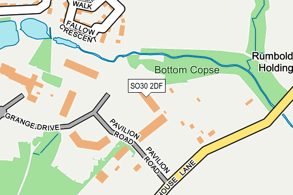
SO30 2DF is located in the Hedge End North electoral ward, within the local authority district of Eastleigh and the English Parliamentary constituency of Eastleigh. The Sub Integrated Care Board (ICB) Location is NHS Hampshire and Isle of Wight ICB - D9Y0V and the police force is Hampshire. This postcode has been in use since June 2002.


GetTheData
Source: OS OpenMap – Local (Ordnance Survey)
Source: OS VectorMap District (Ordnance Survey)
Licence: Open Government Licence (requires attribution)
| Easting | 450013 |
| Northing | 113627 |
| Latitude | 50.919934 |
| Longitude | -1.289856 |
GetTheData
Source: Open Postcode Geo
Licence: Open Government Licence
| Country | England |
| Postcode District | SO30 |
➜ See where SO30 is on a map ➜ Where is Hedge End? | |
GetTheData
Source: Land Registry Price Paid Data
Licence: Open Government Licence
Elevation or altitude of SO30 2DF as distance above sea level:
| Metres | Feet | |
|---|---|---|
| Elevation | 10m | 33ft |
Elevation is measured from the approximate centre of the postcode, to the nearest point on an OS contour line from OS Terrain 50, which has contour spacing of ten vertical metres.
➜ How high above sea level am I? Find the elevation of your current position using your device's GPS.
GetTheData
Source: Open Postcode Elevation
Licence: Open Government Licence
| Ward | Hedge End North |
| Constituency | Eastleigh |
GetTheData
Source: ONS Postcode Database
Licence: Open Government Licence
| Bowling Green (Woodhouse Lane) | Hedge End | 194m |
| Stag Drive (Fawn Crescent) | Wildern | 360m |
| Botleigh Lakeside (Fawn Crescent) | Wildern | 362m |
| Hilliers Garden Centre (Woodhouse Lane) | Boorley Green | 366m |
| Maypole (Grange Road) | Hedge End | 393m |
| Hedge End Station | 1.4km |
| Botley Station | 2.2km |
| Bursledon Station | 4.2km |
GetTheData
Source: NaPTAN
Licence: Open Government Licence
GetTheData
Source: ONS Postcode Database
Licence: Open Government Licence


➜ Get more ratings from the Food Standards Agency
GetTheData
Source: Food Standards Agency
Licence: FSA terms & conditions
| Last Collection | |||
|---|---|---|---|
| Location | Mon-Fri | Sat | Distance |
| Maypole Rest Home | 16:45 | 08:45 | 479m |
| Locke Road | 16:45 | 07:30 | 655m |
| Hobb Lane | 16:45 | 09:00 | 718m |
GetTheData
Source: Dracos
Licence: Creative Commons Attribution-ShareAlike
The below table lists the International Territorial Level (ITL) codes (formerly Nomenclature of Territorial Units for Statistics (NUTS) codes) and Local Administrative Units (LAU) codes for SO30 2DF:
| ITL 1 Code | Name |
|---|---|
| TLJ | South East (England) |
| ITL 2 Code | Name |
| TLJ3 | Hampshire and Isle of Wight |
| ITL 3 Code | Name |
| TLJ35 | South Hampshire |
| LAU 1 Code | Name |
| E07000086 | Eastleigh |
GetTheData
Source: ONS Postcode Directory
Licence: Open Government Licence
The below table lists the Census Output Area (OA), Lower Layer Super Output Area (LSOA), and Middle Layer Super Output Area (MSOA) for SO30 2DF:
| Code | Name | |
|---|---|---|
| OA | E00115349 | |
| LSOA | E01022694 | Eastleigh 010E |
| MSOA | E02004721 | Eastleigh 010 |
GetTheData
Source: ONS Postcode Directory
Licence: Open Government Licence
| SO30 2EZ | Woodhouse Lane | 149m |
| SO30 2QN | Stag Drive | 215m |
| SO30 2QB | Deer Walk | 218m |
| SO30 2QG | Fallow Crescent | 251m |
| SO30 2QQ | Fallow Crescent | 255m |
| SO30 2QW | Stag Drive | 327m |
| SO30 2QD | Fawn Crescent | 338m |
| SO30 2QE | Doe Walk | 356m |
| SO30 2JQ | Broad Oak | 371m |
| SO30 2FB | Grange Road | 374m |
GetTheData
Source: Open Postcode Geo; Land Registry Price Paid Data
Licence: Open Government Licence