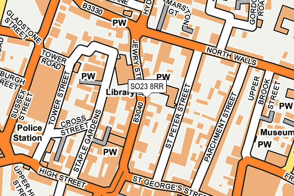
SO23 8RR is located in the St Michael electoral ward, within the local authority district of Winchester and the English Parliamentary constituency of Winchester. The Sub Integrated Care Board (ICB) Location is NHS Hampshire and Isle of Wight ICB - D9Y0V and the police force is Hampshire. This postcode has been in use since May 2017.


GetTheData
Source: OS OpenMap – Local (Ordnance Survey)
Source: OS VectorMap District (Ordnance Survey)
Licence: Open Government Licence (requires attribution)
| Easting | 448050 |
| Northing | 129697 |
| Latitude | 51.064599 |
| Longitude | -1.315659 |
GetTheData
Source: Open Postcode Geo
Licence: Open Government Licence
| Country | England |
| Postcode District | SO23 |
➜ See where SO23 is on a map ➜ Where is Winchester? | |
GetTheData
Source: Land Registry Price Paid Data
Licence: Open Government Licence
| Ward | St Michael |
| Constituency | Winchester |
GetTheData
Source: ONS Postcode Database
Licence: Open Government Licence
| Discovery Centre (Jewry Street) | Winchester | 62m |
| Jewry Street | Winchester | 73m |
| Discovery Centre (Jewry Street) | Winchester | 79m |
| Jewry Street | Winchester | 171m |
| City Road | Winchester | 193m |
| Winchester Station | 0.4km |
| Shawford Station | 4.8km |
GetTheData
Source: NaPTAN
Licence: Open Government Licence
Estimated total energy consumption in SO23 8RR by fuel type, 2015.
| Consumption (kWh) | 46,034 |
|---|---|
| Meter count | 7 |
| Mean (kWh/meter) | 6,576 |
| Median (kWh/meter) | 5,813 |
GetTheData
Source: Postcode level gas estimates: 2015 (experimental)
Source: Postcode level electricity estimates: 2015 (experimental)
Licence: Open Government Licence
GetTheData
Source: ONS Postcode Database
Licence: Open Government Licence


➜ Get more ratings from the Food Standards Agency
GetTheData
Source: Food Standards Agency
Licence: FSA terms & conditions
| Last Collection | |||
|---|---|---|---|
| Location | Mon-Fri | Sat | Distance |
| Jewry Street | 18:30 | 11:00 | 21m |
| City Road | 18:30 | 12:00 | 192m |
| High Street | 17:45 | 11:00 | 215m |
GetTheData
Source: Dracos
Licence: Creative Commons Attribution-ShareAlike
The below table lists the International Territorial Level (ITL) codes (formerly Nomenclature of Territorial Units for Statistics (NUTS) codes) and Local Administrative Units (LAU) codes for SO23 8RR:
| ITL 1 Code | Name |
|---|---|
| TLJ | South East (England) |
| ITL 2 Code | Name |
| TLJ3 | Hampshire and Isle of Wight |
| ITL 3 Code | Name |
| TLJ36 | Central Hampshire |
| LAU 1 Code | Name |
| E07000094 | Winchester |
GetTheData
Source: ONS Postcode Directory
Licence: Open Government Licence
The below table lists the Census Output Area (OA), Lower Layer Super Output Area (LSOA), and Middle Layer Super Output Area (MSOA) for SO23 8RR:
| Code | Name | |
|---|---|---|
| OA | E00118153 | |
| LSOA | E01023252 | Winchester 007A |
| MSOA | E02004835 | Winchester 007 |
GetTheData
Source: ONS Postcode Directory
Licence: Open Government Licence
| SO23 8RY | Jewry Street | 28m |
| SO23 8FE | Jewry Street | 31m |
| SO23 8BW | St Peter Street | 63m |
| SO23 8FJ | Exchange Square | 73m |
| SO23 8RZ | Jewry Street | 85m |
| SO23 8GW | Sutton Gardens | 88m |
| SO23 8RS | Staple Gardens | 95m |
| SO23 8HP | Sutton Gardens | 105m |
| SO23 8SR | Staple Gardens | 110m |
| SO23 8SP | Staple Gardens | 118m |
GetTheData
Source: Open Postcode Geo; Land Registry Price Paid Data
Licence: Open Government Licence