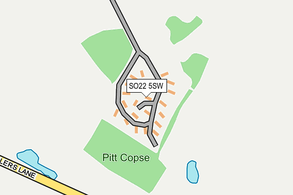
SO22 5SW is located in the Badger Farm and Oliver's Battery electoral ward, within the local authority district of Winchester and the English Parliamentary constituency of Winchester. The Sub Integrated Care Board (ICB) Location is NHS Hampshire and Isle of Wight ICB - D9Y0V and the police force is Hampshire. This postcode has been in use since July 2006.


GetTheData
Source: OS OpenMap – Local (Ordnance Survey)
Source: OS VectorMap District (Ordnance Survey)
Licence: Open Government Licence (requires attribution)
| Easting | 444940 |
| Northing | 127430 |
| Latitude | 51.044472 |
| Longitude | -1.360330 |
GetTheData
Source: Open Postcode Geo
Licence: Open Government Licence
| Country | England |
| Postcode District | SO22 |
➜ See where SO22 is on a map | |
GetTheData
Source: Land Registry Price Paid Data
Licence: Open Government Licence
Elevation or altitude of SO22 5SW as distance above sea level:
| Metres | Feet | |
|---|---|---|
| Elevation | 100m | 328ft |
Elevation is measured from the approximate centre of the postcode, to the nearest point on an OS contour line from OS Terrain 50, which has contour spacing of ten vertical metres.
➜ How high above sea level am I? Find the elevation of your current position using your device's GPS.
GetTheData
Source: Open Postcode Elevation
Licence: Open Government Licence
| Ward | Badger Farm And Oliver's Battery |
| Constituency | Winchester |
GetTheData
Source: ONS Postcode Database
Licence: Open Government Licence
| Yew Tree Cottage (A3090) | Pitt | 438m |
| Yew Tree Cottage (A3090) | Pitt | 449m |
| Sunnydown Road (Old Kennels Lane) | Oliver's Battery | 510m |
| Sunnydown Road | Oliver's Battery | 531m |
| Millers Lane (A3090) | Pitt | 602m |
| Shawford Station | 3.4km |
| Winchester Station | 3.8km |
GetTheData
Source: NaPTAN
Licence: Open Government Licence
Estimated total energy consumption in SO22 5SW by fuel type, 2015.
| Consumption (kWh) | 164,195 |
|---|---|
| Meter count | 11 |
| Mean (kWh/meter) | 14,927 |
| Median (kWh/meter) | 15,268 |
GetTheData
Source: Postcode level gas estimates: 2015 (experimental)
Source: Postcode level electricity estimates: 2015 (experimental)
Licence: Open Government Licence
GetTheData
Source: ONS Postcode Database
Licence: Open Government Licence


➜ Get more ratings from the Food Standards Agency
GetTheData
Source: Food Standards Agency
Licence: FSA terms & conditions
| Last Collection | |||
|---|---|---|---|
| Location | Mon-Fri | Sat | Distance |
| Old Kennels Lane | 16:00 | 11:00 | 584m |
| Pitt | 16:00 | 07:00 | 611m |
| Battery Hill | 17:30 | 11:45 | 757m |
GetTheData
Source: Dracos
Licence: Creative Commons Attribution-ShareAlike
The below table lists the International Territorial Level (ITL) codes (formerly Nomenclature of Territorial Units for Statistics (NUTS) codes) and Local Administrative Units (LAU) codes for SO22 5SW:
| ITL 1 Code | Name |
|---|---|
| TLJ | South East (England) |
| ITL 2 Code | Name |
| TLJ3 | Hampshire and Isle of Wight |
| ITL 3 Code | Name |
| TLJ36 | Central Hampshire |
| LAU 1 Code | Name |
| E07000094 | Winchester |
GetTheData
Source: ONS Postcode Directory
Licence: Open Government Licence
The below table lists the Census Output Area (OA), Lower Layer Super Output Area (LSOA), and Middle Layer Super Output Area (MSOA) for SO22 5SW:
| Code | Name | |
|---|---|---|
| OA | E00118030 | |
| LSOA | E01023229 | Winchester 009A |
| MSOA | E02004837 | Winchester 009 |
GetTheData
Source: ONS Postcode Directory
Licence: Open Government Licence
| SO22 4LB | Old Kennels Close | 438m |
| SO22 4BF | Fairway Drive | 445m |
| SO22 5QP | 465m | |
| SO22 4LD | Sunnydown Road | 471m |
| SO22 4JS | Old Kennels Lane | 520m |
| SO22 4JT | Old Kennels Lane | 535m |
| SO22 4PB | Lake Drive | 543m |
| SO22 4JZ | Lisle Close | 583m |
| SO22 4JR | Old Kennels Lane | 584m |
| SO22 5QX | Romsey Road | 585m |
GetTheData
Source: Open Postcode Geo; Land Registry Price Paid Data
Licence: Open Government Licence