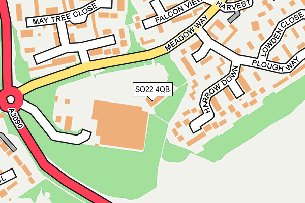
SO22 4QB lies on The Croft in Winchester. SO22 4QB is located in the Badger Farm and Oliver's Battery electoral ward, within the local authority district of Winchester and the English Parliamentary constituency of Winchester. The Sub Integrated Care Board (ICB) Location is NHS Hampshire and Isle of Wight ICB - D9Y0V and the police force is Hampshire. This postcode has been in use since April 1987.


GetTheData
Source: OS OpenMap – Local (Ordnance Survey)
Source: OS VectorMap District (Ordnance Survey)
Licence: Open Government Licence (requires attribution)
| Easting | 446349 |
| Northing | 127588 |
| Latitude | 51.045775 |
| Longitude | -1.340202 |
GetTheData
Source: Open Postcode Geo
Licence: Open Government Licence
| Street | The Croft |
| Town/City | Winchester |
| Country | England |
| Postcode District | SO22 |
➜ See where SO22 is on a map ➜ Where is Winchester? | |
GetTheData
Source: Land Registry Price Paid Data
Licence: Open Government Licence
Elevation or altitude of SO22 4QB as distance above sea level:
| Metres | Feet | |
|---|---|---|
| Elevation | 80m | 262ft |
Elevation is measured from the approximate centre of the postcode, to the nearest point on an OS contour line from OS Terrain 50, which has contour spacing of ten vertical metres.
➜ How high above sea level am I? Find the elevation of your current position using your device's GPS.
GetTheData
Source: Open Postcode Elevation
Licence: Open Government Licence
| Ward | Badger Farm And Oliver's Battery |
| Constituency | Winchester |
GetTheData
Source: ONS Postcode Database
Licence: Open Government Licence
1, THE CROFT, WINCHESTER, SO22 4QB 2016 13 JUN £620,000 |
3, THE CROFT, WINCHESTER, SO22 4QB 2015 11 DEC £670,000 |
GetTheData
Source: HM Land Registry Price Paid Data
Licence: Contains HM Land Registry data © Crown copyright and database right 2025. This data is licensed under the Open Government Licence v3.0.
| Sainsburys Store (In Store Grounds) | Badger Farm | 59m |
| Sainsburys (Meadow Way) | Badger Farm | 135m |
| Meadow Way Subway (Meadow Way) | Badger Farm | 168m |
| Barley Down Drive (Meadow Way) | Badger Farm | 424m |
| Austen Avenue (Compton Way) | Oliver's Battery | 441m |
| Shawford Station | 2.8km |
| Winchester Station | 2.8km |
GetTheData
Source: NaPTAN
Licence: Open Government Licence
Estimated total energy consumption in SO22 4QB by fuel type, 2015.
| Consumption (kWh) | 97,342 |
|---|---|
| Meter count | 7 |
| Mean (kWh/meter) | 13,906 |
| Median (kWh/meter) | 9,578 |
| Consumption (kWh) | 9,876 |
|---|---|
| Meter count | 7 |
| Mean (kWh/meter) | 1,411 |
| Median (kWh/meter) | 1,659 |
GetTheData
Source: Postcode level gas estimates: 2015 (experimental)
Source: Postcode level electricity estimates: 2015 (experimental)
Licence: Open Government Licence
GetTheData
Source: ONS Postcode Database
Licence: Open Government Licence


➜ Get more ratings from the Food Standards Agency
GetTheData
Source: Food Standards Agency
Licence: FSA terms & conditions
| Last Collection | |||
|---|---|---|---|
| Location | Mon-Fri | Sat | Distance |
| Sainsburys | 16:45 | 12:00 | 65m |
| Maytree Close | 16:00 | 11:00 | 163m |
| Elder Close | 16:00 | 11:00 | 431m |
GetTheData
Source: Dracos
Licence: Creative Commons Attribution-ShareAlike
The below table lists the International Territorial Level (ITL) codes (formerly Nomenclature of Territorial Units for Statistics (NUTS) codes) and Local Administrative Units (LAU) codes for SO22 4QB:
| ITL 1 Code | Name |
|---|---|
| TLJ | South East (England) |
| ITL 2 Code | Name |
| TLJ3 | Hampshire and Isle of Wight |
| ITL 3 Code | Name |
| TLJ36 | Central Hampshire |
| LAU 1 Code | Name |
| E07000094 | Winchester |
GetTheData
Source: ONS Postcode Directory
Licence: Open Government Licence
The below table lists the Census Output Area (OA), Lower Layer Super Output Area (LSOA), and Middle Layer Super Output Area (MSOA) for SO22 4QB:
| Code | Name | |
|---|---|---|
| OA | E00118098 | |
| LSOA | E01023243 | Winchester 009C |
| MSOA | E02004837 | Winchester 009 |
GetTheData
Source: ONS Postcode Directory
Licence: Open Government Licence
| SO22 4LY | Fallow Field | 182m |
| SO22 4LZ | Harrow Down | 188m |
| SO22 4JE | May Tree Close | 220m |
| SO22 4HR | Keats Close | 257m |
| SO22 4JF | May Tree Close | 260m |
| SO22 4EP | Falcon View | 260m |
| SO22 4QS | Parliament Place | 312m |
| SO22 4DW | Harvest Close | 337m |
| SO22 4HP | Austen Avenue | 340m |
| SO22 4PW | Plough Way | 354m |
GetTheData
Source: Open Postcode Geo; Land Registry Price Paid Data
Licence: Open Government Licence