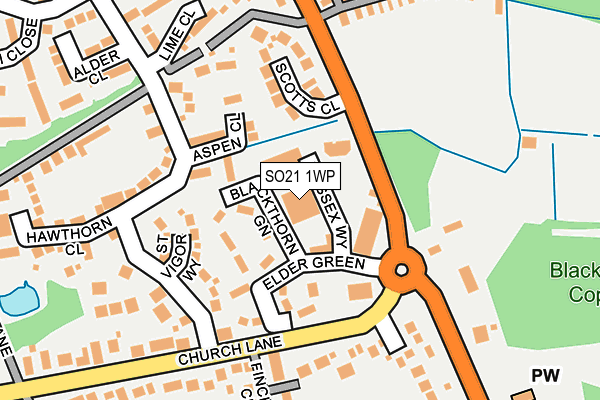
SO21 1WP lies on Wessex Business Park in Colden Common, Winchester. SO21 1WP is located in the Colden Common and Twyford electoral ward, within the local authority district of Winchester and the English Parliamentary constituency of Winchester. The Sub Integrated Care Board (ICB) Location is NHS Hampshire and Isle of Wight ICB - D9Y0V and the police force is Hampshire. This postcode has been in use since December 1994.


GetTheData
Source: OS OpenMap – Local (Ordnance Survey)
Source: OS VectorMap District (Ordnance Survey)
Licence: Open Government Licence (requires attribution)
| Easting | 448412 |
| Northing | 121753 |
| Latitude | 50.993139 |
| Longitude | -1.311552 |
GetTheData
Source: Open Postcode Geo
Licence: Open Government Licence
| Street | Wessex Business Park |
| Locality | Colden Common |
| Town/City | Winchester |
| Country | England |
| Postcode District | SO21 |
➜ See where SO21 is on a map ➜ Where is Colden Common? | |
GetTheData
Source: Land Registry Price Paid Data
Licence: Open Government Licence
Elevation or altitude of SO21 1WP as distance above sea level:
| Metres | Feet | |
|---|---|---|
| Elevation | 40m | 131ft |
Elevation is measured from the approximate centre of the postcode, to the nearest point on an OS contour line from OS Terrain 50, which has contour spacing of ten vertical metres.
➜ How high above sea level am I? Find the elevation of your current position using your device's GPS.
GetTheData
Source: Open Postcode Elevation
Licence: Open Government Licence
| Ward | Colden Common And Twyford |
| Constituency | Winchester |
GetTheData
Source: ONS Postcode Database
Licence: Open Government Licence
| St Vigor Way (Church Lane) | Colden Common | 129m |
| Vears Lane (B3354 Main Road) | Colden Common | 145m |
| St Vigor Way (Church Lane) | Colden Common | 147m |
| Vears Lane (B3354 Main Road) | Colden Common | 203m |
| Woodside Centre (B3354 Main Road) | Nob's Crook | 337m |
| Shawford Station | 3.4km |
| Eastleigh Station | 3.8km |
| Southampton Airport Parkway Station | 5.9km |
GetTheData
Source: NaPTAN
Licence: Open Government Licence
Estimated total energy consumption in SO21 1WP by fuel type, 2015.
| Consumption (kWh) | 177,486 |
|---|---|
| Meter count | 8 |
| Mean (kWh/meter) | 22,186 |
| Median (kWh/meter) | 18,015 |
GetTheData
Source: Postcode level gas estimates: 2015 (experimental)
Source: Postcode level electricity estimates: 2015 (experimental)
Licence: Open Government Licence
GetTheData
Source: ONS Postcode Database
Licence: Open Government Licence


➜ Get more ratings from the Food Standards Agency
GetTheData
Source: Food Standards Agency
Licence: FSA terms & conditions
| Last Collection | |||
|---|---|---|---|
| Location | Mon-Fri | Sat | Distance |
| The Glen | 16:00 | 10:30 | 184m |
| St Vigor Way | 16:15 | 11:00 | 431m |
| Brickmakers Road | 16:15 | 10:30 | 519m |
GetTheData
Source: Dracos
Licence: Creative Commons Attribution-ShareAlike
The below table lists the International Territorial Level (ITL) codes (formerly Nomenclature of Territorial Units for Statistics (NUTS) codes) and Local Administrative Units (LAU) codes for SO21 1WP:
| ITL 1 Code | Name |
|---|---|
| TLJ | South East (England) |
| ITL 2 Code | Name |
| TLJ3 | Hampshire and Isle of Wight |
| ITL 3 Code | Name |
| TLJ36 | Central Hampshire |
| LAU 1 Code | Name |
| E07000094 | Winchester |
GetTheData
Source: ONS Postcode Directory
Licence: Open Government Licence
The below table lists the Census Output Area (OA), Lower Layer Super Output Area (LSOA), and Middle Layer Super Output Area (MSOA) for SO21 1WP:
| Code | Name | |
|---|---|---|
| OA | E00118017 | |
| LSOA | E01023227 | Winchester 010B |
| MSOA | E02004838 | Winchester 010 |
GetTheData
Source: ONS Postcode Directory
Licence: Open Government Licence
| SO21 1UW | Aspen Close | 105m |
| SO21 1US | Scotts Close | 118m |
| SO21 1SY | Church Lane | 170m |
| SO21 1UU | St Vigor Way | 182m |
| SO21 1SZ | Brambles Close | 187m |
| SO21 1TW | Church Lane | 193m |
| SO21 1WN | Lime Close | 204m |
| SO21 1TP | Church Lane | 238m |
| SO21 1TQ | Vears Lane | 257m |
| SO21 1XB | Alder Close | 259m |
GetTheData
Source: Open Postcode Geo; Land Registry Price Paid Data
Licence: Open Government Licence