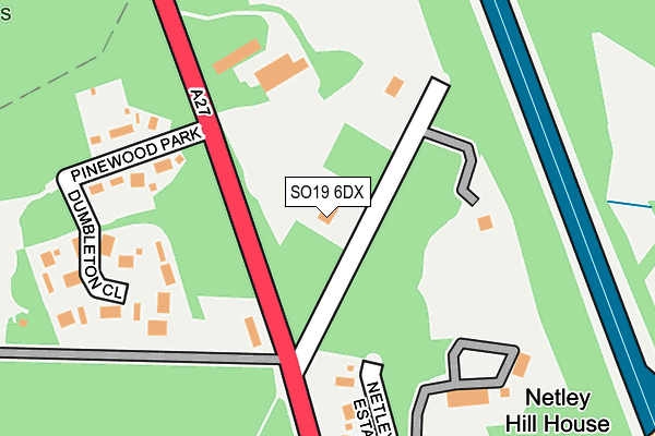
SO19 6DX lies on Netley Firs Close in Southampton. SO19 6DX is located in the Hedge End South electoral ward, within the local authority district of Eastleigh and the English Parliamentary constituency of Eastleigh. The Sub Integrated Care Board (ICB) Location is NHS Hampshire and Isle of Wight ICB - D9Y0V and the police force is Hampshire. This postcode has been in use since December 1994.


GetTheData
Source: OS OpenMap – Local (Ordnance Survey)
Source: OS VectorMap District (Ordnance Survey)
Licence: Open Government Licence (requires attribution)
| Easting | 447937 |
| Northing | 111999 |
| Latitude | 50.905480 |
| Longitude | -1.319613 |
GetTheData
Source: Open Postcode Geo
Licence: Open Government Licence
| Street | Netley Firs Close |
| Town/City | Southampton |
| Country | England |
| Postcode District | SO19 |
➜ See where SO19 is on a map | |
GetTheData
Source: Land Registry Price Paid Data
Licence: Open Government Licence
Elevation or altitude of SO19 6DX as distance above sea level:
| Metres | Feet | |
|---|---|---|
| Elevation | 70m | 230ft |
Elevation is measured from the approximate centre of the postcode, to the nearest point on an OS contour line from OS Terrain 50, which has contour spacing of ten vertical metres.
➜ How high above sea level am I? Find the elevation of your current position using your device's GPS.
GetTheData
Source: Open Postcode Elevation
Licence: Open Government Licence
| Ward | Hedge End South |
| Constituency | Eastleigh |
GetTheData
Source: ONS Postcode Database
Licence: Open Government Licence
| Foord Road (St John's Road) | Netley Hill | 506m |
| Foord Road (St John's Road) | Netley Hill | 539m |
| Holcroft Road (Hinkler Road) | Thornhill | 705m |
| Ellis Road (Hinkler Road) | Thornhill | 711m |
| Ellis Road (Hinkler Road) | Thornhill | 713m |
| Bursledon Station | 2.6km |
| Sholing Station | 3.3km |
| Hedge End Station | 3.5km |
GetTheData
Source: NaPTAN
Licence: Open Government Licence
| Percentage of properties with Next Generation Access | 100.0% |
| Percentage of properties with Superfast Broadband | 100.0% |
| Percentage of properties with Ultrafast Broadband | 0.0% |
| Percentage of properties with Full Fibre Broadband | 0.0% |
Superfast Broadband is between 30Mbps and 300Mbps
Ultrafast Broadband is > 300Mbps
| Percentage of properties unable to receive 2Mbps | 0.0% |
| Percentage of properties unable to receive 5Mbps | 0.0% |
| Percentage of properties unable to receive 10Mbps | 0.0% |
| Percentage of properties unable to receive 30Mbps | 0.0% |
GetTheData
Source: Ofcom
Licence: Ofcom Terms of Use (requires attribution)
GetTheData
Source: ONS Postcode Database
Licence: Open Government Licence


➜ Get more ratings from the Food Standards Agency
GetTheData
Source: Food Standards Agency
Licence: FSA terms & conditions
| Last Collection | |||
|---|---|---|---|
| Location | Mon-Fri | Sat | Distance |
| Netley Hill | 18:00 | 11:30 | 294m |
| Pewitt Hill | 16:00 | 07:30 | 730m |
| Alexandra Road | 16:45 | 08:00 | 756m |
GetTheData
Source: Dracos
Licence: Creative Commons Attribution-ShareAlike
The below table lists the International Territorial Level (ITL) codes (formerly Nomenclature of Territorial Units for Statistics (NUTS) codes) and Local Administrative Units (LAU) codes for SO19 6DX:
| ITL 1 Code | Name |
|---|---|
| TLJ | South East (England) |
| ITL 2 Code | Name |
| TLJ3 | Hampshire and Isle of Wight |
| ITL 3 Code | Name |
| TLJ35 | South Hampshire |
| LAU 1 Code | Name |
| E07000086 | Eastleigh |
GetTheData
Source: ONS Postcode Directory
Licence: Open Government Licence
The below table lists the Census Output Area (OA), Lower Layer Super Output Area (LSOA), and Middle Layer Super Output Area (MSOA) for SO19 6DX:
| Code | Name | |
|---|---|---|
| OA | E00115368 | |
| LSOA | E01022698 | Eastleigh 012D |
| MSOA | E02004723 | Eastleigh 012 |
GetTheData
Source: ONS Postcode Directory
Licence: Open Government Licence
| SO19 6AL | Pinewood Park | 197m |
| SO19 6AN | Netley Hill Estate | 207m |
| SO19 6AP | Dumbleton Close | 220m |
| SO30 4BH | Woodside Way | 475m |
| SO19 6AY | Copse View | 503m |
| SO30 4DF | St Johns Road | 515m |
| SO30 0DR | Foord Road | 517m |
| SO31 8BN | West End Road | 518m |
| SO30 4AS | Granada Road | 528m |
| SO30 4QQ | Firs Drive | 530m |
GetTheData
Source: Open Postcode Geo; Land Registry Price Paid Data
Licence: Open Government Licence