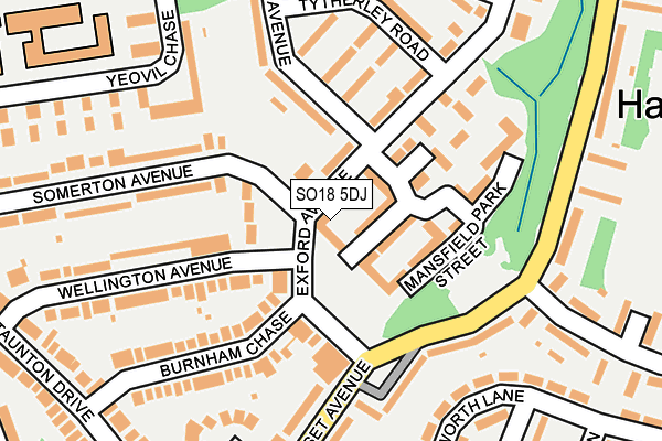
SO18 5DJ lies on Exford Avenue in Southampton. SO18 5DJ is located in the Harefield electoral ward, within the unitary authority of Southampton and the English Parliamentary constituency of Southampton, Itchen. The Sub Integrated Care Board (ICB) Location is NHS Hampshire and Isle of Wight ICB - D9Y0V and the police force is Hampshire. This postcode has been in use since July 2017.


GetTheData
Source: OS OpenMap – Local (Ordnance Survey)
Source: OS VectorMap District (Ordnance Survey)
Licence: Open Government Licence (requires attribution)
| Easting | 446175 |
| Northing | 113449 |
| Latitude | 50.918652 |
| Longitude | -1.344477 |
GetTheData
Source: Open Postcode Geo
Licence: Open Government Licence
| Street | Exford Avenue |
| Town/City | Southampton |
| Country | England |
| Postcode District | SO18 |
➜ See where SO18 is on a map ➜ Where is Southampton? | |
GetTheData
Source: Land Registry Price Paid Data
Licence: Open Government Licence
| Ward | Harefield |
| Constituency | Southampton, Itchen |
GetTheData
Source: ONS Postcode Database
Licence: Open Government Licence
| The Exford Arms (Somerset Avenue) | Harefield | 131m |
| The Exford Arms (Somerset Avenue) | Harefield | 168m |
| Somerset Avenue (Cheriton Avenue) | Harefield | 226m |
| Somerset Avenue (Cheriton Avenue) | Harefield | 273m |
| Burnham Chase (Taunton Drive) | Bitterne | 285m |
| Bitterne Station | 2.3km |
| Sholing Station | 2.8km |
| St Denys Station | 3.1km |
GetTheData
Source: NaPTAN
Licence: Open Government Licence
| Percentage of properties with Next Generation Access | 100.0% |
| Percentage of properties with Superfast Broadband | 100.0% |
| Percentage of properties with Ultrafast Broadband | 0.0% |
| Percentage of properties with Full Fibre Broadband | 0.0% |
Superfast Broadband is between 30Mbps and 300Mbps
Ultrafast Broadband is > 300Mbps
| Median download speed | 50.0Mbps |
| Average download speed | 59.6Mbps |
| Maximum download speed | 100.00Mbps |
| Median upload speed | 1.3Mbps |
| Average upload speed | 3.0Mbps |
| Maximum upload speed | 6.82Mbps |
| Percentage of properties unable to receive 2Mbps | 0.0% |
| Percentage of properties unable to receive 5Mbps | 0.0% |
| Percentage of properties unable to receive 10Mbps | 0.0% |
| Percentage of properties unable to receive 30Mbps | 0.0% |
GetTheData
Source: Ofcom
Licence: Ofcom Terms of Use (requires attribution)
GetTheData
Source: ONS Postcode Database
Licence: Open Government Licence


➜ Get more ratings from the Food Standards Agency
GetTheData
Source: Food Standards Agency
Licence: FSA terms & conditions
| Last Collection | |||
|---|---|---|---|
| Location | Mon-Fri | Sat | Distance |
| Harefield Post Office | 17:00 | 12:00 | 137m |
| Beauworth Avenue | 17:30 | 11:45 | 373m |
| Mon Crescent | 17:30 | 11:00 | 421m |
GetTheData
Source: Dracos
Licence: Creative Commons Attribution-ShareAlike
The below table lists the International Territorial Level (ITL) codes (formerly Nomenclature of Territorial Units for Statistics (NUTS) codes) and Local Administrative Units (LAU) codes for SO18 5DJ:
| ITL 1 Code | Name |
|---|---|
| TLJ | South East (England) |
| ITL 2 Code | Name |
| TLJ3 | Hampshire and Isle of Wight |
| ITL 3 Code | Name |
| TLJ32 | Southampton |
| LAU 1 Code | Name |
| E06000045 | Southampton |
GetTheData
Source: ONS Postcode Directory
Licence: Open Government Licence
The below table lists the Census Output Area (OA), Lower Layer Super Output Area (LSOA), and Middle Layer Super Output Area (MSOA) for SO18 5DJ:
| Code | Name | |
|---|---|---|
| OA | E00086877 | |
| LSOA | E01017205 | Southampton 018C |
| MSOA | E02003566 | Southampton 018 |
GetTheData
Source: ONS Postcode Directory
Licence: Open Government Licence
| SO18 5DP | Exford Avenue | 55m |
| SO18 5DE | Exford Avenue | 75m |
| SO18 5DR | Exford Avenue | 123m |
| SO18 5AE | Mansfield Park Street | 125m |
| SO18 5DY | Selborne Walk | 147m |
| SO18 5FS | Somerset Avenue | 161m |
| SO18 5DF | Burnham Chase | 164m |
| SO18 5DX | Tytherley Road | 165m |
| SO18 5DD | Wellington Avenue | 181m |
| SO18 5DZ | Selborne Avenue | 182m |
GetTheData
Source: Open Postcode Geo; Land Registry Price Paid Data
Licence: Open Government Licence