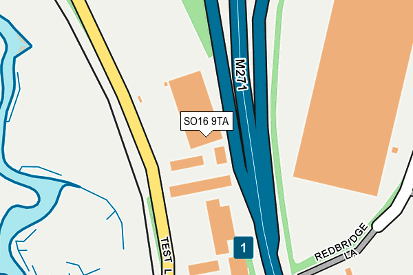
SO16 9TA lies on Test Lane in Southampton. SO16 9TA is located in the Chilworth, Nursling & Rownhams electoral ward, within the local authority district of Test Valley and the English Parliamentary constituency of Romsey and Southampton North. The Sub Integrated Care Board (ICB) Location is NHS Hampshire and Isle of Wight ICB - D9Y0V and the police force is Hampshire. This postcode has been in use since June 1997.


GetTheData
Source: OS OpenMap – Local (Ordnance Survey)
Source: OS VectorMap District (Ordnance Survey)
Licence: Open Government Licence (requires attribution)
| Easting | 437041 |
| Northing | 114746 |
| Latitude | 50.930981 |
| Longitude | -1.474289 |
GetTheData
Source: Open Postcode Geo
Licence: Open Government Licence
| Street | Test Lane |
| Town/City | Southampton |
| Country | England |
| Postcode District | SO16 |
➜ See where SO16 is on a map ➜ Where is Southampton? | |
GetTheData
Source: Land Registry Price Paid Data
Licence: Open Government Licence
Elevation or altitude of SO16 9TA as distance above sea level:
| Metres | Feet | |
|---|---|---|
| Elevation | 10m | 33ft |
Elevation is measured from the approximate centre of the postcode, to the nearest point on an OS contour line from OS Terrain 50, which has contour spacing of ten vertical metres.
➜ How high above sea level am I? Find the elevation of your current position using your device's GPS.
GetTheData
Source: Open Postcode Elevation
Licence: Open Government Licence
| Ward | Chilworth, Nursling & Rownhams |
| Constituency | Romsey And Southampton North |
GetTheData
Source: ONS Postcode Database
Licence: Open Government Licence
| Mauretania Road | Nursling | 569m |
| Adanac Park (Adanac Drive) | Adanac Park | 606m |
| The Saints (Kendal Avenue) | Millbrook Estate | 811m |
| Sedbergh Road (Kendal Avenue) | Millbrook Estate | 843m |
| The Saints (Windermere Avenue) | Millbrook Estate | 850m |
| Redbridge (Hants) Station | 1.3km |
| Totton Station | 1.6km |
| Millbrook (Hants) Station | 3.6km |
GetTheData
Source: NaPTAN
Licence: Open Government Licence
GetTheData
Source: ONS Postcode Database
Licence: Open Government Licence


➜ Get more ratings from the Food Standards Agency
GetTheData
Source: Food Standards Agency
Licence: FSA terms & conditions
| Last Collection | |||
|---|---|---|---|
| Location | Mon-Fri | Sat | Distance |
| Nursling Industrial Estate | 19:00 | 11:00 | 498m |
| Nursling Industrial Estate | 18:45 | 512m | |
| Redbridge Lane | 16:00 | 11:00 | 1,021m |
GetTheData
Source: Dracos
Licence: Creative Commons Attribution-ShareAlike
The below table lists the International Territorial Level (ITL) codes (formerly Nomenclature of Territorial Units for Statistics (NUTS) codes) and Local Administrative Units (LAU) codes for SO16 9TA:
| ITL 1 Code | Name |
|---|---|
| TLJ | South East (England) |
| ITL 2 Code | Name |
| TLJ3 | Hampshire and Isle of Wight |
| ITL 3 Code | Name |
| TLJ36 | Central Hampshire |
| LAU 1 Code | Name |
| E07000093 | Test Valley |
GetTheData
Source: ONS Postcode Directory
Licence: Open Government Licence
The below table lists the Census Output Area (OA), Lower Layer Super Output Area (LSOA), and Middle Layer Super Output Area (MSOA) for SO16 9TA:
| Code | Name | |
|---|---|---|
| OA | E00117746 | |
| LSOA | E01023170 | Test Valley 015A |
| MSOA | E02004828 | Test Valley 015 |
GetTheData
Source: ONS Postcode Directory
Licence: Open Government Licence
| SO16 9JW | Test Valley Business Centre | 39m |
| SO16 9JX | Yeoman Industrial Park | 187m |
| SO16 0AW | Brownhill Way | 337m |
| SO16 9JD | Porlock Road | 483m |
| SO16 9JE | Thorness Close | 575m |
| SO16 9LN | Mansel Road West | 577m |
| SO16 9JF | Porlock Road | 582m |
| SO16 9JB | Porlock Road | 598m |
| SO16 9LJ | Lower Brownhill Road | 600m |
| SO16 9HU | Seacombe Green | 616m |
GetTheData
Source: Open Postcode Geo; Land Registry Price Paid Data
Licence: Open Government Licence