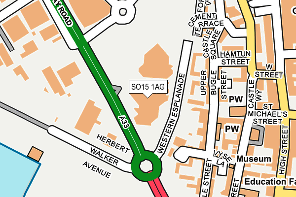
SO15 1AG is located in the Bargate electoral ward, within the unitary authority of Southampton and the English Parliamentary constituency of Southampton, Itchen. The Sub Integrated Care Board (ICB) Location is NHS Hampshire and Isle of Wight ICB - D9Y0V and the police force is Hampshire. This postcode has been in use since December 1994.


GetTheData
Source: OS OpenMap – Local (Ordnance Survey)
Source: OS VectorMap District (Ordnance Survey)
Licence: Open Government Licence (requires attribution)
| Easting | 441746 |
| Northing | 111316 |
| Latitude | 50.899819 |
| Longitude | -1.407733 |
GetTheData
Source: Open Postcode Geo
Licence: Open Government Licence
| Country | England |
| Postcode District | SO15 |
➜ See where SO15 is on a map ➜ Where is Southampton? | |
GetTheData
Source: Land Registry Price Paid Data
Licence: Open Government Licence
Elevation or altitude of SO15 1AG as distance above sea level:
| Metres | Feet | |
|---|---|---|
| Elevation | 10m | 33ft |
Elevation is measured from the approximate centre of the postcode, to the nearest point on an OS contour line from OS Terrain 50, which has contour spacing of ten vertical metres.
➜ How high above sea level am I? Find the elevation of your current position using your device's GPS.
GetTheData
Source: Open Postcode Elevation
Licence: Open Government Licence
| Ward | Bargate |
| Constituency | Southampton, Itchen |
GetTheData
Source: ONS Postcode Database
Licence: Open Government Licence
| Holyrood Church (High Street) | Southampton City Centre | 265m |
| Cruise Crews Only (Castle Way) | Southampton City Centre | 276m |
| Holyrood Church (High Street) | Southampton City Centre | 280m |
| Westquay (Castle Way) | Southampton City Centre | 323m |
| Westquay (Castle Way) | Southampton City Centre | 333m |
| Southampton Town Quay | 0.5km |
| Southampton Central Station | 0.9km |
| Woolston Station | 2.2km |
GetTheData
Source: NaPTAN
Licence: Open Government Licence
GetTheData
Source: ONS Postcode Database
Licence: Open Government Licence


➜ Get more ratings from the Food Standards Agency
GetTheData
Source: Food Standards Agency
Licence: FSA terms & conditions
| Last Collection | |||
|---|---|---|---|
| Location | Mon-Fri | Sat | Distance |
| High Street (163-164) | 18:45 | 12:30 | 308m |
| City Branch Post Office | 18:30 | 12:15 | 323m |
| West Quay Road Ind Estate | 19:00 | 12:00 | 327m |
GetTheData
Source: Dracos
Licence: Creative Commons Attribution-ShareAlike
The below table lists the International Territorial Level (ITL) codes (formerly Nomenclature of Territorial Units for Statistics (NUTS) codes) and Local Administrative Units (LAU) codes for SO15 1AG:
| ITL 1 Code | Name |
|---|---|
| TLJ | South East (England) |
| ITL 2 Code | Name |
| TLJ3 | Hampshire and Isle of Wight |
| ITL 3 Code | Name |
| TLJ32 | Southampton |
| LAU 1 Code | Name |
| E06000045 | Southampton |
GetTheData
Source: ONS Postcode Directory
Licence: Open Government Licence
The below table lists the Census Output Area (OA), Lower Layer Super Output Area (LSOA), and Middle Layer Super Output Area (MSOA) for SO15 1AG:
| Code | Name | |
|---|---|---|
| OA | E00086559 | |
| LSOA | E01017140 | Southampton 023D |
| MSOA | E02003571 | Southampton 023 |
GetTheData
Source: ONS Postcode Directory
Licence: Open Government Licence
| SO14 2AZ | Western Esplanade | 103m |
| SO14 2LF | Bugle Street | 134m |
| SO14 2AG | Bugle Street | 140m |
| SO14 2DX | Bugle Street | 141m |
| SO14 2AY | Westgate Street | 150m |
| SO14 2BJ | Upper Bugle Street | 151m |
| SO14 2AD | St Michaels Square | 163m |
| SO14 2BL | Cement Terrace | 171m |
| SO14 2AS | Merchants Walk | 175m |
| SO14 2AH | Bugle Street | 175m |
GetTheData
Source: Open Postcode Geo; Land Registry Price Paid Data
Licence: Open Government Licence