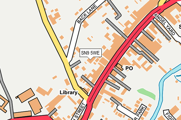
SN9 5WE is located in the Marlborough West electoral ward, within the unitary authority of Wiltshire and the English Parliamentary constituency of Devizes. The Sub Integrated Care Board (ICB) Location is NHS Bath and North East Somerset, Swindon and Wiltshire ICB - 92 and the police force is Wiltshire. This postcode has been in use since January 2005.


GetTheData
Source: OS OpenMap – Local (Ordnance Survey)
Source: OS VectorMap District (Ordnance Survey)
Licence: Open Government Licence (requires attribution)
| Easting | 418620 |
| Northing | 168993 |
| Latitude | 51.419648 |
| Longitude | -1.733617 |
GetTheData
Source: Open Postcode Geo
Licence: Open Government Licence
| Country | England |
| Postcode District | SN9 |
➜ See where SN9 is on a map ➜ Where is Marlborough? | |
GetTheData
Source: Land Registry Price Paid Data
Licence: Open Government Licence
Elevation or altitude of SN9 5WE as distance above sea level:
| Metres | Feet | |
|---|---|---|
| Elevation | 140m | 459ft |
Elevation is measured from the approximate centre of the postcode, to the nearest point on an OS contour line from OS Terrain 50, which has contour spacing of ten vertical metres.
➜ How high above sea level am I? Find the elevation of your current position using your device's GPS.
GetTheData
Source: Open Postcode Elevation
Licence: Open Government Licence
| Ward | Marlborough West |
| Constituency | Devizes |
GetTheData
Source: ONS Postcode Database
Licence: Open Government Licence
| Ladbrokes (High Street) | Marlborough | 88m |
| Lloyds Bank (High Street) | Marlborough | 199m |
| Ducks Meadow (George Lane) | Marlborough | 369m |
| Ducks Meadow (George Lane) | Marlborough | 380m |
| Leisure Centre (College Fields) | Marlborough | 416m |
GetTheData
Source: NaPTAN
Licence: Open Government Licence
GetTheData
Source: ONS Postcode Database
Licence: Open Government Licence


➜ Get more ratings from the Food Standards Agency
GetTheData
Source: Food Standards Agency
Licence: FSA terms & conditions
| Last Collection | |||
|---|---|---|---|
| Location | Mon-Fri | Sat | Distance |
| High Street | 17:00 | 10:45 | 92m |
| River Park | 17:30 | 12:15 | 279m |
| Thr Green | 17:45 | 12:00 | 519m |
GetTheData
Source: Dracos
Licence: Creative Commons Attribution-ShareAlike
The below table lists the International Territorial Level (ITL) codes (formerly Nomenclature of Territorial Units for Statistics (NUTS) codes) and Local Administrative Units (LAU) codes for SN9 5WE:
| ITL 1 Code | Name |
|---|---|
| TLK | South West (England) |
| ITL 2 Code | Name |
| TLK1 | Gloucestershire, Wiltshire and Bath/Bristol area |
| ITL 3 Code | Name |
| TLK15 | Wiltshire |
| LAU 1 Code | Name |
| E06000054 | Wiltshire |
GetTheData
Source: ONS Postcode Directory
Licence: Open Government Licence
The below table lists the Census Output Area (OA), Lower Layer Super Output Area (LSOA), and Middle Layer Super Output Area (MSOA) for SN9 5WE:
| Code | Name | |
|---|---|---|
| OA | E00162515 | |
| LSOA | E01031863 | Wiltshire 019C |
| MSOA | E02006635 | Wiltshire 019 |
GetTheData
Source: ONS Postcode Directory
Licence: Open Government Licence
| SN8 1LT | High Street | 53m |
| SN8 1EL | Chantry Lane | 56m |
| SN8 1JL | Hyde Lane | 74m |
| SN8 1HD | High Street | 74m |
| SN8 1NA | Figgins Lane | 108m |
| SN8 1LW | High Street | 114m |
| SN8 1HL | Wellington Place | 149m |
| SN8 1EN | Cromwell Mews | 149m |
| SN8 1HQ | High Street | 159m |
| SN8 1LZ | High Street | 173m |
GetTheData
Source: Open Postcode Geo; Land Registry Price Paid Data
Licence: Open Government Licence