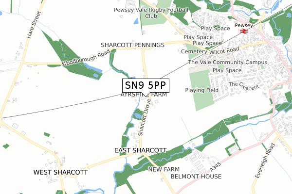
SN9 5PP is located in the Pewsey electoral ward, within the unitary authority of Wiltshire and the English Parliamentary constituency of Devizes. The Sub Integrated Care Board (ICB) Location is NHS Bath and North East Somerset, Swindon and Wiltshire ICB - 92 and the police force is Wiltshire. This postcode has been in use since April 2005.


GetTheData
Source: OS Open Zoomstack (Ordnance Survey)
Licence: Open Government Licence (requires attribution)
Attribution: Contains OS data © Crown copyright and database right 2025
Source: Open Postcode Geo
Licence: Open Government Licence (requires attribution)
Attribution: Contains OS data © Crown copyright and database right 2025; Contains Royal Mail data © Royal Mail copyright and database right 2025; Source: Office for National Statistics licensed under the Open Government Licence v.3.0
| Easting | 415223 |
| Northing | 159808 |
| Latitude | 51.337161 |
| Longitude | -1.782859 |
GetTheData
Source: Open Postcode Geo
Licence: Open Government Licence
| Country | England |
| Postcode District | SN9 |
➜ See where SN9 is on a map | |
GetTheData
Source: Land Registry Price Paid Data
Licence: Open Government Licence
Elevation or altitude of SN9 5PP as distance above sea level:
| Metres | Feet | |
|---|---|---|
| Elevation | 110m | 361ft |
Elevation is measured from the approximate centre of the postcode, to the nearest point on an OS contour line from OS Terrain 50, which has contour spacing of ten vertical metres.
➜ How high above sea level am I? Find the elevation of your current position using your device's GPS.
GetTheData
Source: Open Postcode Elevation
Licence: Open Government Licence
| Ward | Pewsey |
| Constituency | Devizes |
GetTheData
Source: ONS Postcode Database
Licence: Open Government Licence
| Vale Road | Pewsey | 713m |
| Vale School (Wilcot Road) | Pewsey | 730m |
| Vale School (Bus Park) | Pewsey | 732m |
| Rawlins Road (Stratton Road) | Pewsey | 836m |
| Business Park (A345) | Sharcott | 837m |
| Pewsey Station | 1km |
GetTheData
Source: NaPTAN
Licence: Open Government Licence
GetTheData
Source: ONS Postcode Database
Licence: Open Government Licence


➜ Get more ratings from the Food Standards Agency
GetTheData
Source: Food Standards Agency
Licence: FSA terms & conditions
| Last Collection | |||
|---|---|---|---|
| Location | Mon-Fri | Sat | Distance |
| Little Abbotts | 16:15 | 07:00 | 1,141m |
| Swan Corner | 17:30 | 12:00 | 1,177m |
| Canal Bridge | 16:15 | 07:00 | 1,848m |
GetTheData
Source: Dracos
Licence: Creative Commons Attribution-ShareAlike
The below table lists the International Territorial Level (ITL) codes (formerly Nomenclature of Territorial Units for Statistics (NUTS) codes) and Local Administrative Units (LAU) codes for SN9 5PP:
| ITL 1 Code | Name |
|---|---|
| TLK | South West (England) |
| ITL 2 Code | Name |
| TLK1 | Gloucestershire, Wiltshire and Bath/Bristol area |
| ITL 3 Code | Name |
| TLK15 | Wiltshire |
| LAU 1 Code | Name |
| E06000054 | Wiltshire |
GetTheData
Source: ONS Postcode Directory
Licence: Open Government Licence
The below table lists the Census Output Area (OA), Lower Layer Super Output Area (LSOA), and Middle Layer Super Output Area (MSOA) for SN9 5PP:
| Code | Name | |
|---|---|---|
| OA | E00162551 | |
| LSOA | E01031869 | Wiltshire 024B |
| MSOA | E02006636 | Wiltshire 024 |
GetTheData
Source: ONS Postcode Directory
Licence: Open Government Licence
| SN9 5NJ | 440m | |
| SN9 5PA | 450m | |
| SN9 5DT | Broadfields | 585m |
| SN9 5DS | Broadfields | 664m |
| SN9 5JT | Smiths Close | 697m |
| SN9 5NL | Wilcot Road | 717m |
| SN9 5PZ | Salisbury Road Business Park | 721m |
| SN9 5EY | The Links | 740m |
| SN9 5NF | Olympian Road | 761m |
| SN9 5DD | White Horse Drive | 779m |
GetTheData
Source: Open Postcode Geo; Land Registry Price Paid Data
Licence: Open Government Licence